
You are hereForums /

This year's Highland Fling: a true hardman's race? What was your take?

The reports are starting to trickle in, and today's race down in Bundanoon was one for the hardmen - and hard women - by the sound of it.
One of the biggest Marathons of the year, the Fling always draws a great field, who this year were joined on the start line by a world tour road pro - bet you are wondering how he went?  Throw in a whole lot of wet and windy stuff and the recipe looks a treat for those who like to read of adversity, and of overcoming.
If you were down in Bundanoon today we'd love to hear how you went. Why not share in a blog entry linked to our 2013 Highland Fling page. Include your result to get it built into a local leader board and history in your profile.
All the stories are always appreciated by those of us who couldn't make it! 
Trails Database gets some TLC (and more to come)

I'm not sure how much of this people will have noticed, but... thought it was about time to say a few words about our trails DB.
This started out as just a few words about local trails but after a quick glance at the page above you'll see it's grown into much more.
While this section of the site has been here for a long time, it's had a bit of TLC lately (and will get a bit more in the coming weeks & months).
There is a whole load of information here and it can be a bit daunting, so in general the changes are aimed at making it easy to find 'stuff I like'.
The changes so far have been:
- Remove reliance on Google Maps in favour of Leaflet - looks great on mobile.
- Nice little thumbnail maps on the 'At-a-glance' section for each trails area.
- Introduction of a point of information (POI) content type. Instead of just listing facilities we can now pinpoint them on a map (with relevant icons of course).
- Maps for individual areas can now show trails colour coded by difficulty (where authors have rated them), as well as those POIs.
- As well as the Northern Beaches area overview map on the trails DB overview there's a new Trails Finder page that shows all the areas to ride on a map.
- A little reminder message on all these content types: this is a site for the MTB community, and as trail info can often change, anyone is welcome to contribute with better information if they have it. You know - just like a wiki.
Well, that's for a start... there's more coming! Yes, a nerd's work is never done!
Total fire ban & closures for Sydney National Parks (13 Oct)
Today (13 October) NPWS are reporting that due to a total fire ban, many National Parks in Sydney and surrounds are closed.
Eg. for Ku-ring-gai Chase:
Total Fire Ban
All tracks and trails across all of the Metropolitan National Parks are closed Sunday 13 October 2013 due to Total Fire Ban. West Head Road is closed, however the basin campground will remain open.
Many other parks around Sydney have similar warnings. Many thanks to the guys who put in all the trail status updates to alert us to this - nothing worse than turning up to a trail and finding out it's closed 
More details on NPWS page:
Extreme fire danger & closures for Sydney National Parks
Today (October 10) RFS and NPWS are reporting an extreme risk of fires in many National Parks in Sydney and surrounds.
Eg. for Garigal National Park (Oxford Falls, Cascades, Bantry Bay):
ALL WALKING TRACKS AND TRAILS CLOSED THURSDAY 10TH OCTOBER
Due to the high fire danger predictions, all walking tracks and trails will be CLOSED ON THURSDAY 10th OCTOBER. Picnic areas will be open and the public may only use the gas/electric barbeques supplied by the National Park.
Locations affected: Cascades trail, Heath and Bare Creek trails, Pipeline and Davidson Trails, Natural Bridge track to Davidson Park, Davidson Park to Stepping Stone Crossing walk, Stepping Stone Crossing to Cascades
Many other parks around Sydney have similar warnings. West Head road in Ku-ring-gai Chase is closed for example which will mean access to many tracks in that park is impossible.
More details on NPWS and RFS pages:
http://www.environment.nsw.gov.au/NationalParks/...
http://www.rfs.nsw.gov.au/
Saturday,October 5 is IMBA take a Kid (or Mom) Mountain Biking day

Heads up for everyone out there who might usually be having a hard time getting their family out riding with them: This Saturday (October 5) is IMBA's Take a Kid Mountain Biking Day. As this is the 10th anniversary, they have, rather tongue in cheek I think, crossed out the 'kid' and replaced with 'mom' as a way of saying it really is for all the family.
TKMBD is an annual celebration held on the first Saturday of October. The event, developed and coordinated by IMBA, strives to encourage communities around the world to join together and ride mountain bikes with youth.
To be honest, that's about all you need to know: it's an excuse to drag your family or friends out on the dirt and get them grinning 
For those wanting to know more about the background, details on the IMBA site here: http://www.imba.com/tkmbd
If anyone wants to arrange something 'official' for this day somewhere around the Northern Beaches, please put it in the calendar and comment here so we can give it a plug.
Riding (or spectating) options for the coming weekend

Time to take a quick look at your various mountain bike options this weekend - Sep 28/29 if you're reading this late
Early Saturday morning, for those that fancy a trip an hour or so up the road there's Geoff's Ourimbah Burn ride. I'm guessing this is just a warm up for him, because as he explained in another post...
I'm participating in the Great Cycle Challenge throughout October, I have pledged to ride 1000km for the month in support of the fight against children's cancer.
Good on ya Geoff! To show support, why not go have a couple of laps on Saturday, or online, see:
https://greatcyclechallenge.com.au/Riders/GeoffG...
Closer to home, on Sunday there's Hawkeye's Duck Holes, Centre, Perimeter, St Ives Sniggle & return. Sounds like a nice little loop... I might even show up
Finally, if you're wondering about the image, don't forget that on Sunday the 2013 NSWMTB State DH Championships are being run up on Hassans Walls. Our good mate Flynny from CTMBC is running around like a headless chook with all the last minute preparations but asked us to pass on this invite...
Feel free to come on up and see why the states best downhill mountain bikers love coming to Lithgow. Great action packed weekend with plenty of spills and thrills for spectators all for the cost of a donation for parking.
Parking is within the Lithgow Pony Club grounds in Sheedies Gully, just off Hassans Walls rd.
So there you go. Riding or watching, get out there and enjoy
Knapsack DH officially opens this Saturday!

Please excuse the cross-post, but our friends over in BMORC have some great news worth spreading - The Knapsack Reserve DH track will officially open this weekend.
This Saturday the 21st at 9:30am Blue Mountains Council will be doing the official opening ceremony of the Knapsack DH track. This should include some councillors and BMCC officials and staff that have been involved or interested in the project.
Meet either at the gate on Barnett St of Lovers Walk or at the Trail head sign at the track head at 9:45am.
As if riders keen for some gravity fuelled action needed more encouragement, their post (see Official Opening of Knapsack DH This Saturday 21st September) mentions they are trying to get a BBQ going too.
Get on up there and enjoy!
Reminder: Terrey Hills Perimeter Trail closed until October 18

Given the popularity of the Perimeter Trail at Terrey Hills, it's probably worth highlighting yesterday's trail status update (and discussion: Long and Perim trails closing for 6 weeks from Sept 4).
That is, NPWS are conducting maintenance on the Perimeter Trail which will be closed between intersections with the Long Trail and Smiths Creek Trail until October 18. This effectively makes trying to use the Perimeter Trail pointless.
That is, except for riders who are still keen to ride the Long Track, who can start at the West end of Perimeter (eg. take Mallawa Rd then Bulara St to the trail head).
If you rarely venture that way, it is a nice change and an opportunity to head along Cullamine Track and do the Duffys Track (Slades Lookout) out and back perhaps. Throw Cowan out and back in as well, or explore some of the lesser known fire trails South of Booralie Road (Sandy, etc) and you've got yourself a pretty decent ride.
P.S. Thanks to Brian for great photo: midweek sunrise at the end of the Long Track. Gee, some people are keen!
Give back to the trails by coming on a dig day! Plus weed spread prevention.

There's a fair chance that many reading this will have had a blast on their local trails this weekend. That's all good, but did you ever wonder who put those trails there in the first place? Yes, yes... I'm sure many of you already know the answer: the mythical Trail Fairies
Good as those fairies are though, sometimes they need a hand in their work. So we're just putting a gentle request out there: please consider coming along to help out on one of the upcoming maintenance days.
RSVP to a dig day organised by your local land manager, show up and lend a hand. Hard work, but more fun than you'd think. And there's nothing more satisfying than riding on a track that you helped maintain or improve.
A reminder of trail days coming up in the next few weeks:
OMV Maintenance Session - Sat 7 Sep @ 2pm
Yellomundee RP - track maintenance - Sat 14 Sep @ 8:30am
Manly Dam - trail maintenance afternoon - Sat 21 Sep @ 1pm
Preventing Weed Spread
While we're on the topic of trail care, there's been some new talk in the forum about weed spread. See Phytophthora cinnamomi.(dieback). This might be a good time to mention that weeds and other nasties can be spread between trails when picked up on your bike. Land managers like National Parks & Mt Annan Botanical Garden are always keen to communicate the message of prevention:
- Try to avoid riding in wet conditions, which cause more mud/debris to cling to your bike.
- Always wash your bike/shoes/etc. after riding.
- Preferably wash your bike at the trail head - keep the soil you picked up in the area.
- Preferably disinfect your bike by spraying with 70% methylated spirits diluted with water.
- If you prefer to wash your bike at home, do so on a hard surface away from grass, etc.
Join a ride: Sat @ Manly Dam, Sun @ Terrey Hills

If you're in Sydney and looking out of the window right now things might look very promising for the weekend, but... the forecast is good so it's time to think about where to ride.
Last week we asked, Where are you riding this weekend?
This week we give thanks to those who share their plans in advance in the calendar, inviting others along for the ride. That's exactly what this site is about. Getting out there, having fun, meeting new people.
Is there any better way to explain that then to take a look at the smiling 'old time' faces from a group ride at Manly Dam last weekend. Looked like a perfect day all round!
So why not join a ride at Manly Dam Saturday Morning or Terrey hills / St Ives on Sunday? Announce your intent by clicking the "...change to show you're in" link on the meeting page. If these don't suit, everyone is welcome to post up their plans if they'd like some company.
And again, thanks to the ride posters, and please keep it up. Remember - if you don't get any takers just keep trying - there's plenty of guys out there reading this who may join you next time.

Volunteers needed for Bikes 4 Life workshop, 28th July, 171 Gibbs Street. Chatswood

Join our bike fixing workshop for "Bikes 4 Life" - on 28th July, at 171 Gibbs Street, Chatswood (northern End, behind Bunnings).
No special skills or tools required - if you can pump up a tyre, you can help. Come for an hour, or come for the day. Tools, Lunch and Music is provided. This event is organised by Chris, one of our local Northern Beaches MTB'ing mates. So far he and his volunteers have collected, fixed up and sent over 400 bikes to needy people in remote communities in Africa and Australia.

For those that commute
Slightly off-topic however a lot of folks here commute as well as MTB - Rideable.org have done a survery of winter commuter riding in Sydney, have a look at the video on Rideable
Garigal NP/Bantry Bay Proposed Trails - Act Now!

There have been a couple of threads go up on the form about this, but this is actually big, BIG news so please take note.
NPWS have out for comment some proposed amendments to Garigal National Park plan of management. These include construction of a Mountain Bike Track Bantry Bay. Ie. a step closer to the long awaited authorised access to this area.
It's in everyone's interest to get behind this... which is as easy as visiting this page...
... and completing the form with some words like, "I'm a keen parks user who fully supports the proposal to create sustainable mountain bike trails at Bantry Bay, and anywhere else in the Sydney's suburban parks for that matter.". Of course, don't use those exact words, but you get the gist.
More details and discussion in these threads (comments on this news item are intentionally disabled):
NPWS Bantry Bay Proposed Trails - Open for Comment - NEW NORTHERN BEACHES MTB TRAILS
NPWS Release of docos for public exhibition (AND COMMENT)
NSW NPWS Surveys

I know this has been discussed already, but a timely reminder that there are just a few days left to complete the Berowra Valley National Park & Regional Park Survey at this address:
http://www.surveymonkey.com/s/berowravalley2013
The old Plan of Management is currently being updated. We would like to gauge the public’s interest and general themes for the park to guide the draft plan. We encourage you to provide your feedback via the following survey monkey. Feedback closes 12 May 2013.
Now also might be a good time to mention the Landscape Values Institute is still live and can be found here:
http://www.landscapemap2.org/nswmtnbike/
Happy surveying!

OMV (a.k.a. Hornsby MTB Park) is now officially open to the general public
OMV (a.k.a. Hornsby MTB Park) is now officially open to the general public.
Old Man's Valley Official Opening Postponed
This normally wouldn't make front page news, but given the last story...
Sorry folks, due to bad weather the OMV official opening has been postponed. The track will remain closed for the foreseeable future.
We've waited this long... please respect this decision and be patient.
Old Man's Valley Official Opening & Post Ceremony Ride
There's a very exciting weekend coming... and also some confusion over what is happening so please take note:
On Saturday Feb 2 Old Man's Valley will officially be opened by Hornsby Council. As some may have heard, there will be an official ceremony in the morning.
This ceremony is invitation only. No matter how much you appreciate their efforts, please give the council the space they need to perform these official duties.
Following the ceremony, the track will be open to all from midday on. See our ride: OMV Midday Ride (Post Official Opening).
Now... let's hope for some nice weather!
New Server Sponsor
Just a quick note to let everyone know that we've just moved server to a new site sponsor.
Please give a give round of applause to the very nice people at Demon-Host
As part of the migration I took the opportunity to update a few bits of the site software too. Everything looks to be running smoothly, but it may be that the software rodents have missed something. Please mention it ASAP if you see any problems or unusual behaviour.
Please don't forget to complete the NSW National Parks survey
If you've got a few minutes over the holiday break then please don't forget to head on over to the Mountain Bike Riding in NSW National Parks survey and add your input. Link here:
http://www.landscapemap2.org/nswmtnbike/
More on this and discussion at the original NSW National Parks Mountain Biking Survey thread (thanks wilso_ac).
Notification of proposed Hazard Reduction Burn in Royal National Park-Loftus Trails 8/9 September

Just an update on the proposed burn in Royal National Park. It did not proceed last weekend due to high winds but is currently being proposed for this weekend the 8th and 9th September.
NPWS are planning a large Hazard Reduction burn for the Temptation Creek area of the Royal National Park (including the single-track areas accessed from Loftus Oval). At the moment the planned date is Saturday 1st September to Monday 3rd September. It’s likely the trails will be closed for a while after that as well until they can be assessed as safe for the public to enter.

Red hill trails
Simon has posted a message about trail damage at red hill that potentially affects everyone... See more here..
Draft Pittwater Open Space and Recreation Strategy
Just received the following message from Pittwater council:
Pittwater Council is preparing an Open Space and Recreation Strategy which may of interest to your club or association and members.
The strategy will help Council manage its reserves and parks in terms of conservation, leisure and sporting activities. An important part of the project is to understand how Pittwater residents use open space, what they value about it and what can be done to improve it. Council is inviting residents to complete a survey to help them with this process.
Pittwater is unique due to its range of landscape settings - from beaches, waterways, wetlands, escarpments to developed sports grounds and villages. As Pittwater's custodians, a key component of the project will be the protection and enhancement of the natural environment. We will also be looking at how to provide a diverse range of recreational opportunities for people of all ages and abilities appropriate to the natural environment.
With this in mind, the survey focuses on landscape settings. Please take time to consider the landscape settings and their importance, taking into account of your needs, as well as the needs of the community as a whole.
The survey can be accessed at: www.pittwater.nsw.gov.au/consultation
The closing date for the survey is 22 June 2012.
Once the surveys have been received and collated, Council will organise a community workshop to discuss the results and their influence on the planning process.
Residents completing the survey can enter a draw to win a dinner voucher for $150 at a restaurant of their choice.
NoBMoB appears in Manly Daily
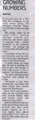
A couple of weeks ago, Bryn from the Manly Daily called to find out some more about NoBMoB. Here is an image from the paper of the story.
Report backs new tracks for mountain bike riders

From the Manly Daily:
SEVERAL opportunities for new mountain bike trails and dirt jumps have been identified in a recent report commissioned by Warringah Council.
Mayor Michael Regan said the council had already give “in-principle” agreement to link trails at Forestville Park to new tracks being built at Garigal National Park.
The paper it discusses can be downloaded here:
Mountain Biking in Warringah Research and Directions.
This is currently on the council's public comment page which says:
Submissions are to be addressed to the General Manager and can be emailed to [email protected] or posted to the Civic Centre, 725 Pittwater Road Dee Why 2099.
Give us your comments by COB Thursday 15 December.
Full story in the Daily:
Manly Dam is CLOSED weekend 26/27 Nov
Sorry to say, but as can only be expected after all this rain Manly Dam will be closed this weekend (26/27 Nov). See Manly Dam update for 25 Nov.
Interestingly this week there has been a rather heated discussion about the merits of the trail status system (aka. traffic lights - see Latest Trail Status feature) so at this point it's probably worth mentioning that this is a community site and relies on the interaction of that community for features like the traffic lights to stay current.
So a big shout out to all those who get involved and let everyone know about the status of local trails. Thank you