You are hereForums / Archives / Tentative Planning (MTB) / Watagan Forest Rd
Watagan Forest Rd

always with the looking around for something to do
a little bit different
or just seeing great places
Ourimbah gives me the idea of slogging up the incline to ride a lot along the top.
and the next ridge up shows a nice ridge line, that goes on and on .....
so to start at the other end needs to be a 400meter climb in 2kms to get to the start
that's a hard 1 in 5, probably greater if it starts of easy early
Map My Ride route
(the hard part of Red Hill Rd at Ourimbah State is just under 1 in 5)
followed by 52kms of long downhill
the regular blue mountains riders would probably just do the 52km grind up and then come back 
- Login to post comments
- Bookmark & share
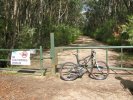
We did a reasonable loop up there about a year ago. Watagan Forest Road is a bit dusty and can be heavily used by 4WD tourists so is not ideal, but is OK in the morning before they get going. We turned off at Whiteman Ridge Trail which quite pleasant, with a nice narrow ridge in the middle, where the trail actually stops with a 10metre hike-a-bike section down a drop (may be ridable by braver souls than us). This isn't what's on the map so be careful especially if you do it the other way round. The Maculata trail follows with an interesting descent to the valley floor . We completed the loop with the Brothers trail back to the car. All up 30 klm mainly fire trail but some tech stuff on the descent and some nice views .