You are hereBirds Eye & Maps / Whistler/Rotorua/WSN Belrose Comparison
Whistler/Rotorua/WSN Belrose Comparison

Over the years there's been bit of enthusiasm about the potential for MTB activities at the WSN Site at Belrose (aka. Belrose Tip). Obviously, any development that works for mountain bike riders is a good thing, and broadly supported by the MTB community.
Unfortunately, when I looked into this one in a bit more detail, I started to get a little worried that we might be focusing too much effort on a project that just can't work out was we might have hoped.
Indeed, any notion I had that this might be the Northern Beaches answer to Whistler or Rotorua or something was quickly dispelled, when I put some work into finding out just what the site could offer.
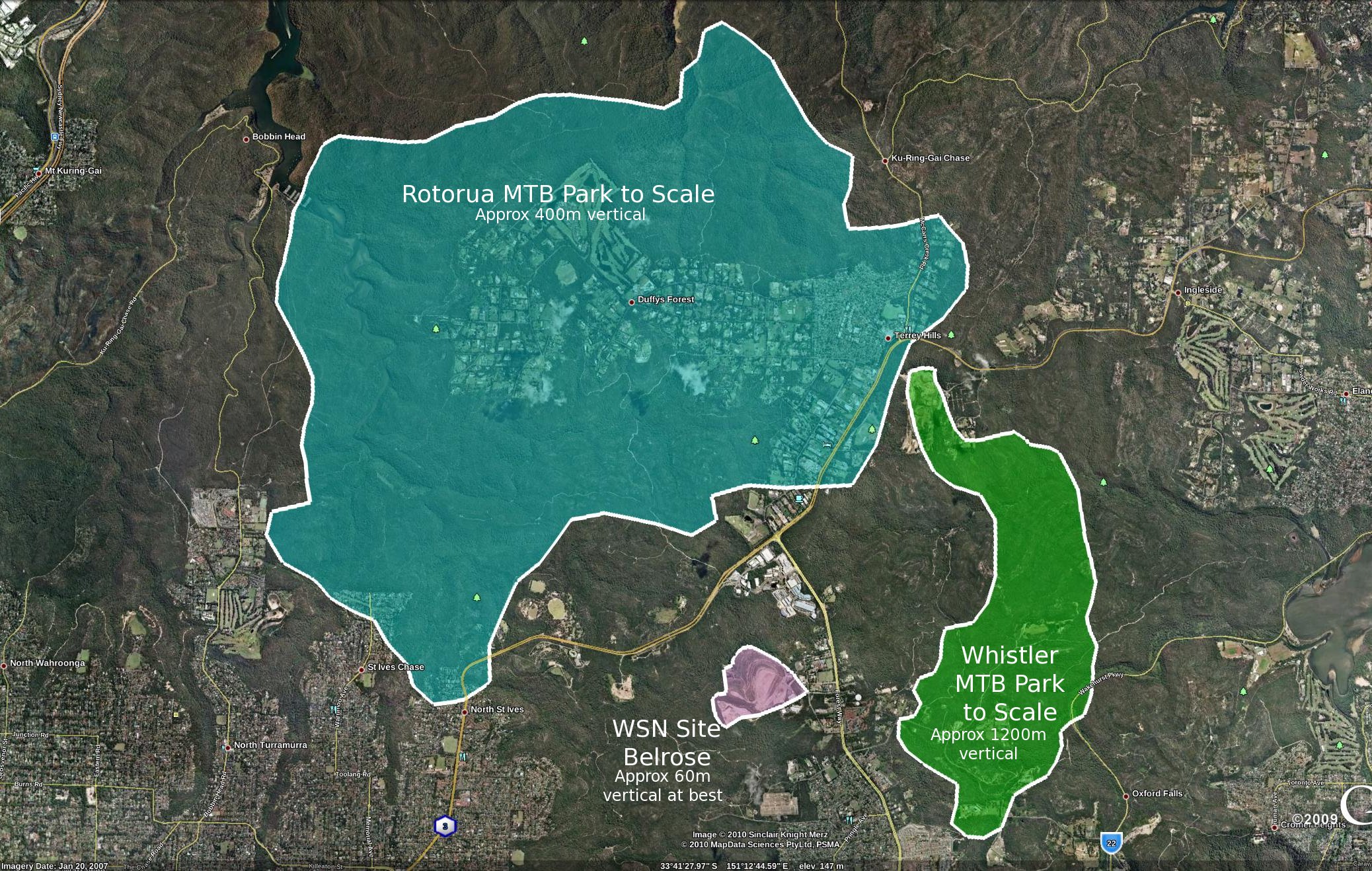
Hopefully, one day, the WSN site might make up a small part of the riding mix in the Northern Beaches (if and when it's eventually closed (after being delayed many years already that's not going to be any time soon) and if it's found suitably safe after closure and can be rehabilitated properly). But, as you can see by the areas alone, there's no way this is ever going to be much more than a small area, possibly suitable for 4X, or DJ or trails, or something like that. Hopefully, once there are some more developed XC trails, you could possibly throw in some links in the area to those trails (for example, Cascades in Garigal National Park to the West). But I assume we would certainly prefer to get those trails established more effectively first...
On the vertical front, I'd estimate you'd be lucky to get 60m right now, who knows what when it's filled. To compare, Rotorua has around 400m, Whistler around 1200m!
So - figured it was worth putting up a short note to make sure we keep this one in context. A more useful focus for the community in the near term perhaps needs to be on more broadly useful opportunities, which can provide a better footprint for a broader variety of users!


- Login to post comments
- Bookmark & share
Redwood's carpark!

Oh well, at least it's something... (trying desperately to cling onto any bit of hope for NB MTB)
Jeez - I thought the tip had much more potential than that. It's really highlighted how little we have to play with.
I wonder what the Stomlo overview would look like.....Rob?
So true Rob, The tip is by far the answer to the problem, rather part of it. It is far to small and not high enough for all disciplines and would be an unpleasant place to ride due to their being no natural terrain and it being an ex tip.
So it would only be suitable for man made riding such as BMX, DJ, FR, 4X, trials and skills building area's
For sustainable XC there is much potential for trails in Garigal NP and a proper single trail loops and or connections between Red hill and sport and rec reserve.
For sustainable DH a study must be done of the most suitable land with the highest elevation and the longest elevation drop. And fire trail or bitumen road access at the bottom for shuttles. Terry hills and surrounding area has 200-215m elevation, and would be a natural starting place for a study of where a sustainable trail could be built.There is plenty of less environmentally sensitive land that would be suitable for sustainable DH both within and outside Garigal.
Red Hill has some good elevation at 160m and has a bitumen shuttle road/car park already built, DJ's nearby. Official DH trail exit pickup point would need to be built.
Cromer end DH would need official shuttle/maintenance road graded in, from back of sport and rec grounds and although being 100-120m elevation has some great potential for sustainable DH.
Like Rob Says, The key is to cater for all needs, just as they do overseas and elsewhere in oz.
Great work with the comparo Rob, really puts things in perspective!