You are hereForums / By Discipline / Mountain (off road) / By Location / Australia / NSW / Blue Mountains / Blue Mountains Trail Advocacy / Linden Ridge Single track
Linden Ridge Single track

G'day guys,
I have been liaising with NPWS to try and get approval to trim back the Linden Ridge single track.
It's been a slow process and we still don't have approval. Firstly they had to work out who's jurisdiction it belonged to. That has been solved now they need to know more about the track as there isn't much known about.
The ranger in charge has been out to investigate but could not find its start or the photographed sign post found in our rides database.
Can anyone verify if the signpost is still there with a recent photo and record it's coordinates with a smart phone or similar?
Cheers,
Tim
- Login to post comments
- Bookmark & share
I think the sign may be gone or covered up. I went out the firetrail less than 2 months ago, not intending to ride the single track because of it's state but don't recall seeing the sign.
I will see if I can get out and take a look, I have a mate that rides it regularly I will ask him.
Cheers Stephen,
if you or anyone else can also get photos of the track start plus any significant landmarks like a large rock or trees that can help Identetify the location on ground would be very beneficial.
Thinking of a recce ride up here to help gps the trails.
Mebbe this Sat.
But don't know of any existing signs or trails, at all.
It has been mapped bmorc.com/node/18107/map
And I gave this map to the ranger but it wasn't good enough for him to find the trail.
I understand that at the moment it's unrideable due to the overgrowth.
Found an old log of Linden Ridge - the single track starts at exactly 3.50km at the big right turn - you can see it on the Satellite view
http://www.brytonsport.com/mapTrackView/2?id=326244
There's a map here that shows where it is too
http://www.trailflix.com.au/tfx_new/trails.php?i...
I have definitely seen the little sign there and am pretty sure it is still there - will ride out with Stephen in the morning and take a look
Is it possible to link Lake Woodford and Linden Ridge, like i've traced on the bellow map (cyan line)?

Yep - you have to carry your bike a little - here is a recorded ride doing so:
http://www.brytonsport.com/mapTrackView/2?id=458745
I would have said no, as far as I knew the only crossing was the Dam itself. Is there another crossing?
Yep - down to the left from where you are standing where you took that photo.
If you zoom in on google satellite view you will see a bridge coming from a shed. As far as I can see this is not a special area as it is 20m or so from the Dam wall
I should note that I came down from the top and there are definitely no signs - I will ride around there on the weekend and make sure from both sides - just to make sure we are allowed to ride through there
I was thinking about heading ou
t for a ride Saturday morning
Went out this morning with James. Funny, it looks like the NP guy has actually done a u turn in front of the Single Track start.
The ride cost me a derailure and spoke
Someone has actually done some pruning back along the trail, the green waste does not look all that old maybe a month or 2. We didn't go more than a few hundred meters down so not sure how much pruning was done, it still needs plenty of attention though.
As posted above the ST starts exactly 3.5kms from the Glossop Road gate.
Looking down the main fire trail the ST starts at the bikes.
GPS coordinates taken at the Fire Trail - Single Track junction
That's how I remember the start of the single track.
Looks like I was wrong - I rode down today. From the west side there are in fact signs. So please disregard my comments above - you are not allowed to connect Linden ridge with Lake Woodford.
When I rode in from the East there were no signs. I don't know if those pictured below were there at the time - or if I did not see them simply because I was riding past from behind?
Either way I will not be repeating the ride I linked above - which is probably a good thing since I stacked it bad riding down that hill
Hmm not sure how to link a photo - but trust me the signs are there
I did a recon ride myself on saturday. Started from the end of Woodford Ave. The fire-trail from here was really nice to ride on, it has been graded within the last few months. I wanted to see If I could connect up to Linden ridge from here. Unfortunately after almost reaching the bottom of the decent with most being hike-a-bike the land was to wet with running water seeping out of the soil. The track did continue further but it was highly over grown and not rideable. I did not see any potential in this track and decided to retreat with a hike-a-bike back to the top. I continued out to the Dam and was really impressed with the difference in the trail in comparison from when I last rode it.
Got to the damn, and took the little bridge to cross over. jmckid, you have failed to mention the hike-a-bike up on the other side, scratch that, it was a climb-a-bike. Took me over half an hour just to get to the fire trail climbing up that hill with my Mtn bike in bike shoes. Was bloody ridiculous. sign or no sign, I don't think its worth advertising. LoL
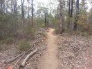
I rode out and found the linden ridge single track. Managed to ride 2.2km before I needed to turn around from the overgrowth. This track is really something special and loved every moment of it. Made it so disappointing to have to turn around so early. I noticed that this trail was originally bench cut at car width.
I have sent an email off to the ranger, I'm really hoping we can make something special of this.
Haha you are right - I went down that way - up would be pretty hard carrying the bike!
Definitely not a ridable rout to advertise
I rode up from the dam wall to Winbourne this afternoon - that is a hard climb!
I have tried to get through to Linden ridge the way you tried too - I think you would have to go through someone's backyard - at least you can ride that hill now since they rolled it - but its all a pretty boring freeway now - used to be more fun
Email response
I really hope we Haven't shot ourselves in the foot trying to do the right thing.
I couldn't imagine it would require a large resource. It's just a few people wanting to take some loppers to prune the bush every so often.
If the Blue Gum Swamp area receives no maintenance by NPWS, Linden Ridge will probably get Sweet FA!
Yeah agree with JP, Blue Gum is a bit of a barometer!
Sorry Guys, Bad news
What the?
Tim I used to ride the ridge many times some years ago, haven't done it for a while and by the response doesn't look like I will again. It used to be a great trail ride along some great cliff lines. It did just end though in the scrub, no look out views or anything spectacular but a great ride non the less.
That sucks.
I posted an update on the Linden Ridge thread, this post is mean mainly as a cross-reference.
The ranger is correct to remove NPWS' sign, since they normally don't allow signs in wilderness.
They put it up themselves of course, long after the wilderness declaration.
That said, numerous managed and maintained fire trails exist in wilderness, Faulco Point and Lawson Ridge being just two of them. The main discriminator for parks is whether they maintain the trail or not, and they wouldn't maintain a fire trail that isn't used (eg. for firefighting). And of course they articulate their access policies in their plans of management.
As it happens I don't think he/she did remove the offending sign. Which is a shame really, it is fairly pointless. Still, by writing that he/she would remove the sign on the next patrol the ranger may very well have been perfectly truthful... patrols of tracks which cannot be driven in a 4WD are not terribly frequent.
All is not lost however. The track is still there as are many many others in the same category. For instance the wild ones in Kanangra-Boyd that the Kanangra Classic organizers cannot use for racing. In the same breath however the ranger's use of the phrase "will be closed" is perhaps odd grammar as they didn't actually close it and it is very much open for self-reliant recreation.
The bottom line is parks' intention is that it become overgrown through eventual disuse, closure in that sense in other words. This certainly happens when tracks are entirely disused.
In this case the Dawes Ridge singletrack isn't entirely disused, on account of self-reliant recreational use. And long may that continue!