You are here
map


Sydney trails overlayed on google maps.
https://mapsengine.google.com/map/embed?mid=zBN7...
I made this for personal use because I was tired of checking for trails to only find out they are well over an hour away. After making it I figured someone else might find it useful. This has the name, nobmob link, and meeting point from the trails in the northern beaches, blue mountains, and sydney north, south, and west. Some trails are not listed because they lack a meeting point or something else.
Disclaimer: I am not responsible if any the information on this map is not correct.

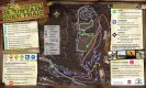

Kiwarrak Single Track Map

Glenrock loop suggestions?
I'm hoping to take my wife up to Glenrock for a cruisy explore on Sunday morning and was just wondering if anyone with experience has a loop that they would like to recommend to me? Are there any arrows or signposts there?
I've downloaded all of the NobMob maps to my Edge 705 and would like to piece a bit of a ride together before we head off.... I think I would be more popular if I know where I'm going.

MotionX-GPS on my iPhone
I just downloaded a free app on my iPhone from the app store called MotionX-GPS. I got the light version which is free and there is another version which you pay about $3 for. The free one is unreal, but i may end up getting the paid version to support this great developer.
Anyhow below is the information that it gave me after a ride when i chose the option to email the ride (track) to me. To test it i just did a road ride around Homebush and didn't start it properly until i got to Silverwater.
Get Lost, got lost
I'm planning a weekend trip to Ouriumbha with me bird and I'm wondering if anyone has any tips on not getting lost.
Since i've been here i've been to cascade, manly dam, oxford falls, narrabean lake (although ended up in oxford falls) and the place down south campbell town with the xc course, and every time i've been completely lost.
Now it doesn't help that i get lost walking to the shops or driving to work, but i was wondering if anyone can recommend any maps (and where to buy them), techniques, sat nav (i have a garmin for my car) or otherwise (bread crumbs etc) to assist.