You are here
White
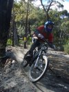
Thredbo Pipeline Path
PIPELINE PATH
Level: Beginner
Distance: 2 km
Style: Flow
With only a slight undulation you loop around the southern end of the village along the Thredbo River. Keep pedalling onto the Friday Flat Loop, Bridle Loop or Thredbo Valley Track or simply follow the track behind the big carpark, onto Friday Drive back to the village.
Old Great Western Highway Shared Path
Once a rail road and later a highway, it is now just a shared path for Pedestrians and Cyclists.
Bathurst pump track
As of November 2013 this looks to be a work in progress and a little over grown.
TBH I could barely get it with out a pedal stroke or two but then I'm not the best at pump track either.
A fun little loop that will get better with some wheels over it and further work to extend it.
Summit Loop
Loop around the summit joining the 2 main fire trails up from Jesmond Park and the John Hunter Hospital exits. Single tracks also split the summit and drop off down the hill from the side.
Sygna Close Easy Access trail
Very easy access trail that is actually sealed in a loose bitumen. Trail ends with an option of climbing out to McCaffry Drive or up to John Hunter Hospital carparks.
Newnes Rail Trail
This is the bottom section of the old rail line that linked the Newnes shale mines in the Wolgan Valley to Newnes Junction (Zig Zag Rail way car park at Clarence)
Friends of the Newnes railway are pushing for the entire length of the rail corridor to be made into a "rail trail" which will give a fantastic ride.
At the moment the top sections are over grown and unridable in places and the section from the Tunnel Car park to the Tunnels is off limit to riders (dismount and walk, or take the detour down the coach road )
Enduro Loop (Rail easement)
This one follows a section of the old Newnes railway before hooking up with old forestry roads leading back to the Black Fellows Hand rd.
This is an easy way back to the picnic area from the end of the Whoops track but also gives access to as couple of other Single trail loops
Berghoffers pass
Way back int he days of early automobiles people found that Mt Victoria pass was to steep for these new fangled horseless carts. As the team of oxen employed to drag cars up was expensive and slow a new road was cut tot he side on a much gentler gradiant. Berghoffers pass
I don't think it was use for long but it has lasted and now makes for an easier ride up through the escarpment and a fun descent. It's a great way to start and finish a loop of the Mt York Convict trails.