You are here
Site topics

What app did you use to create and tag your maps
Hi Guys
Just wondering what app you used to create and tag your maps.
Cheers
Aaron

kiwarrak
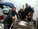
Just spent a couple of days rideing kiwarrak & had a ball ,nice & smooth with not many climbs ,the downhill run with jumps a dropoff & the big berm were probly the highlight ,the bridges & seasaw over the creek were cool too .I was wondering how the trails handle with the multy direction single trail & if there have been many collisions ,also what has happened to the trail signage ? arrows & crosses constantly contradict each other & quiet a few arrows seem t b missing which made it real easy t get lost .Dispite this we had a great time & would like to thank the trail builders for their work.

Thanks Rob
with all the recent rain I've had the need to use the Weather and Trail Status features more than I would like to. So just wanted to say thanks to you and those that update them as they are very useful resources to use when deciding whether or not to hit the trails. We headed to Wingello on Sunday with a rather large group, I used the Weather section for historical rainfall and the weatherchannel for current situation. It rained for the first 5-10min of the ride but then the sun came out and we had an awesome ride. Trails were in perfect condition.
Keep up the good work.

Latest Trail Status feature
So I see Manly Dam, Lane Cove and Yellomundee are currently a green light. I guess they are "latest" status, but really.. does it serve any point? Those 3 rides would be washed out with rain and currently not ridable.
MANLY
Actually I have not had a manly ranger email, so I'm guessing Manly must be open, even though we have had so much rain. Seems crazy.
YELLOMUNDEE
I doubt WSMTB would like anybody heading to Yellomundee Regional Park to ride.
LCNP

altitude
just noticed a few trails with nice tracking and length but no altitude
thinking I need things to do, is there places you'd like to see the up/down so I can get off my fat/lazy butt and get out, maybe only walking, but still, I got a GPS or 4 that can track these things.
you want updates ? ask ...
[Mod. moved to site topics]

Imagecache Migration
In case anyone noticed (and not sure they should have)...
I've just modified the way images are handled on the site. Please shout out if you see anything 'funny' happening with them (missing images, images with strange aspect ratios or sizes, etc).
For those that want to know what I'm talking about...
Some image gallery changes
Just a heads up...
I've been making some changes to the way image galleries work tonight so please shout out if you see any 'funny' things happening.
The way ride meeting galleries have been working in the past was less than ideal. One had to create a gallery then post images into that gallery, but because there were an ever growing number it was a real PITA to find the right one.
NoBMoB Weather is back
Ahem... 
Some keyed eyed views had noticed the NoBMoB Weather wasn't quite matching with what's happening outside lately.
This was as the BOM turned off the old Sydney feed and only now have information from the Terrey Hills station in this area and the data grabber/loader needed updating.
All done now, so there you go:
Although please note it will take some time before the new feed 'fills' the 10 day graph and even longer for the others of course.
P.S. Also added Awaba into the list of places monitored 
Random Track Additions
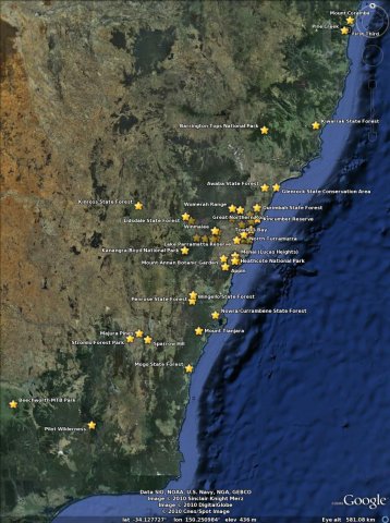
In case anyone noticed I've been adding some tracks to various places today. This may seem apparently random, but there is a reason:
See, I've also updated the Master KML File (aka. Google Earth feed) to only load/show detail when one zooms into an area. This makes things look a lot neater at a high level (see attached) and may have a side effect of making viewing this file in Google Earth faster... although I can't really tell 
iCal Fixed
I'm not sure anyone is even using this as there have been no complaints, but...
... the previously borken[1] iCal feed should now be working:
http://nobmob.com/calendar/ical
Or substitute 'nobmob.com' for your favourite Global Riders site[2]
This should show the last week, plus 90 days into the future. As I imported this a Google calendar to test though, and as Google shares imports, on Google it's only showing this month at the moment. Should change on their next refresh.
[1] This is a deliberate typo