You are hereMaps
Maps
Click on the images for larger view (then, as with most of our pics, you can click the 'view original' link under the picture to get even larger).
NB: If you don't have the luxury of running the Google Earth application it's also possible to look at maps using the web based Google Maps... more on that below.
Using Google Earth
1. First Open
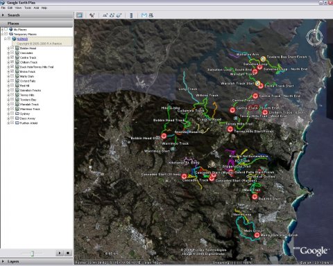
OK then - when you first click the NoBMoB KML link it should open up in Google Earth. Barring any layer and 'My Places' stuff (which I've hidden away for the walk through) things should look pretty much like this:
2. Expand Manly Dam
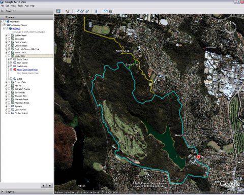
We'll use the old favourite Manly Dam as an example of capabilities, double click on it there on the left 'Places' sidebar. You'll be zoomed in, plus, some detail in this folder will be seen:
3. Turn on Detail
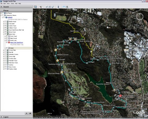
Pretty basic, eh? So all these pictures we've got lying around... "Where are they taken?" you're asking. Just click the check box next to 'detail' and voila!
4. Highlight Detail
Want to see the pictures in here? Just click the hyperlink (not the little icon, the underlined blue text) in any of the detail items:
If you then click on the thumbnail within the dialog that pops up, hey, you're taken right here to NoBMoB to view the original post.
5. Zoomed Detail
To get real close to the action, double click the icon itself:
6. Angle Detail
OK, you've got the gist now - just fly about, clicking merrily at the icons and links and generally having a jolly nice time... commit it all to memory then get out and ride it!
In Your Browser
Using Google Maps
Right, beautiful as Google Earth is maybe you don't have it. Maybe you're round a mate's place who doesn't, or has a slooooow machine that won't run it, maybe... oh, that's enough. Luckily there's a way to view any of the individual KMZ files from our site within any modern browser, using the Google Maps site. Basically, just copy the link location from the 'yada, yada interactive map' link found on most rides and paste that into the search box on the Google Maps site.
Alternatively, click one of the pre-made links below:
Central West & Ranges
- "Hidden Valley" at Coolah Open direct. View in browser.
- Back Yamma State Forest Open direct. View in browser.
- Bald Hill, Geurie Open direct. View in browser.
- Bathurst Bike Park Open direct. View in browser.
- Hassans Walls Open direct. View in browser.
- Kinross State Forest Open direct. View in browser.
- Lake Canobolas Mountain Bike Park Open direct. View in browser.
- Lidsdale State Forest Open direct. View in browser.
- Mount Canobolas Area Open direct. View in browser.
- Mugga Hill, Dubbo Open direct. View in browser.
- Newnes Plateau Open direct. View in browser.
- Rydal Open direct. View in browser.
Blue Mountains
- Andersons Open direct. View in browser.
- Blackheath Rocks Open direct. View in browser.
- Cripple Creek Open direct. View in browser.
- Faulconbridge Point Open direct. View in browser.
- Kanangra-Boyd National Park Open direct. View in browser.
- Knapsack Reserve Open direct. View in browser.
- Lake Woodford Open direct. View in browser.
- Linden Ridge Open direct. View in browser.
- Mount Banks Open direct. View in browser.
- Mount Hay Open direct. View in browser.
- Mount York Open direct. View in browser.
- Narrow Neck Open direct. View in browser.
- Six Foot Track Open direct. View in browser.
- St Helena Open direct. View in browser.
- The Oaks Open direct. View in browser.
- Winmalee Open direct. View in browser.
Sydney (South)
- Appin Open direct. View in browser.
- Camden River Open direct. View in browser.
- Garden Trail (Australian Botanic Garden) Open direct. View in browser.
- Heathcote National Park Open direct. View in browser.
- Menai (Lucas Heights) Open direct. View in browser.
- Mowbray Park Farm Open direct. View in browser.
- Royal National Park Open direct. View in browser.
Hunter Valley
- Awaba State Forest Open direct. View in browser.
- Dungog Common Open direct. View in browser.
- James Estate Winery Open direct. View in browser.
- Killingworth Open direct. View in browser.
- Medowie MTB Track Open direct. View in browser.
- Old Bulga Road (Milbrodale) Open direct. View in browser.
- Singleton MTB track Open direct. View in browser.
- Wallaroo Open direct. View in browser.
- Wollombi Open direct. View in browser.
Northern Beaches
- Bairne Track Open direct. View in browser.
- Bantry Bay Open direct. View in browser.
- Cascades Open direct. View in browser.
- Centre Track Open direct. View in browser.
- Chiltern Track Open direct. View in browser.
- Duck Hole/Terrey Hills Trail Open direct. View in browser.
- Elvina Track Open direct. View in browser.
- Manly Dam Open direct. View in browser.
- Oxford Falls (Morgan Road) Open direct. View in browser.
- Red Hill Open direct. View in browser.
- Ryland & Muppets Open direct. View in browser.
- Salvation Tracks Open direct. View in browser.
- Terrey Hills / Duffys Forest Open direct. View in browser.
- The Grove Bike Park Open direct. View in browser.
- Towlers Bay Open direct. View in browser.
- Waratah Track Open direct. View in browser.
- Warrimoo Track Open direct. View in browser.
- Wildflower Garden Open direct. View in browser.
Other NSW
- Barrington Tops National Park Open direct. View in browser.
- Bermagui Dirtsurfers MTB Park Open direct. View in browser.
- Byron Bay Farmstay Mountain Bike Park Open direct. View in browser.
- Mogo State Forest Open direct. View in browser.
- Mount Tianjara Open direct. View in browser.
- Nowra/Currambene State Forest Open direct. View in browser.
- Pomingalarna Park Open direct. View in browser.
- Willans Hill Open direct. View in browser.
Vic
Sydney (North)
- Berowra Heights Open direct. View in browser.
- Berowra Heights - Wideview Road to Turner Road Loop Open direct. View in browser.
- Blackbutt Reserve - Killara Open direct. View in browser.
- Bobbin Head Open direct. View in browser.
- Clarinda St Open direct. View in browser.
- Dargle Farm Open direct. View in browser.
- Galston Recreation Reserve Open direct. View in browser.
- Jubes Mountain Bike Park Open direct. View in browser.
- Lane Cove National Park Open direct. View in browser.
- Marramarra National Park Open direct. View in browser.
- North Turramurra Open direct. View in browser.
- Old Man's Valley Open direct. View in browser.
- Quarry Road Track (Berowra Valley) Open direct. View in browser.
- Westleigh - H2O Open direct. View in browser.
Central Coast
- Brisbane Water National Park Open direct. View in browser.
- Del Rio Open direct. View in browser.
- Great Northern Road Open direct. View in browser.
- Kincumber Reserve Open direct. View in browser.
- Mooney Mooney Creek - Aug 2017 don't bother. Just too rutted out, rocky without any flow. Walk only Open direct. View in browser.
- Ourimbah State Forest Open direct. View in browser.
- Trailshare Olney Forest Open direct. View in browser.
- Womerah Range Open direct. View in browser.
ACT
- Bruce Ridge Open direct. View in browser.
- Kowen Forest Open direct. View in browser.
- Majura Pines Open direct. View in browser.
- Pine Island Reserve (Murrumbidgee River) Open direct. View in browser.
- Sparrow Hill Open direct. View in browser.
- Stromlo Forest Park Open direct. View in browser.
- Tuggeranong Pines Open direct. View in browser.
Snowy Mountains
Newcastle
Manning Valley/Great Lakes
Sydney (West)
- Lake Parramatta Reserve Open direct. View in browser.
- Nepean River Open direct. View in browser.
- Riley's Mountain Trail Open direct. View in browser.
- Western Sydney Regional Park Open direct. View in browser.
- Wylde MTB Trail Open direct. View in browser.
- Yellomundee Regional Park Open direct. View in browser.
Southern Highlands
This method is less than ideal, but it's better than nothing. Actually, it's also rather nice for printing too I guess, but then again, I never felt the need 
From the Gallery
When all else fails, there's always the good, old fashioned way. Most rides have at least an overview map located in our Birds Eye & Maps Gallery. Follow the link from the ride write up, or just peruse the gallery at your leisure.
Done?
Phew - think that's it... Enjoy!
- Login to post comments
- Bookmark & share


Hi Rob,
The continuing trend of seeing so many with iPhones have unfortunately grown on me as well....whatta sucker i am
Trails being the best app for MTB'ers, unfortunately it can only accept gpx files direct from a website. Cant upload any files into the device either.
Any chance we can see some of these maps be gpx'ed as a webpage on nobmob??
Also directional markers on gpx maps or just general trail maps. Any chance that be uploaded on nobmob's super, fantastical maps?!
Love you work mate,
Flubs
See here: http://nobmob.com/node/10324