
You are hereForums / By Discipline / Mountain (off road) / MTB Gear / The Rottweiler
The Rottweiler

I have been doing some updates on my 2007 Redline Monocog.
What I have done so far:
FSA MX Headset
Marzocchi TST2 Air QR15 29" fork
80mm Kalloy stem
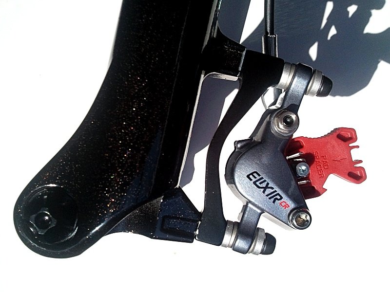
2010 Elixir Mag CR brakes 185mm (F) and 160mm (R)
Hope Pro2 QR15 front hub
DT Swiss Comp Black Spokes
Gold Ano spoke nipples
Velocity Blunt SL 29" rim
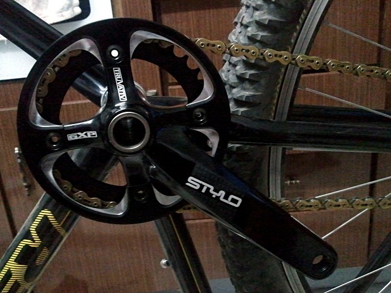
Truvativ Stylo GXP 1.1 cranks, with score of the week, an upgrade to SRAM Black Box Ceramic BB
Surly Cogs
Yet to come:
A rear wheel built up like the front wheel, but with a Hope SS hub.
XTR BMX style clipless pedals.
New tyres, maybe Maxxis Ardents
First photo is the bike, pre-upgrade.
Second image is before cranks
Second last image is the new cranks.
Last image is the Elixir Calliper


- Login to post comments
- Bookmark & share
Oh yeah, I did my first ride on the bike yesterday (Pre cranks) at Jerra Single Track, just outside Canberra. Besides the lack fitness the bike went really well. Suspension is way more plush than my Revelations which were on the Bullit. Way stiffer as well, with the QR15 system, the bike tracked really well through tight rough ST at Jerra. Only drawback, if you could call it that, is the fork topping out. Not sure if that is what the negative chamber on the revelations prevented.
Did a little lap today. Here is the Track map. I tried out my Android phone as a GPS. It doesn't work too well in the pack, so O am looking for a holder.
Very similar tack at pretty much the same time... I cant remember seeing you out there though.
See mine here http://www.sportstracklive.com/track/map#db0984/...
I heard cyclists behind me and saw some in the distance. There were lots of people out at that time, so we could've been lapping at the same time, on the same part of the track. Mind you, you were moving quicker than me.
How did you carry your phone? Was it in your back or on a mount? I am looking for a quality mount for my phone.
Yeah plenty of ppl out making good use of the weather before it turns to shit. I did however came across 3 riders moving in the wrong direction between seuss land and snakes and ladders. Then across 2 groups of 3 riders riding back up jumping the gun. We really need to get some direction arrows and trail head signs out.
I carry it in a mesh pocket at the top of my pack, so i still get good reception. I have an iPhone 4 and use the app "Motion x" not too sure if its available on the android phones?
I thought climbing, jumping the gun is Kosher. Actually is has been in all the years I have been riding it.
I came across a lady and man, that had just descended Snakes, as I was about to climb it. I also saw someone go past as I was nearing the top of snakes. He was heading down to the picnic bench on that really eroded trail.
I was considering one of these http://www.velotrac.com/, for my phone.
It could be, but going off the new trail map they plan to put out http://www.hmba.asn.au/files/GlenrockTrailhead2.pdf "double barrel" or "jumping the gun" whichever you want to call it, is one way.
The phone mounts look good, and definitely makes it easier to use on the go (rather then pulling it out of the pack all the time) but it seems really exposed to passing branches or if you do have a crash.
I think the GPS in the phone has more to do with the quality of the tracker. I know on my old Nokia would take up to 15min for it to connect to enough satellites and begin tracking (didnt matter if the phone was in or out of my pack). The iPhone connect within 10 seconds every time.
as yesterday the carpark was full at 1:30pm when I got there & the same when I left at 3:30pm, so there was heaps of people getting a G'rock fix & it would be a shame if someone went home sore'n'sorry from having a near head on crash!
Thanks Dean. I hadn't seen that document before. I didn't know that it was that direction. It seems that it is a nowhere track and the only way you can go is back up the Fire Trail (FT). It really takes the shine out of a loop, having to finish up the FT. Knowing that now, I will finish unhappily up the FT hoping that one day, there will be a ST finish.
Signs are needed as I spoke to a guy from the central coast, who had no idea about the trails. I convinced him to download the map on his phone. Last time I looked at the board (which I noticed that it has moved from one side of the trailhead to the other (I wonder why?)), I hadn't noticed a trail map on the board. That would be handy as well.
What is with all the name changes on that map. I can understand [Sh]It Happens, But jumping the gun being called Double Barrel, After the Watershed, being called De Luge. No distinction between upper and lower Kenny. World cup is named as Easy way out, which has jumps on the downward path. How does that fit in? As I have used it in both directions. I also notice that Snakes and Ladders, extends all the way to the Quarry. No issue with that, but it was 2 different trails before. Simplification works in this case.
An issue that I seem to find with this map, is that if you follow the trail map and climb S&L, then you are stuck in a continuous loop, as there is no option but to head to the start. Maybe they could reopen the trail between Easy Way Out and the easement trails as a descent trail. This trail basically comes out at that junction on Easy way out.
Is Workers, what is referred to as Tip Track?
Six Shooter's direction, appears to go against the direction of the jumps, as well. Finally there is no direction on Twisties.
ride back up lower jumping the gun!-starts under powerlines just after twisties,just head down to left & singletrack starts about 50mtr past steep section & it will bring you out at the left hand turn on the start of kenny's-just down from sign at start.On the map it is called 'reload'
I always remember that as a descending trail. Has that had any work done to it? As I remember it being fairly straight with a couple of step drop downs, which would be adverse to ascending.
So where does that leave Twisties? It goes against Pump action. It is a bit confused trail in that area, IMHO.
as it is a good way to really make ya knackered-log step ups are easy
Either way, unless you head back down Kenny's which puts you in an eternal loop, leaves you not much option. Not that I am complaining about the trail, it just seems that if you follow the current track plan, it doesn't really give you any options to extend past that one basic loop.
Log step ups are easy with experience. But I will have to check out the trail next time I am up there.
Why did the sign get moved? its thrown of the feng-shui of the trail head!
Not sure, but it doesn't seem to make sense. It now faces away from the way you would naturally come up to it. I didn't even stop to look at it this time as it is now annoying to look at it.
There must be a reason. Sammy/Empy?
No worries Mark. I think the idea of "DB" or "JTG" is to then head down Twisties then take the easement trail back up to reload to do Kenny. Alternatively you can do 1 of the following 2. Cross the easement trail and ride through "Pump Action" or "Quarry 1 & 2" (whichever you want to call them) and come back out onto Gun Club Road, Or just head straight up the easement trail onto Gun Club Road. From here you can head down 1 of the 3 (i think there is 3) trails on the south side of Gun Club Road (these trails do not appear on the map, and i know 1 if not 2 turn into the so called Downhill track, so be careful) You can also head down the really eroded trail to the picnic bench.
This said if you park at the top near the towers, you always have to end the ride with fire trail. One of the things i love about riding at Stromlo is that pretty much whatever trail you ride you always end on single track. Speaking of which are you from Canberra or lived down there for a period of time?
I know the DH trails. One was called Gap Creek or Gap Jump. I will not be descending either of those trails, as they are the trails that NPWS have lots of issues with and are trying to close. This is where the old trail that I mentioned earlier coming out on that Junction of Easy out and the unnamed trail from Fernleigh, would be good as a descent. I had trouble finding the start yesterday, but I can still vaguely see it.
I like the idea of JTG and up Lower JTG, then on to Kenny's. I will do that next time. LJTG, should be fairly tough on the step ups on the SS though.
The discussion about the new trail map can be found here http://glenrocktrailalliance.com/node/20842
I think it was still in draft form and needing some work. The reason for the name changes i think come partly from the new work being done by world trail and partly from NPWS.
I will take a look now.
There were a couple of workers out there this morning digging new holes back on the original side, so it looks like they are moving the sign back.
Or putting up the new Trail Map!
They wanted to put a new sign in and rather than ditch the old one they agreed to move it to the otherside is what I remember being said.
That would make sense... but why not put the new sign on the other side???
Probably as it will easier to see, because it is the way you ride in.
Im sure your right Macr
Call me old fashioned but i liked the sign where it was.... if i crash next ride im blaming the sign!!! its throwin off my mojo
Gets precedence over our noticeboard so it will face the entrance.
Ranger - Tiffany - wanted to ditch it altogether and have us use the back of the new sign, so I'm not sure how it will end up yet.
With the trails. The smaller loops along Gun Club Rd. are meant to be a 'stacked loop system', you can ride 1, 2 or 3.
There is a better version of the maps on the 'Maps' tab on the home page. There are newer versions to come.
To explain;
The first is down (or East) on Double Barrel then up (or West) on Reload.
The second continues from the end of Twisties, you go up the easement to GC rd. then through Muds, going east on the return trail not the jumps, then out to near the Tip Site. You can then return (go west) via. the 2 quarries (Pump Action) and back to the easement where you can continue back onto Reload.
The third one is to go out onto GC rd near the tip site, go east to near the big quarry then enter at the far end and ride the berms in the Tip Site going west, which brings you back to the lower 2 small quarries and the return to Reload.
So you are 'stacking' the small loops onto each other.
After that you just keep doing loops or head out onto the main loop - Kenny's trail, in a generally clockwise direction.
Make some sense?
Anyway the signposts and maps are on the way and it will all make more sense then.
Sorry. I could not figure out how to link the full size image
[Mod. fixed images]
The engine behind this forum is pretty average, unfortunately. Not very intuitive. I give it to you for going to that much effort to decypher the coding.
Great to see the new signs up. I will check them out this weekend, hopefully.
I've got some photo's I'll post up soon.
On the photo posting issue, once you have loaded the photo into the database, use the code
[image:XXXXX size=inline]
replacing the XXXXX with the photo number in the url for the photo.
Macr, on the trail name issue, you might need to go back and look through the forum on the trail name history. Youve been missing for a little while and a lot has happened. Probably quicker for you to have a look than it is for us to guve you a run down.
Here is a photo that I took in the backyard today.
And the Niner YAWYD Top Cap, which allows you to fit your Beer Cap of choice. At the moment it is Tripel Karmeliet.
Just wondering how many teeth are on the front and back cog's of the rottweiler?
cheers
32:21. It was set up for Jerra trails. 32:18 on 29er is equivalent to 32:16 on a 26er. I usually ride 32:20, as I am fat, unfit and old.