You are hereForums / By Discipline / Mountain (off road) / By Location / Australia / NSW / Newcastle & Hunter / Killingsworth MTB Questions
Killingsworth MTB Questions

I have never been MTBing at killingsworth but would like to go and try out the trails since HMBA are hosting races there this year. I have a few questions about the track:
- Where does the track start?
- Does the track go in a loop or are there separate tracks (like glenrock)?
- Are the tracks sign posted?
- How technical is the track?
- How many km's is the track about?
- Login to post comments
- Bookmark & share
Tags
The trails are not signposted and there is not set direction.
as far as difficulty goes, harder than awaba in spots, bigger climbs if you go to the northern end. Killi is great, it all just flows perfectly and has a nice mix of fast sweeping turns anf tight tech sections. It is one of the best places you will ride.
You could do a 20km+ ride in there without riding the same trail twice. Best to just go in an explore.
Sammydog, I'm interested in riding there too. I get up to that area frequently and I have always wondered about trying this trail but don't know where the trail is and where it starts. Are you able to clarify please?...or is it 'unofficial' riding these days ;-}
raced there 5 or 6 times. never rode the exact same track twice. Loved every one of them...
exit the F3 freeway at the Toronto exit-turn right over freeway then just after bridge turn left & follow this road for about 7km's til you get to the turn off on your left to Killingworth(it is called the Broadway) & follow this near to the end-then turn right go past the old pub just a bit & to your left is a dirt track which goes back under the F3 & swing to your right where there is a flat open area that used to be the carpark or park just down from pub & ride in.
Here RobbieO's explanation on Google Maps: http://goo.gl/maps/ra2KQ and at the end of the route turn left on the dirt track to arrive here http://goo.gl/maps/IQCXs
But note, I never been there.
Last time I heard this track had been closed to the public. Does what I'm hearing here mean that isn't the case any more and anyone can rock up and ride any time?
We should add this info in a more permanent place if that's the case.
Rob, i dont think its a mountain bike park yet, its a great place to ride, and people who can find it, will. I ride anywhere there isnt a specific sign that says tresspassers prosecuted, or no bike signage. I always thought it was closed off to the club because of multiple land holders - this seems to be fixed for this year.
Ever since the club had to move, people have still been riding it, its just that maintenance fell to only a few locals and some big storms washed out so many bridges, the number of riders declined.
BTW Robbie, Killy fails number one bogan test - teenage mums with nose piercings ;)- more of a country town to me
You won't find any washed away bridges, they have all been repaired and are probably better than when the club raced there.
You can try and follow this. Good luck though:
http://www.flickr.com/photos/51481863@N05/816812...
Rob,
The land is managed by the Hunter Development Corporation (a NSW Govt Department). When HMBA used it as their home track, there was strong rumours (actually more than rumour) that the land was going to become National Park. the western parts have since changed tenure to NPWS.
Anyway, given the complete disregard for cycling that the NPWS had at the time, HMBA set up awaba rather than being left without a track. Np one ever wanted to walk away from what was an awesome network.
After leaving, a crew have kept the place maintained, fixed all the bridged, basically done an awesome job.
HMBA of late has been trying to spread racing around (Dungog, Singleton, Paterson, etc) to add variety to racing, so we have made enquiries about killi and have in principle OK to race there again. Hoping to chase some more confirmation today. We have submitted trail maps, insurance, etc just waiting to find out if any trails are off limits due to mining activities below.
Is it OK to ride there at other times? technically there is no permission, but it looks more like a blind eye is turned to recreational activities in the area. So do so at your own risk.
Just wondering if you would share a gppx or kml file for your map? Cheers, Dave
Does this give you what you want?
This is a great ride. If you have strava premium i think you could download the GPX.
http://app.strava.com/activities/29071231
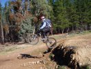
I live at Killingworth and ride the trails on my mtb semi regularly. There is some sweet singletrack, fire trails and remnants of the old downhill track. As already reported, the bridges have been fixed and the trails are in the best condition I can remember. You can ride a relatively non technical loop, or you can throw in some harder sections if you are up to it. On weekends there are plenty of dirt bikes out around this area (sometimes me), but not all of us ride on the mountain bike trails. Early mornings and weekdays are the best time to ride to avoid the brain damaged dirt bike riders and 4WDers.
Thanks for the link. Should work fine,even without premium you can export gpx- http://cosmocatalano.com/strava/export/index.html
where does the downhill trail start? and is it in good enough condition to ride?
I'm not familiar with the DH but have figured out roughly where it is. Nothing is marked so pretty difficult to find your way around without some help.
The DH is a Strava segment though so if you have a smartphone/Garmin then you should be able to navigate to it.
there was actually around 4 different DH trails that were used by HMBA for racing. All except one started at the same point and they branched off in various placed. Only the long (and short short) track ended in the carpark, the other two ended on the yellow brick road.
4 dh trails? are they all still there? i found the one on the map c3024446 posted.
I would image they would still be there, I haven't ridden out there for years. The state track was the best of the bunch, although also the shortest.
do they all start in roughly the same place?
They all start in the same area.
thanks
for anyone interested, the bridges are damaged, rideable but sketchy. Thought itd be rude to not throw a heads up.
ill watch out for that when i go there haha.
Thats a shame for the trail fairies, I heard they had replaced all the sketchy old bridges with new ones. Mind you, back when we raced there bridge replacement was pretty common. The ground is so sandy that the banks just get ripped away.
yeah if any fairies are reading keep me in the loop i live real close and now ive got an xc bike again i only really like ridin killi or the wallsend minmi single track stuff so ill be keen to come help
haltz, not sure the fairies are on here. I'll get a contact for you if you want it.
Just to clarify, these 'bridges' in question are they in the xc trails or somewhere else?
This would mean the recent bad weather has done the damage?
I'm guessing its those bridges, and significant storm would wash away the original ones.
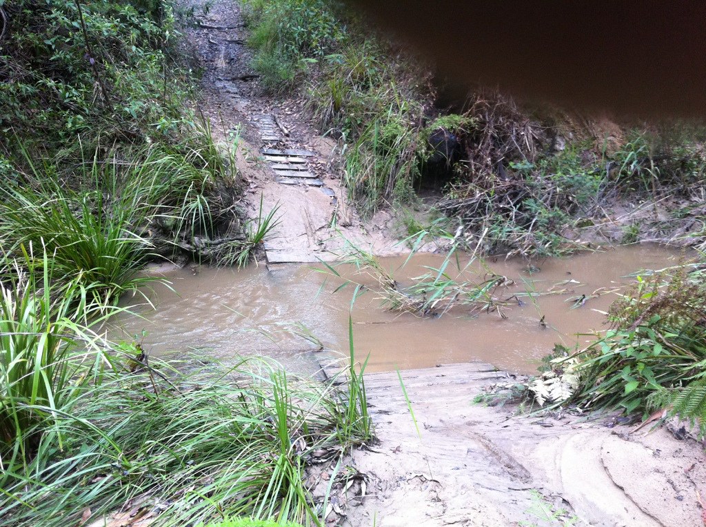
yeah i rode there on thhhhhursday i think it was, tracks were nice and tacky few puddles but plenty of room to get around but yeah depending on what way you like to go i like to go right from the car park and head i guess towards sugarloaf along that front nice piece of rainforesty bit, the bridge in there is there but structurally no good, stayed out of the piece of track back from there with the longer bridge across the sandier wider creek, being lower and wider im guessing it may be in worse nick
So two of the bridges need repairs. The long one is perfect still, it's only the one that runs parallel to the power lines which is stuffed. Other is a minor issue because the pallets weren't tied down properly.
Here is the main broken one, and the potential solution. This will be pallets laid across logs which have fallen already (he doesn't chop trees down!)
I'll be the representative of the fairy on here i guess, he wants to remain anonymous for some reason.
Is the top one the pig track?
I'll dig up some photos of the damage from the Pasha Storm, there was debris 2m up trees in that area.
Yes, that is pig track. I have worked out how to put photos on here now, might put up a killy bridges collection!
Bigger resolution here
Trails with names that we know them by (actually call pig track the bumpy track) Any help with actual trail names would be welcomed.
Pallet bridge on Wasp's Run after last years big storm. Held up well, still in good condition after the last weeks' deluge
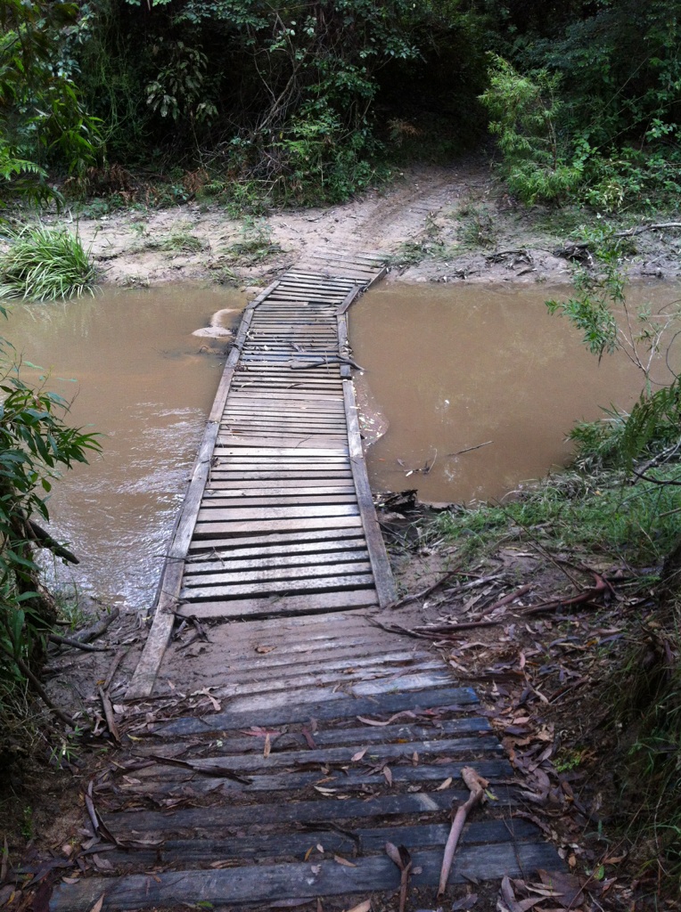
Example of a pallet bridge, this is on Sucker's Run, replacing an old, dangerous wire bridge
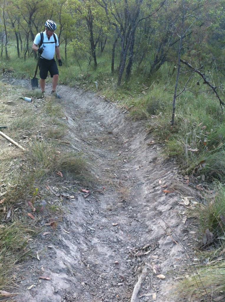
Fixing a motorbike rut on Sucker's Run into a nice chutelike track. This is not me, also, the man you see pictured has become alot thinner and faster over the past 3 months since we are training for the Mont.
We call this Mick's bridge. Still in perfect condition after the storm.
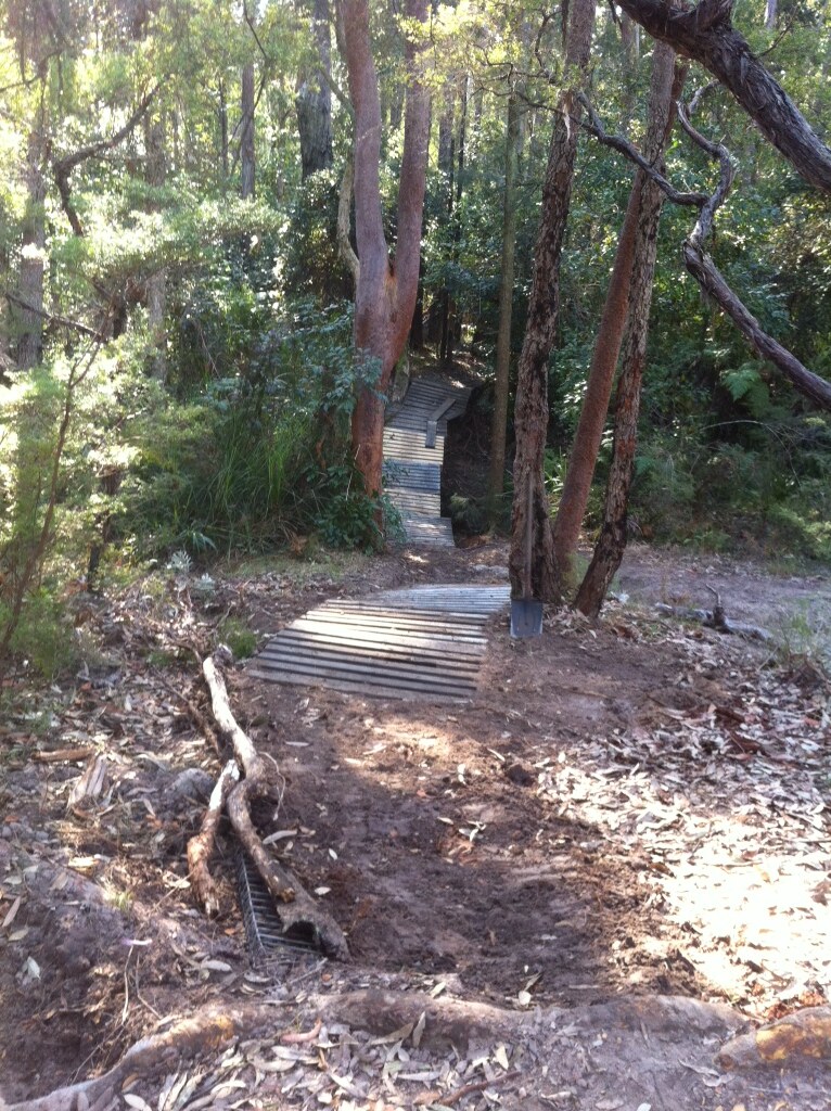
Another pic of a short pallet bridge holding up well after the storm last year. Still standing after last week as well.
Yeah that first pic is the one I was talkin about, you can still ride it, probably actually safer than walking down it on cleats haha well let me know fairy represent when yas rebuilding and if ya want a hand
Went out to Killingworth and had a great time riding on the north side of the easement, the south side was basically swamp.
Going off the map posted by c3024446 I found Sucker's run and the remnants of the downhill trail(more like trails as there are bits of trail everywhere). To those of you that know that trails I have some questions 1) is First st climb just the 4 wheel drive trail/mess up the hill at the end of suckers run or is it a single track that I missed? 2) is yellow brick road a single track or just the fire trail?
Any help with these will help me to orientate myself for next time.
Yellow Brick road is a fire trail. The short DH course comes out on this.
If you rode up the fire trail all the way, you missed some single trail. The single trail went straight up the hill from the easement and then went to the left of the DH berms. Eventually it popped you out onto the fire road mid way up the DH trail. there were a few options that lead down to suckers run, they are likely over grown and were only ever uncovered for State Rounds. Further up there was a fire road descent that came back down the far end of suckers run.
Yeah, that first street climb is just a 4wd track. That was an automatic name that Strava gave it.
I guess I should have been proactive and put firetrail in a different colour!
Thanks for the info sammydog makes things a little clearer.
Is the single trail up the hill you mentioned the one that at the easement starts basically where the long DH trail (or at least what I think was the long DH trail) ends? there was a single trail up that started off the easement, the long DH trail crisscrossed over it a few times then the as you went up hill the DH went to the right over some rocks and the single trail went left.
Also thanks c302446 for the info, it is all starting to make more sense.
Hate to be the bearer of bad news but I think I'm the only one silly enough to have been out there but the beautifully rebuilt bridge is down again, still rideable ya just need to carry ya speed to pop up the other side
natural cause or did somebody purposely take it down? and on which trail?
Natural,
Water got up pretty high after all that rain. I may go check what is left out there this afternoon.
Oh, and I think it's the pig / bumpy track trail
Its funny you know, up until the pasha bulker storm in 2007, we rarely lost bridges.
Post storm, the way the water ran in there was different. There were water billabongs in places that were always dry and the creeks seemed to flow faster. I can remember replacing the pig track and wasp loop bridges a number of times.
Shame the new ones went as by all accounts they were the best bridges that have ever been out there.
Raced out there for a few years xc & dh. (I'm sure my DNA is still scattered over the state track). I'll have to get back out there. The old wire bridges, that sweeeeet rain forest section. The electronic gates racing in the dh state series. Ahhhh the memories... I just had one of those little moments.
The rain we have just had, has certainly left its mark in a lot of places - need to be a bit careful riding as fast as you usually do on tracks you know - twice yesterday I came upon deep ruts in nasty spots that required some sphincter tightening, and then ruts were non existant 2 weeks ago.
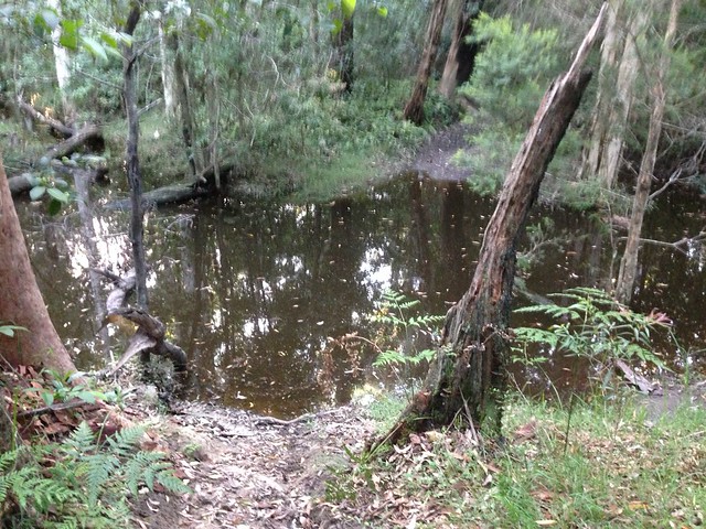
The place is just trashed. It had been dry for a while, and was fun and fast> Now, everything is more exposed, lots of sand around the creek crossings, half the bridges have been washed away, and motorbikes have rediscovered the tracks.
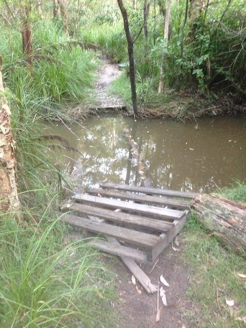
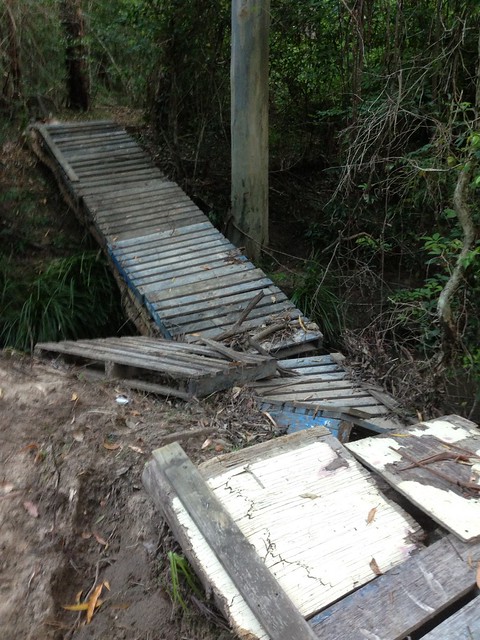
The Long Wasp's track bridge is still there, Pig Track's new one isn't,
Some pics from yesterday:
No more No Fishin' Bridge
New Lagoon on Wasp's Track at the big dip which shows no sign of emptying soon. This Lagoon actually has flooded 3 sections of the track and has made Wasp's Track impassible.
New Pig Track bridge which is cactus.
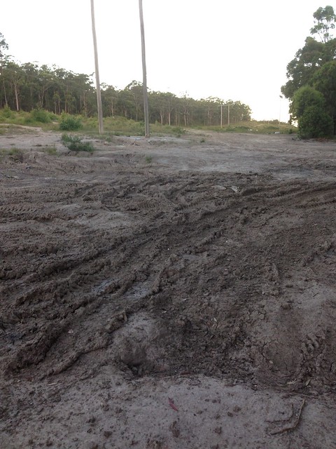
Someone taking advantage of wet conditions to completely fk up the Main Camp Area. So now Main camp looks like this everywhere, and also has a giant rubbish pile. Also, on the road into maincamp, there is HEAPS of dumped rubbish, even what looks like tin from an old roof. Some of the rubbish was just dumped in the middle of the road.
Seeing all this yesterday was quite dishearting. But bad weather and dickheads are part of life I suppose.
why do people have to mess with it. i know its partly weather related but still people dont have to be complete idiots and do stuff like this.
How's the f#%kin rubbish piles on the way in! The pieces of shit arnt even dumping off the side of the track anymore just right in the middle of the road, yep that'll do.
the place is chock full of asbestos as well. I'm surprised it hasn't been shut down.