You are hereAnything Else / Hill Comparisons
Hill Comparisons

So... what with being a nerd and all, I knocked up a small script just now that extracts the elevation profiles between two points in a GPX file (an export from MB will do the trick).
I thought it might be fun to do this and show certain hills we ride, you know - so people can get an idea of the challenge before doing them.
I can think that several of the Cascades climbs should be on this, Heartbreak hill at Manly and various others. Suggestions are welcome, comment below.
And then you get to the monsters! 
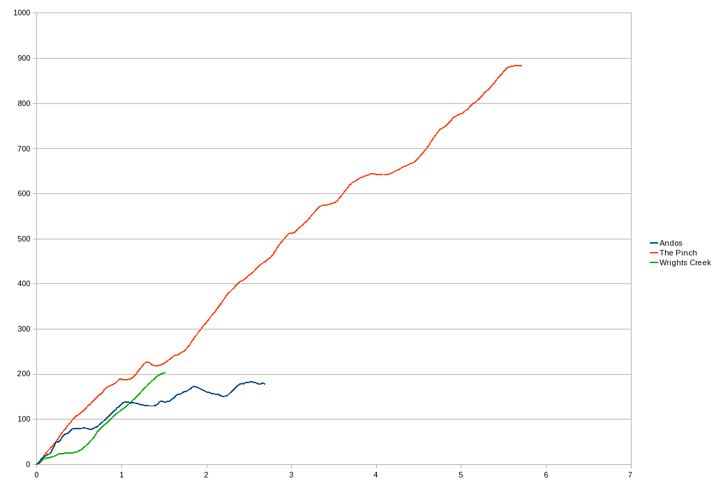
This rough sample shows the comparison between the climb from the creek crossing at Andersons to the gate at the top (in blue) with the first Climb of Dirtworks last couple of years - Wrights Creek (in green). Now these are pretty nasty, but look how feeble they are next to The Pinch in the snowies (in Red). Hmmmmmm... lucky we were riding down The Pinch is all I can say! 
Oh, vertical metres up the left side, Km along the bottom of course.


- Login to post comments
That is awesome. I would love to see some of the local ones in comparison as they all feel like monsters when your heart rate is touching 200 bpm and you don't have anything left in the tank.
But I love your work mate!
Should be interesting to see all the other 'famous' climbs on one graph...
when max heart rate is 220 minus your age i think that id be well dead at 200!!! mind you, i got a nice compliment from the monitor a few weeks ago saying i was only 29! either ive a very strong heart or it was chatting me up and reducing my age by about ten years?? stuart! no need for reply please! or you paul.
To be the one to have cyber sex with his HRM...
200bpm or close to it is not uncommon for me. 220 minus my age (33) says my maximun should be 187. I beleive 220-age is only a guide so when people are starting to exercise they don't go out and kill themself trying to find their maximum. Its not that uncommon for me to be around 194bpm going up heart break hill at the dam. I know a low resting heart rate can be a sign of fitness, I also thought the maximum rate wasn't important (to a degree) but the less time it takes to drop after exerting yourself was more important.
Rob,
That's cool - the local hills are going to look lame.
To put it in perspective is there any chance of getting one of those infamous Tour De France climbs as a comparison like L'Alpe D'Huez or Col du Tourmalet.
I think you'd be surprised... the famous Alpe d'Huez climb is only 13.9Km at a 7.9% gradient (692m vertical) according to this:
http://www.letour.fr/2006/TDF/presentation/us/pr...
I've driven up that road, it is rather steep!
However, the steepest climb appears to be on the Morzine stage: Col de Joux-Plane ascent of 11.7Km at a 8.7% gradient (1010m vertical).
Pah!
It looks like its about 15% grade!
Funnily enough, when we got to the bottom not one of us even considered trying to ride up even a tiny section of it. I just don't think it would be remotely possible. I mean, just look at the size of that thing!
I tried last year but all the people walking get in the way I got about 75 meters before it got too crowded and I had to stop and walk I will give it a go again this if I get a bit further I will be happy.
Top job Rob, I wonder what's next that will amaze me with what you do/are capable of
How about this then, an interactive page to compare/contrast hills at will:
http://nobmob.com/hill_profiles
This will get a table of vital stats under the graph in the end.
You notice that the individual hills are content types in their own right and can be discussed like any other, Andos, for example:
http://nobmob.com/node/4501
Eventually everyone will be able to post a hill, just specifying an MB trail they've found it in and the GPS co-ords of each end. Will do that later-ish.
You like?
Now that's even more impressive
Demoralising.
I just compared "Heartbreak pimple" to "Wrights Creek" - I need to do a heap more training.
Excellent work Rob
I'm very interested in grade (as big hills hurt). When i read motion based data I click "Elevation" and then check the "Display Grade" box. Thats the closest indicator I could find so far.
where is this 'Pinch' they speak of?
The Pinch runs down from the range of hills South of Thredbo to Barry Way. We did a nice ride there in Jan:
http://nobmob.com/node/3749
And yes, that descent is a stupid as it looks!
How about adding Brooklyn bridge to Pie In the Sky?

& may be Galston Gorge, Berowra Waters & Bobbin head....
They are all good climbs.
That would be good to compare profiles and they can be done on all types of bikes...
Good grief!