
You are here
nobmob.com

Quarry Road Track (Berowra Valley) update for 27 Jun
Track was mostly dry today, just a small amount of runoff/ standing water. I made the status "Amber" to remind everyone that officially you need to gain permission to ride this track, because it passes through the rifle range land. The guy who issues the permits told be that as long as you're off the track by 9am you're ok (they don't do any shooting before 9am).
Do you have more information?
If you've ridden here lately please add a more recent report. This will be useful even if the condition is the same as updates expire after 30 days.
Please do not post comments with such information - post a new update with the link above.
Please do not update this post with such information - post a new update with the link above.

Please! Stop riding Bantry Bay Engravings Trail: The selfish few threatening new trails
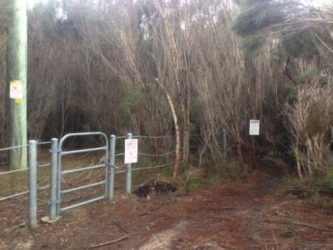
These pics were sent through to us showing that people are still using the old engravings trail at Bantry Bay and now a new exit down the fence line by the new estate.
If you are riding this or know people riding here please stop. NPWS has gone to a huge effort and spent a large sum of money to give us the mtb community Serrata and Gahnia trails to replace this trail.

Manly Dam update for 27 Jun
Officially closed as we found out this morning when we got to the school car park. Rode the section from here to the road and it was a bog. The little section behind the houses with the playground just before the golf course entry single is the worst I've ever seen it. Don't know when all the rain came down. Sure a deluge Thursday eve a week ago but never thought it would be this wet. So instead we rode the road to the parkway where the fire trail on the Bantry side is a mess in places, Possum is a bog and KC just as bad. We did ride Ghania which is in good condition.
Oh and Austrian Enduro has been closed.
Bit of a waste of time really; I wouldn't bother even thinking about for at least another week and that's assuming no rain.
Do you have more information?
If you've ridden here lately please add a more recent report. This will be useful even if the condition is the same as updates expire after 30 days.
Please do not post comments with such information - post a new update with the link above.
Please do not update this post with such information - post a new update with the link above.
Old Man's Valley update for 27 Jun
Council website says "open" but Lava Flow is very wet in places and in my opinion should be closed. I'll be staying off it for the next few days. All other trails are dry.
Do you have more information?
If you've ridden here lately please add a more recent report. This will be useful even if the condition is the same as updates expire after 30 days.
Please do not post comments with such information - post a new update with the link above.
Please do not update this post with such information - post a new update with the link above.

No more trail closures!
With all trail closures of late and inaction from some land managers. Tell the government what you would like in mtb resources.

Please Update Trail Status if you Ride on Saturday
I am looking to head out to Old Mans Valley, then St Ives singletrack, duckholes and Centre, Cascades, Possum and Manly Dam on SUNDAY morning so looking to get an idea if that is daft and I should stick to the road bike.
Old Man's Valley update for 26 Jun
I rode OMV today. It is very slippery where the sun hasn't been able to dry out the shaded trails. The bridges are quite slippery too. If it doesn't rain tonight then the sun and wind today should improve things quite a bit.
Do you have more information?
If you've ridden here lately please add a more recent report. This will be useful even if the condition is the same as updates expire after 30 days.
Please do not post comments with such information - post a new update with the link above.
Please do not update this post with such information - post a new update with the link above.
Nearmap help
Does anyone have access to Neapmap?
I need to look at how a track has changed between 2002-2010-2012-2015?
Bantry Bay ride-able 27/06?
We had a decent amount of rain on the coast yesterday and into the night but with a full day of sunshine today will Bantry Bay be ride-able tomorrow? What do you guys think?

NPWS Map of Bantry Bay Trails with Planned Closures

Looking at the Garigal National Park website it states that closures are planned for unauthorised tracks and notes 2 tracks being (1) Natural Bridge track to Davidson Park and (2) Seaforth Oval to Natural Bridge track. See http://www.nationalparks.nsw.gov.au/visit-a-park...