You are here
bmorc.com

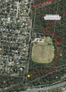
Knapsack Meeting Location - Southern end of Barnett St
Knapsack Build Day - May 23rd
The meeting times are 'ready to ride'. If you need time to prepare equipment then please arrive a few minutes earlier.
Southern end of Barnet St, (below the oval).
A small area for parking is available opposite to the gate across the road
Start at 8:00am at the southern end of Barnet St, (below the oval).
Plan is to try and complete the new track we started at the last build day. With enough volunteers we could also start the new alignment for the last closure we did last year. This will help establish the mapped XC circuit.
Blue Mountains City Council have hired Adrian from Synergy to lead the Maintenance days.
Trail maintenance will only run for 4hrs. To get the most out of it, please arrive early and be ready to start.
***EXTREMELY IMPORTANT***

Wylde MTB Trail update for 28 Apr
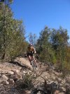
Wylde is definitely open. Did a few laps this morning.
A bit of mud here and there plus the odd derailleur wrecking tree branch still on the trail.
Other than that, pretty good.
Do you have more information?
If you've ridden here lately please add a more recent report. This will be useful even if the condition is the same as updates expire after 30 days.
Please do not post comments with such information - post a new update with the link above.
Please do not update this post with such information - post a new update with the link above.
Nepean Narrows Lookdown
The Nepean Narrows Lookdown is the furthest point from the trail head. The lookout offers a view on the Nepean River exiting the Mountains and into the Nepean Valley.
Riley's Mountain Lookout
Riley's Mountain Lookout has a 180° panorama looking west over the Blue Mountains. Directly below is views of the Nepean River. Directly across just over the first ridge is Euroka camping and picnic ground.
The Rock Lookout
The Rock Lookout. At the Trail head. Go Straight for roughly 100m. You will find a short walking track on the left that will bring you to The Rock Lookout.
Mulgoa Park carpark
A small carpark is available at Mulgoa Park
Mulgoa Shops Parking
Car parking is available at Mulgoa Shops
Trail Head Parking
Plenty of parking is available at the Rileys Mountain Trail Head.
Riley's Mountain Trail Head
Riley's Mountain Trail Head is found at the end of Fairlight Rd (last 2km is dirt road)