You are here
kml

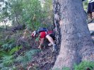
Colour Coded Trails
.jpg "Manly Dam in Google Earth")
Some of you may have noticed a whole heap of 'Track' content types popping up recently. This is as we will finally have colour coded maps shortly. All the KMZ files have been previously created by hand which meant the author (whoever that was  ) decided to draw the trails in completely random colours.
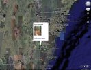
Soon the KMZ (well, KML file, actually) will be generated from the data in these 'Track' nodes on the site, meaning they can be colour coded according to type (firetrail, single track, etc.). An example of what this looks like is Manly Dam seen here. OK, sneak peak of full auto generated file here.
As a by product of all this we'll get some stats on Km of trails by type, location, etc.
And just a reminder of course, anyone in the Content Authors group can create a write up of an area worth riding in, and now create 'Track' content types too so individual trails can be mapped and discussed. There's more on that in the Content Author's Reference.
Full KML Demo
An example of what our all nodes KML looks like at the moment. Soon this will also include paths too and the old KMZ files will be retired. Well - as 'soon' as soon can mean around here!
KML Feed Enabled

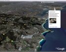
We're happy to announce that more integration with Google Earth/Maps is now complete on the site. The NoBMoB KML feed is now live (image shows it loaded in Google Earth). This is simply a way to show all the geocoded content on the site, which at the time of writing is limited to trail reviews (stars) and photos (camera icons).
Don't get this confused with the NoBMoB KMZ which has trails marked and only certain pictures shown.
When limiting this feed to certain categories it's also useful for pinpointing other stuff (like ride locations) in Google Maps. This is used to good effect on the rides overview page which now shows locations on a map.
Enjoy 
KML Demo
Small demo of what the NoBMoB KML feed looks like in Google Earth. This is simply a way to show all the geocoded content on the site, which at the time of writing is limited to trail reviews (stars) and photos (camera icons).
Don't get this confused with the NoBMoB KMZ which has trails marked and only certain pictures shown.