You are hereForums / By Discipline / Mountain (off road) / By Location / Australia / NSW / Blue Mountains / 6 Foot Track trip
6 Foot Track trip

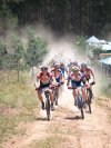
Depart Blackheath 8:00am on Megalong Valley road. Descend through rainforest to valley floor to farmland and forest. Great views of cliffs to the east. Turn right onto 6’ track after crossing Megalong creek. Fire road for a few k’s then turn onto single track across farmland, a few cows to negotiate and fences to climb over. Undulating single track through to forest, watch out for many cow pads make sure you ride up front. Single track through forest above river valley, spider webs, make sure you ride at back. A few technical sections and steps and gates. Get to swing bridge. Cox river in flood, do not cross. Had to take bikes across swing bridge. 2 people required per bike. Hold on to wire with one hand and bike wheel with the other. Go back across and get other bike. Cross the river if ok, do not use bridge unless have to. Climb steps, single track to campground. Start climb, some granny gear, some 1-5 stomping, mostly walking. Temperature on track is 37 degrees! Spot an 8’ goanna. Climb, climb, climb. Open paddock, say g’day to some guys building a fence. Climb more. Reach saddle over the top then downhill to Alum creek. 3 flooded fords to cross, thigh deep. Say g’day to some guys in a 4WD on a trip to the Cox River. Climb, climb, climb. Great views, waterfall. Climb, climb, climb. Reach Black Ridge range. Celebration as the mean ascent is done! Fire road undulating, great forest and views south. Come across pine plantation. We turned right, should have turned left. 15 degrees, misty and raining. Chasing eastern grey kangaroo down pine plantation forest road 42kph. Turn left down gulley. 6” deep mud track, you know that thick red clay stuff that clogs your tires and gears, No OTB’s here! Climb to ridge. Lost. No signal on iPhone. Bugga! Get compass and map out and head west to intersect with Jenolan Rd. Find Jenolan Rd and see J.C 16km sign. A couple of more climbs on the tar and then big decent into caves.
Arr 700pm. Break chain when riding up hill to Caves House. (note to self, lucky it did not happen on the track take chain repair tools next time). Next day, broken chain means bus back to Blackheath.
Took: Compass, Topo maps for Jenolan and Hampton, Iphone (battery ran out & no phone signals out there, use a Garmin or satellite based nav system)
Should have’s: Turned left at the right spot. Another litre or 2 of water. Registered with Katoomba Police and pick up a free emergency beacon. Adequate tool kit with chain repair. Maybe group of 4 would be better, just in case of bad OTB incident.
Stats:
Ride time: 6:20hrs - Max speed: 56kmh - Avg speed: 11kmh - Distance: 70km - Water: 4 litres (needed 5).
Lowest Elevation: 270 meters (Cox River) - Highest Elevation: 1250 meters (Pine Plantation)
Total climbing: about 2,000 bloody metres! - Temperature range: 15c to 37c – 22 degrees.
Smile: 30 cm wide!
- Login to post comments
On my to do list.
Maybe a BMORC trip?
if your planning another trip like this early next year, i'd be keen, been thinking of getting further into the mountains on a fun alldayer for a while!
Hey Ian, i have done this ride heaps of times, it is fun in parts, but you have to ride heaps and heaps of stairs, i will take you out if you want, there are a couple of real hard tech sections!
Ill take you up on that one day Todd. Might be an idea to wait till after summer though.
Blimey, you're a brave man to take your bikes across the swing bridge like that!
It scared the willeys off me when I did it & I was just walking across with a 15kg backpack.
It felt like the whole bridge was going to flip over at any moment due to my high centre of gravity.
But I s'pose it would've been much safer the trying to get across the ford with all the recent rain.
Did not want to turn back after seeing the flooded Cox River, the young bloke did very well. Yep bloody spooky alright, keep weight on feet and it was quite stable. Any weight on the cables up high and "a swinging you shall go".