You are hereForums / By Discipline / Mountain (off road) / By Location / Australia / NSW / Northern Beaches / Murrua Walking track in Nth Turramurra
Murrua Walking track in Nth Turramurra

Hey
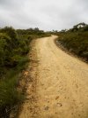
Just wondering if anyone else knew about this track? It is at the end of Murrua Rd (just off Bobbin Head Rd, on the roundabout just before the NP). It is a very fast track, which is for the most part flat, until the end where it is a steep, rocky downhill for about .5km (don't quote me). At the start it forks; one way has a bit of a wooden bridge (don't know if you can call it that) and is very rocky, quite technical, but very fast trail that joinds back to the main trail after most of the undulations, the other way is the main fire trail, and is subject to a few steep undulations. The maintrail is very wide, and mostly clear of big rocks. At the end of the fire trail there is a mains power line tower. Just behind it is a small single trail, take that, and at the end there is a nice rock to sit on and watch Bobbin Head, which you have a good view of.
Hope I am of assistance, and not hindrance.
Mitch
- Login to post comments
After going down the Terry Hills track it got me thinking that maybe this track isn't that long in comparison (maybe about 1/4, or from start/finnish to long track). It could just be an extra after doing a track nearby???
At any rate here are some google earth snaps:
http://www.cycloneinjapan.com/upload/files/81/Mu...
In this one it's the track to the left, the white bit at the end is the power pole, after that it's a short stint on single trail to the lookout. At the beginnning you can also see the alternative route, which bypasses most of the hills on the main trail. This trail is still fire trail, but it has a line that you ahve to follow, as there are some very big rocks on this track.
http://www.cycloneinjapan.com/upload/files/81/Mu...
Maybe a group ride down here sometime?
Mitch
Had a measure in GE, 2.84Km, so yeah, despite the steep bit at the end not too challenging, eh?
However, reckon you are on the right lines thinking it could be joined with other stuff. Take the Bobbin Head track on the other side of the road for example. That looks steep at the north end where it goes down to the marina. From there you can defo swing right along Cowan Creek and make a loop back to the start.
From the marina looks like you could also go left and cross Cockle Creek, then cross again and hit the path that runs back south at the bottom of the valley. It's marked as Gibberang Track and can be joined to Murrua but only with what looks like couple of Ks on the road.