You are hereForums / By Discipline / Mountain (off road) / By Location / Australia / NSW / Northern Beaches / Northern Beaches Trail Advocacy / Riders on carvings
Riders on carvings
Hi all
We have been asked yet again to remind people to not ride over the 'moon rock' carvings on the other side of the fire trail from the model aero club at Oxford Falls.
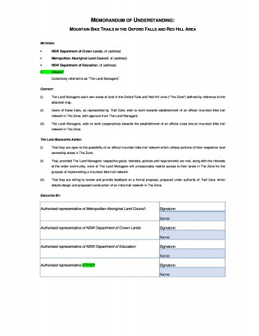
Unfortunately the previous board at the Metropolitan Local Aboriginal Land Council did not sign or progress with the MOU we drafted two years ago which was an agreement to work with other land managers to resolve trails and specific issues in this area. This MOU was drafted following in-principle agreement to proceed from all key land managers.
With government support we are hopeful of reopening dialogue with the new board and the other land managers. This will enable trails to be managed, sign posted and rerouted where necessary.
The draft MOU is attached and the meeting minutes in the next comment.
- Login to post comments


Minute summary:
In essence: "We don't want to work with you but would you mind spreading the word?"
Or is there an interested 3rd party?
Once again, Simon, your efforts are appreciated.
NPWS. I filled them in with the history of ongoing discussion, emails and letters with MLALC, MOU etc and agreed to put a reminder post up for people.
They still appear to be trying to turn the whole area into a National Park. This may be a good thing as it gets protected from development, just need to make sure there is a place for riders.
Using Strava we have tracked at least 2500 individual riders using this area, the vast majority keeping away from carvings. And about 200 walkers and runners. However we are not being consulted.
I have raised the issue that the biggest user group is again not being consulted with Rob Stokes, Minister for Environment, by email on 29 October 2014. I keep being reassured he will get back to me but am still waiting.
Some earlier work in 2008 by us through NobMob led to a Draft Plan of Management with actions to resolve rider access. This could have resolved the carving issues by creating new single track on Crown Land. However this Plan, as with the MOU, appears to have stopped too and become irrelevant as MLALC claimed the Crown Land.
Rant deleted.
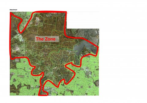
right smack bang in the middle of "The Zone"
http://www.realestate.com.au/property-residentia...
nope.. you cant ride on them, but you can buy them and build a house on them?
Not all areas within 'The Zone' would fall under the MOU. Only land held by managers that signed up to the MOU and then this would only apply to lots where connectivity is required to establish trails for public recreation.
Out of interest can anyone pin point the location of the lots in Obmals post? Surrounded by National Park on all sides is a surprise. Unless the government has already approved the proposed new national park without consulting stakeholders I'm not sure where this would be.
Main fire trail in from Beacon Hill opposite Maybrook Ave
That isn't surrounded by National Park unless the government has approved turning Oxy and Red Hill into one without consulting user groups.
PM sent
not sure how to post a google earth placemark
151.25536912266,-33.73256150906749,0
https://maps.google.com/maps?ll=-33.732549,151.2...
Thanks heaps for the PM and links.