
You are hereBlogs / Lach's blog / Myall River Track - Hawks Nest / Mungo Brush
Myall River Track - Hawks Nest / Mungo Brush

I tried to walk this track years ago, but it was closed due to flooding. So this week, I took the trusty Niner and an adventurous mate out to see what it was like.
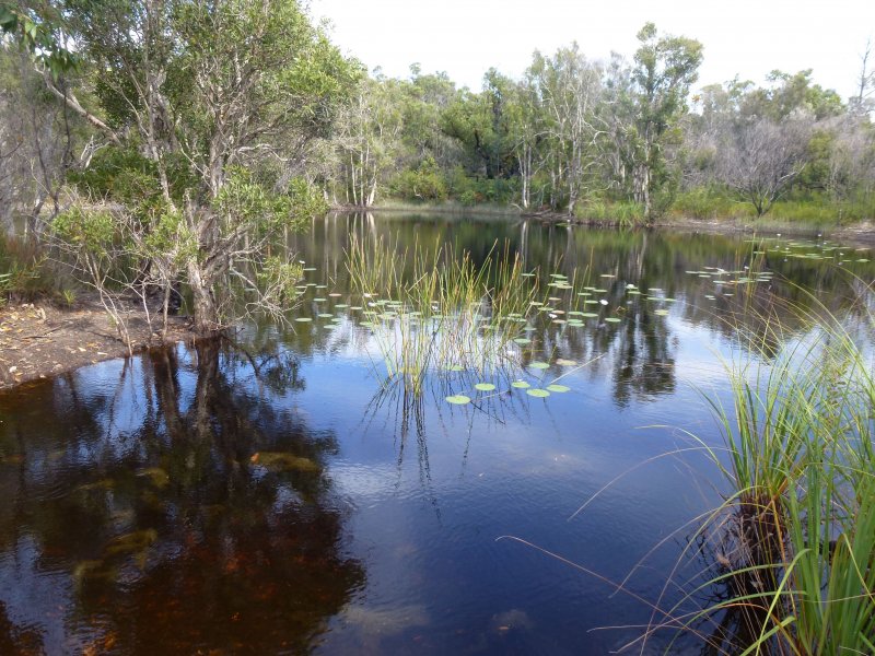
The track head is about 5km north of Hawks Nest on the road to Mungo Brush. On the left, just after the NP entry sign and map board. It starts as a gravel stabilised two wheel track running down to the Myall River, but turns right a few hundred metres in. The next few km's of two wheel track are a bit of a slog as it gets pretty sandy. A good track to ride on a fat bike or after a bit of rain (not too much rain, as noted above). Mostly rideable, but a couple of small hills caused the wheels to cut in too much and walking was required. As was a bit of balance work on the way down the other side. Not big hills, just small vegetated sand dunes. Passed a couple of sand mining water holes in this section (see pic) and saw a small snake and lots of dingo tracks.
After about 5kms the track heads back up towards the road and then continues parallel to it for another 5kms of flat, gravel stabilised track. A bit grassy in this section, which was a bit worrying after seeing the snake.... There was a also a creek crossing which looked like it had once had a road over it, but had been washed away at some stage. A few stepping stones suffice today.
The track then pops out onto the road for a few metres before heading into Brambles Green, a camping spot right on the Myall River. Again the track in here is pretty good (did I mention flat?), weaving a bit through palm and paperbark forests in what is a pretty damp area, with some large gravel consolidating some of the boggier sections.
At Brambles Green, the track is actually closed through to Mungo Brush due to damage to boardwalk structures that occurred in a bush fire some years ago. But we gave it a go anyway. Fortunately it was not too wet and we were able to navigate the mostly damaged first section OK, only to find that the track becomes almost non-existent after this. Took us a little while to sort out where it went and then we had another section of damaged boardwalk to get through until we got to where the repair funding had obviously run out. The boardwalk was quite OK after that, although with no usage in recent times, it was getting overgrown and had a couple of small trees down on it. The boardwalk was followed by a couple of hundred metres of gravel walking path, and then the track pops out onto the Mungo Brush / Tamboi 2 wheel track, for about 3km back into Mungo Brush campgrounds. This track had a few puddles but was generally OK (flat as well!), with some nice glimpses of Myall Lake.
After a brief break at the Mungo Brush campground we TT'd it back to Hawks Nest. Took us about 2.5 hrs to ride the 25 kms out from Hawks Nest and along the track to Mungo, and less than an hour to ride the unsurprisingly flat 20kms back on the road.
Strava link here: https://www.strava.com/activities/520624545


- Lach's blog
- Login to post comments
There's so much history buried and overgrown in that area, dating back to the late 1800's early 1900s before the railway and highways were put in, when water transport was the only way to conduct commerce.
For instance "Tamboy" caught my attention on your strava map. Google earth shows it as a fishing village. Looks like it is only accessible via water. Do people live here permanently? Do they have mains power? probably not. Do they have modern services and communications? Do they play the banjo?
http://www.pbase.com/elsiemaud/tamboi_fishing_vi...
Amazing the places you can get to by bike that you can't do any other way. Great fun going off the beaten track exploring. But you do have to be prepared.
.. there is quite a bit of history. Tea Gardens used to be what was called a "registered" port, with genuine waterside workers (wharfies) and large vessels calling, back in the day when timber was a major product from the forests surrounding Myall Lakes. There used to be numerous logging rail lines running down to the lake and logs were floated down to Tea Gardens for loading onto sea-going vessels. Much of the strip along the coast has also been sand mined at some stage. Tamboi has a track from the main road leading to the river on the coast side, but you need a boat to get across to the cabins. I think the photos on your link show some sort of manually operated ferry, but we didn't go out there and have a look. I could hear the banjos....
My family comes from the area around Taree. Dairy farming, dairy management, shipbuilding. Back when my cousin was alive we used to ride the old logging roads around he back of Old Bar, and some fauna tracks by the river that had been surreptitiously turned into singletrack by him and his mates (yes, 70+-year-old trail fairies - something in the water up that way).
It was exciting waiting 50 metres or so away from the trail entrance until the motos were out of sight before quickly picking our bikes up and wading through the undergrowth to where the trail actually started, and then doing much the same at the otter end to make sure we didn't emerge until the coast was clear. It felt like we were naughty teenagers again
Not many banjo pickers but plenty of farms dotted around. Unfortunately in a few places some tool with a monster truck type of 4WD has gone though after a period of heavy rain and flooding and dug massive trenches in some of the roads that have filled with black sticky stagnant water, rendering them impassable by regular cars or even 4WDs in dry weather. These are roads that have been on the map for more than a hundred years.
Sometimes you encounter the remains of old cars with massive trees growing out of them, and ruins. Makes you wonder who lived there, and why the dwellings were abandoned.
One night we were out searching for the fauna track and almost rode straight into the Manning River - the lack of reflection prompted my cousin, who my son and I were following, to realise something wasn't right and call out "STOP!" ... just metres from the bank. We narrowly avoided ploughing into the back of him and sending him into the drink!
I had no idea where we were.
Good times.