.jpg)
You are hereForums / By Discipline / Mountain (off road) / By Location / Australia / NSW / Snowy Mountains / Pilot Wilderness Ride
Pilot Wilderness Ride

Inspired by ride listed on this site, I'd been dreaming about riding the Pilot Wilderness from Dead Horse Gap to the Pinch Campground for years. A few weeks ago I finally got to achieve it and what an amazing adventure.
The story is too long to post here, if you are interested in reading the detail please visit my Pilot Wilderness blog posts
- Login to post comments
Tags
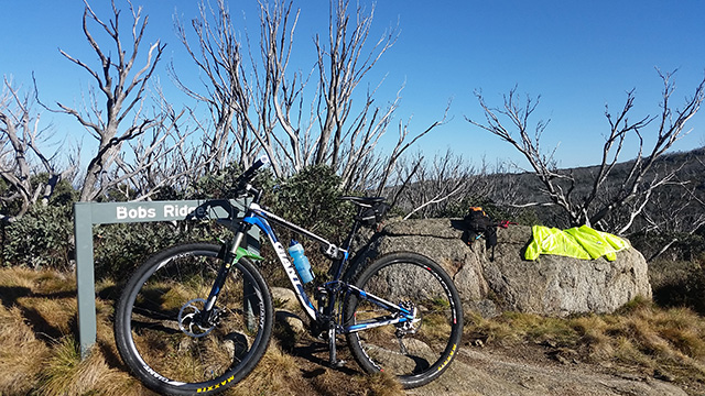
... it's a great ride out that way. have been there a few times and love Cascade Hut. Have used it to light a fire and warm up a nephew after he had a bad off on the way down from Bob's Ridge. That was the only ride I've done where the water in the tube of my Camelbak was colder than the water in the bladder....
Went out there in 2005 just after the fires and it was very sad, lots of dead trees and huge bits of bark across the track. Looks like it has recovered well. Last time out there was 2011, when it was looking a bit better, but it seems to have come back even further.
Ha I noticed the same thing about the water.
In the half an hour after Cascade Hut the regrowth often looks like an orchard (seen in the video). In many sections is so thick you couldn't walk through it as the trunks are so tightly packed (you might be able to see in the photo below). The tall grey dead trees, the thick green regrowth and the orange dirt make for quite a picture.
I'm not up to putting photos in these posts, but this is somewhere out past Cascade Hut in 2005
http://nobmob.com/node/53616
Is that a snake track in the dirt at 1:35? It looks like a big un!
A bit scary losing brakes on a descent like that. A quick calc in my head says that thousand metre drop is just short of a 17% average. That's like Cascades' Quarry Track for 6 kilometres!
Actually that's pretty accurate as an average. It gets much worse but also sections more like the 2 fun long track descents. It's next level no doubting.
The tracks when I'm stopped and freaking out I'd say are kangaroo tails, but I had the same thought .. Just too straight and not continuous for snake
Yeah that's unrecognisable from my ride. Is that the same ride as the trail database?
yep, it's somewhere out past Cascade Hut. Not sure where - pre GPS days. Just rode until I ran out of time and turned around and headed back.....
Mike and I road this over Christmas. It is such amazing country out there and i love that sense of adventure and going somewhere new.
It was pretty warm the day we did it, so staying hydrated is pretty important.
That descent to the pinch camping ground is crazy steep and long. We were descending and came across a group of brumbies as were descending. We couldnt stop and we spooked them and they started running n all directions up / down a 20% slope. Very scary in deed.
Last yeat i also did an out and back on the cowombat trail which is also a good ride down to the snowy river camping grounds.
Attached is our strava link in case anyone wants to download the GPX
https://www.strava.com/activities/459124713
Great stuff - good to see some othe like minded adventurers out there !
I did the ride to the Cascades Hut a couple of years back and would love to have gone further. I've heard the descent is crazy - I reckon it'd be more fun were it a gentler gradient over a longer stretch of time but anyway... At least you didn't need to ride up it!
Not sure that even you could climb the Nine Mile Trail Tristan. Its ridiculously steep and there are some really really long sections of near vert.
Dicko - I'd studied your Strava of that ride (prior to going) and was blown away. I was buggered driving out from the Pinch Campground, I couldn't imagine having to ride up it, especially after riding all the way from the LCR. The Pilot part of the ride was probably some of the easiest on your ride !!
It was a great adventure. The logistics take a bit of effort but its very worthwhile.
what software did you use for editing?
All in Google Earth on this occasion. I just exported Strava, converted to KML then marked it up in GE.
Generally I find Map My Ride easier to create routes from scratch, while MMR is a bit clunky it's forgiving, if you screw something up in GE paths its torture to fix!
It just occurred to me you were talking about the video
Premiere