You are here
nobmob.com

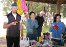
Thredbo – Easter 2004
The Cannonball Run, Kosciusko, Cascade Hut and back.
The day (Sunday) started out with a bit of rain but cleared up during the day. By 9.00am, all the men and children raring to go (there were about 6 adults and 7 boys under the age of 18 in our group). I was still hesitating, after being told in no uncertain terms by Colin "not to do it", but I signed up anyhow, kitted up in my full body armour and headed out for the skills session...
January 2004 Western Australia - the Munda Biddi trail
Justin and I rode the trail from Mundaring to Brookton Highway on the 16th Jan 2004 (a total of about 45km on the trail, and then 25km on the Brookton Highway to Kelmscott station).
We left at 8am and the first 10km was a breeze. However, not long after leaving Mundaring Weir we encountered the pea gravel, and from about 12km to 35km it was pretty hard going, especially in the heat. We had to get off and walk a lot, especially on the hills. We thought the profile map was a bit misleading. This was meant to be the "easy" section, but even the hills weren't as difficult to deal with as the gravel.

Rob

Rob somewhere near Morzine and the French/Swiss border.
Not quiet the northern beaches, but fun in the sun all the same.
Cascades in Google Earth
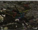
There are pictures and other commentary in the Cascades KMZ file, but turned off here for clarity.
Also see Cascades ride details.
Terrey Hills in Google Earth
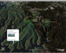
From our Terrey Hills interactive map.
They don't have high res images north of the Perimeter Trail by the look of it. Doh!
Also see Terrey Hills ride details.
