You are hereCascades / Cascades
Cascades
At a Glance
Cascades is a good test of your cardio fitness - lots of hills and not much technical stuff means easy riding if you have average to good fitness.
End of Wyatt Ave, Belrose - this is on the East side of Garigal National Park.
The Cascades is basically a deep valley area in Garigal National Park, on Sydney's northern beaches. Being sandwiched between St Ives, Davidson, Belrose there are alternate meeting spots at the top of Cascades track, St Ives and also end of Ralston Ave, Belrose (one street over from the 'regulation' meet above).
It's roughly 100 vertical metres from the creek to ridge top and has various trails running up and down this so be prepared for a lot of climbing. Luckily the majority of this is on firetrail and there's even a small sealed section to help you out (at the Davidson exit).
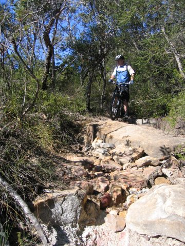
Although this is mainly firetrail, there are at least two single tracks I know of, and probably more. One of these is a technical downhill from the Ralston Ave entry area to Bare Creek Track on the valley floor. Let's take a look at the individual trails in no particular order:
Heath Track
The Heath Track is a fast firetrail that runs from the Ralston Ave entry down into the valley and Garigal National Park proper (you'll pass the sign) before becoming Bare Creek Track. Although it's fun, watch out as there are sandy corners to catch a rider out. The climb out on this one is, of course, a little tough, but good for training so a nice option.
Short Single Track
Unofficial name - this is a short but nice loop near the Ralston Ave entry. From those gates carry on down the road and hang a right off the road up a climb of a few metres almost at the end. Turn left (doesn't matter which one) and you'll see the path disappear into the bushes here. This is a nice warm up, but there's a tricky climb over rocks and roots after several hundred metres.
Technical Downhill
Unofficial name - when you are heading down the short single track there is one fork after couple hundred metres, left takes you to this downhill. It is overgrown in places and has big roll offs and rocks to contend with before ending up in the valley on the Heath Track. Note that close to the bottom of this trail is a 'T' junction. Very close to the right is a power pylon and it is in this direction riders should head back to the heath track for more cruising along the valley (turn left at the firetrail) or back to the top (turn right).
Bare Creek Track
Heath Track merges into Bare Creek Track shortly after entering Garigal National Park. Bare Creek runs along the East side of the creek, passing the first creek crossing (Quarry Trail) then another right turn which leads to another crossing. Eventually Bare Creek joins the Cascades Track here.
Quarry Track
From that intersection with Bare Creek Track cross the creek and start the toughest climb in this area (about 100m rise in less than 1Km). There's a gate near the top to rest at, or you can take 100m or so of flat stuff before another short push to the peak.
Ridge Top Track
Unofficial Name - for want of a better description, this trail runs from the top of Quarry Track, past the recycling depot and round to St Ives. It's all pretty obvious aside from the last turn towards St Ives.
Cascades Track
At last, an easy run! Start up by St Ives Oval and ride down this firetrail. Check your speed and watch out for the water bars, riders and walkers puffing and panting in the opposite direction. Carry on down the sealed section, past the Bare Creek turnoff and along the creek (and a couple of crossings) to the Davidson exit.
Lower Cambourne
There are two junctions on the downhill Cascades Run, Lower Cambourne is the second of these. Take this left turn for more downhill fun (although not as steep as the other options) before coming to a creek crossing and joining back up with the Bare Creek Track.
|
Water
There's a tap at the sports field on Wyatt Ave, about 200m from the trail head. This is particularly handy when travelling between Cascades and Oxford Falls. |
|
Parking
Plenty of parking on the St Ives side of Cascades by Acron Oval. There's also an off-road area right by the corner of Acron Rd/Douglas St that can be used. |
|
Toilets
There are toilets at the sports field on Wyatt Ave, about 200m from the trail head. |
|
Cascades from Wyatt Ave
(15.12Km)
Single track loop, down Heath, up Quarry, along ridge, down Cascades and return. Easy fire trail with 2 big climbs. |
|
Cascades from St Ives
(22.31Km)
From St Ives with 3 big, 1 small climbs. |
| Challenge | Distance |
|---|---|
| Cascades - Davison to Substation | 5.38Km |
| Cascades - Four Gates | 15.4Km |
| Cascades - Quarry Track Climb | 0.66Km |
| Title | When |
|---|---|
| Cascades Night Ride | 10 years 51 weeks ago |
| Cascades Night Ride | 11 years 1 day ago |
| Cascades Night Ride | 11 years 4 weeks ago |
| Cascades Night Ride | 11 years 5 weeks ago |
| Cascades - Social | 11 years 13 weeks ago |
