You are here
bmorc.com

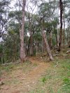
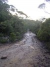
A Wet Morning
A cold wet morning near the narrow section.
As the drainage is so good and it is a fire trail its a good ride in various types of weather... the exception being thunderstorms!
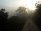
Views From the Trail
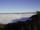
As the altitude of the trail is around 900-1000m while the surrounding valleys are up to 500m lower you can get these great moments where you are high above the clouds.
Phantom Falls over the start of the trail
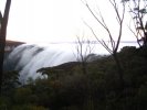
Phantom Falls over the first descent and climb taken from the very start of the trail.
Fog in the Megalong Valley sometimes flows over this low section into the Jameson Valley. Makes the ride that much more interesting.
Rough Descent
Top of the main descent to the narrow neck itself. Steep and loose with a sharp right at the end of this view.
Fun going down while very painful riding back up.
View near the end
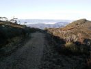
The view before the last descent to the lookout at the end. Trail gets quite rough and loose here.

Its funny what you can find on the interweb
Andy ... just huck it Dood 
That use to be one of my favourite bits ... on my way to itchy and scratchy 

How wide are your bars?
As the title suggests, I'm curious as to how wide people are running their bars.
DH "Stringline"
The approved Downhill Track at Knapsack.
Starts at the highest point on the fireroad and descends across "Lovers Walk" (note be careful here and look out for walkers!!!), then becomes single track all the way down.
Poo Farm Sniggle
Knapsack Reserve
At a Glance
A variety of tracks with a mix of firetrail and technical single track. Currently a bit of a maze which allows for creating your own loop.
Also includes a legal DH Track.