
You are here
bmorc.com

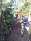
Knapsack Build Day - August
The meeting times are 'ready to ride'. If you need time to prepare equipment then please arrive a few minutes earlier.
Southern end of Barnet St, (below the oval).
A small area for parking is available opposite to the gate across the road

All are welcome!!!
Start at 8:00am at the southern end of Barnet St, (below the oval).
Plan is to finish the trail we started in June.
Blue Mountains City Council have hired Adrian from Synergy to lead the Maintenance days.
Trail maintenance will only run for 4hrs. To get the most out of it, please arrive early and be ready to start.
We will be trying to finish the new bit of trail we started last build day, with this complete we will then close the parallel trail that runs through the muddy bog.

The Oaks update for 17 Aug
Oaks and Red hands Cave closed due to hazard reduction burn.
http://www.nationalparks.nsw.gov.au/things-to-do...
Applies from Mon 17 Aug 2015, 8.38am to Thu 20 Aug 2015, 8.38am. Last reviewed: Fri 14 Aug 2015, 9.28am.
Closed areas: Helicopter Spur hazard reduction in Glenbrook Precinct
Some areas of this park are closed due to a planned hazard reduction along Helicopter Spur in the Glenbrook Pricinct from 17 August 2015 to 20 August 2015. This closure may be extended and any extension will be posted as soon as possible. Closed areas are:
Woodford Oaks fire trail
St Helena fire trail
Red Hands Cave Road
Do you have more information?
If you've ridden here lately please add a more recent report. This will be useful even if the condition is the same as updates expire after 30 days.
Please do not post comments with such information - post a new update with the link above.
Please do not update this post with such information - post a new update with the link above.
St Helena update for 17 Aug
St Helena Track closed due to hazard reduction.
http://www.nationalparks.nsw.gov.au/things-to-do...
Applies from Mon 17 Aug 2015, 8.38am to Thu 20 Aug 2015, 8.38am. Last reviewed: Fri 14 Aug 2015, 9.28am.
Closed areas: Helicopter Spur hazard reduction in Glenbrook Precinct
Some areas of this park are closed due to a planned hazard reduction along Helicopter Spur in the
Glenbrook Pricinct from 17 August 2015 to 20 August 2015. This closure may be extended and any extension will be posted as soon as possible. Closed areas are:
Woodford Oaks fire trail
St Helena fire trail
Red Hands Cave Road
Do you have more information?
If you've ridden here lately please add a more recent report. This will be useful even if the condition is the same as updates expire after 30 days.
Please do not post comments with such information - post a new update with the link above.
Please do not update this post with such information - post a new update with the link above.
Wylde at risk of being Bulldozed!!! M12 Motorway

The Australian and NSW governments are proposing to build a new motorway as part of the Western Sydney Infrastructure Plan (WSIP)
I contacted the Parklands last week asking what is the likelihood the m12 will affect Wylde but have yet to receive a response.
Blurb from Study Area PDF

Top Shapely Part 1 - What a mess to cut through.

Top Shapely Part 2 - Putting in the line

Top Shapely Part 3 - Benching endlessly!
Top Shapely Part 4 - Benched!

Top Shapely Part 5

Its hard to see the shape but its a nice pump/roller/jump into a berm.
Looking up from the creek crossing where the new trail runs - currently brush matted.
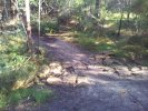
The trail is all through but needs more work to define the tread and add some more rockwork. So currently its still closed off, but will run from the creek crossing up the hill and traverse under the fields rather than through the mud at the bottom which sucked!