You are hereForums / By Discipline / Mountain (off road) / By Location / Australia / NSW / Newcastle & Hunter / Glenrock Trail Map
Glenrock Trail Map
NB: Originally posted elsewhere on the Global Riders Network and appears via syndication.
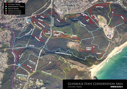
A little something I've been playing with in my spare(?!) time.
It prints nicely at A4.
The blue is maybe a little dark for prints which I'll sort out at some point.
Also have similar for the whole park but since the POM is signed off we're not meant to be riding these areas....
- Login to post comments
Tags


I think if I rode there I would still get lost, but great job
Very tidy job. Don't think it would last long on the noticeboard though.
That's the best map I've seen for ease of use and overall simplicity.
Thanks.
Hey Lenny can we get this up in a format that is printable for anyone to use?
Or is it printable as is? I didn't try.
Anyway whatever works can we have it put in the 'Maps' area permanently, please.
I printed it out at work today on A4 and it looks pretty good.
The only issue is that the blue used for the management trails is maybe a bit dark.
looks good to me
Just noticed the forum software is resizing the image plus the high res download from the map page need a little work.
If anyone has some suggestions on how this map could be improved then post it up....
Here's the full size map. Just remove the 'imagecache/Preview' part of the path
Someone will need to update the GTA Maps page to place '_0' on the end of the link there.
nice work. looks good
I hope the directional arrows help to get the message across.
Now if you could just do one for the moto's with no trail at all shown and one for wet weather riding that perhaps instead of trail names shows the cost of a new drivetrain and trail repair work.
Is that all our problems sorted?
Maybe one that shows all trails as 'Gnarly Descents' would cover it.
...I was hoping to improve it by adding in a big section of single track onto Shaft that cuts out the easement and loops around to the bottom of It Happens, several descending trails off GCR and another big loop into the southern half and back........
You forgot the loop descending from the tip following the contour down into murdering gully and continuing around until it pops onto the end of BJ's.
6 pack jumps direction looks to go wrong way on map
Well 5 and 1/2 really. This map shows the XC loops which follows the return trail next to the jumps.
If you want to do the jumps as well you ride up the roll-in hill smash out a set then come back on the return trail and keep going.
Nice work Browny, at least you're trying to convey some sense of it.
Points of interest such as the picnic table and the 'sitting tree ' would be handy (and the best way there and back).
Many of the arrows seem to be going the wrong way. (to the way I ride)
Easy way out (someone has a sense of humour) and Kennys are bi directional and I would have thought the upper and lower quarries would be also bi-directional as you would need to go back to the start of the jumps if you are doing repetitions.
I personally would not be putting the arrows in because of the danger of litigation. I'd leave it to NPWS.
They arrows are just what the NPWS are putting on the trail head map (its in another topic).
I don't really see Kenny's as Bi-Directional, just too much traffic heading in the clockwise direction during peak usage times. Kenny's isn't so much a sustainability issue like some of the others though.
That said, I do see trails like Seuss Land as being Bi-Directional.
The arrows are only recommended travel directions, they are consistent with the NPWS and I honestly don't see what the litigation issue might be.
Some icons to show trail features are a good idea. A jumps icon would be good (any suggestions?).
My understanding from this sight is that NPWS are reluctant to specify directions of travel.
I find the Shute deviation a better climb than decent, so I assumed Kenny's was a bi-directional trail even though I rarely travel that direction (I prefer down the shute aka Empy's Foley).
Easy Way Out has heavy usage both ways without problems.
I can recommend going down Double Barrel then over to Easy Way Out turn right at the end down the fire road through to the Fernleigh Maintenance Track to the upper creek crossing. Mostly rolling down hill and very nice. Left with a conundrum from then on, but still a nice start.
Whats the go with the 3 downhill trails opposite the entry/exit to six shooter. I heard they werent gunna be worked on any more because they were too dangerous or something?
might be best to ask NPWS they are the land manager
Say they will close them and rehabilitate the area - eventually.
We are pushing for replacement trails to be built first, that's pretty much what the NBN piece was about;
http://glenrocktrailalliance.com/node/34107
Anyway for the meantime make the most of what's there.
First off I'd like to say thanks for the map, it definitely helps me get around!
Just wondering if there was an updated version of it? I noticed that this was posted in 2010, so does this mean the map is also from 2010 or does it constantly get updated as more tracks are made/modified?
The map reflects the sanctioned trails in the Plan of Management. I think the only trail missing at this point is The Quarry Loop.
The site here always has an up to date map available here on the Glenrock page:
Glenrock State Conservation Area Map.
* It's as up to date as the data in people have input. Anyone can edit the trails here. It's like a Wiki.
Thanks for the info.
If the original map needs editing or there are other mapping ideas that people have then I'm happy to help out (it's about all I can do for GTA at the moment).
Whereas that original map was quite labour intensive, I've now got a program that makes it all a lot more automated with control over pretty much everything.
I started working with Empy on drawing up some suggested riding loops a while back but it seems we both got distracted so never finished it off.
Please just edit/remove/add specific trails in the Glenrock area to this site. The online map I linked to above will then just be updated automagically.
I'm just not into it though.