You are hereBlogs / Simon's blog / Manly Dam Trail Works Update: June '11 Description
Manly Dam Trail Works Update: June '11 Description
As discussed in the previous update on 27/6/11 the Manly Dam rangers arranged for a meeting at the dam to look at sheduled works on the Allambie side.
Overview
NoBMob and Manly Warringah club reps took a few hours off work to meet yesterday afternoon until well after dark to talk over the area commonly known as the 19th hole and a section near Cootamundra Drive. One of these reps was our own in house riding Geomorphologist (expert on soil erosion and design solutions).
The main points of discussion were:
- Making sure everyone is aware of the main lines that people take
- Ideas for track surfaces and controlling water runoff
- How to bring the track back to single track width
- Ensuring any reroute still provides room to access more advanced lines
19th Hole Discussion
Key issues at the 19th Hole are:
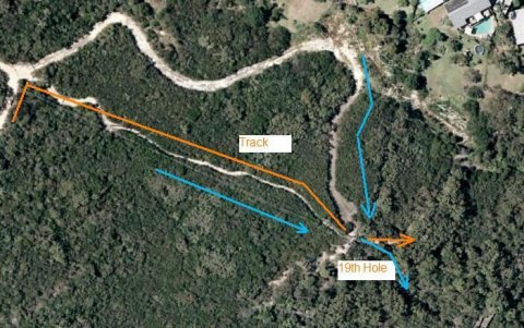
- Water channeling (blue) down the track and newish 4wd track punched in by the Electricity Board
- The track currently leads people straight to the old A-line drop (5-6 foot drop)
The alignment to the A-Line drop is perhaps less of an issue now as the vegetation has grown over the last 4 years, previously the sight line took you straight off it resulting in many people not familiar with the dam locking up at the end of the single track to avoid it. However the track is here to stay and vegetation is not the most permanent feature so this is still a good thing. The B-Line is also not a drop that requires any speed so changing the alignment should be no issue.
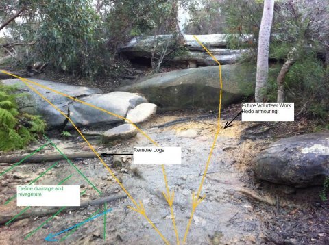
This water flows down the face of the old A-Line and B-Line, building up speed causing immediate erosion and also track widening and further erosion down the trail after the landing area. This area turns into a waterfall and stream after heavy rain.
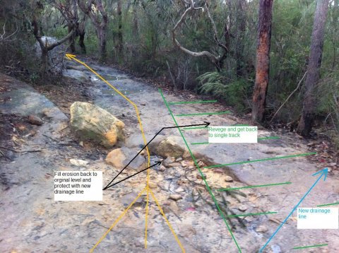
The area that has eroded beyond the landing area in the photo below used to be single track with vegetation either side.
19th Hole Remedy
It was agreed by all that the progressively widening single track above the 19th Hole is far from ideal from a trail planning perspective. It is basically fall line trail with very little outslope and so channels water. However we are left with a legacy trail that was:
- Initially power line access
- Became a walking track
- Then a mountain bike track
Discussion with rangers indicates that we would all like to look at better options or putting more time into drainage along this trail at a later date with better budget and/or volunteer work.
In the shorter term there will be a minor reroute for the last 10m or so before the 19th Hole. After discussion with rider reps, Rangers and the Contractor this will comprise of:
- Initial grade reversal on existing track prior to reroute to shed water before it gets to 19th Hole
- Subject to drainage details, possible berm to turn into new segment.
- More natural track on reroute than existing board walk and will comprise of a buried armoured surface
- Rocks along track sides to assist holding armour in place. There is very limited topsoil in this segment and it needs to be protected.
The grade reversal to control water and the minor reroute will start approximately as indicated below (about 10m before 19th Hole) and rejoin the track as indicated. This will assist with water runoff and also stop leading newbies to the old A-Line drop.
We have emphasized that where this rejoins the existing C-Line provision needs to be made in the alignment so that the more advanced lines can be easily accessed otherwise the new segment will widen at the end after construction as people take the different options.
The water run off from the newish Electricity Board 4WD track is a big issue. Rangers are looking at how this can be addressed either by Council or Electricity Board. Unfortunately the Electricity Board has some powerful access rights. Drainage on this new track will need to be resolved before issues in the landing area can be fully resolved.
In the landing area it was agreed by all the need to preserve the B-Line and C-Lines and to also bring the track back to single track width. The old A-Line was always problematic with the immediate landing never retaining soil and also the alignment of the runout down the track. It was also generally better suited for bigger bikes than ridden around the dam.
The best solution identified when considering drainage was as follows.
Cootamundra Drive Discussion
At Cootamundra Drive key issues are:
- Boggy ground conditions with minimal outslope for drainage
- Tread creep / Trail widening
This area is shown below.
It was getting a little late for photos in this region. The bog is difficult to address, based on levels and the vegetation any reroute in the immediate area would still have similar issues.
For the areas with tread creep and gradual widening we looked at trail flow, considered the slightly off camber rock shelf, vegetation and the rocky climbing segment at the exit of this section.
Cootamundra Drive Remedy
This area will require further discussion to find a permanent solution. In the shorter term this will involve:
- Rocks to reduce trail widening, location to be marked in yellow by rider reps
- Patch to address boggy area
Timing and Contacts
These works are weather dependent and will start very soon. During this time please observe any trail re-routes, hopefully the remainder of the trail can remain open for much of this work.
There are many other areas of the dam riders would like to see fixed up. We have been discussing with staff how we can arrange for a process by which riders can put forward trail maintenance suggestions and also be involved through volunteer work.
Again the Mayor should be our last port of call not the first. We have re-established communication with the ranger and management of the dam and they are listening (thanks to you all for the letters over recent times). Lets keep the momentum positive and forward.
- Simon's blog
- Login to post comments


When i read about the rerouting of the 19th hole section i was thinking we would lose that small bit of single trail with the llittle log drops etc. Thankfully that wont be happening Although a very simple section of the trail, its one part i do like of the trail and would be sadened to see go.
As for the widening bit.... do you have pics of how it looked before? For the last few years i cannot recall that section being much narrower and wouldnt have expected that it could get any wider than it is now due to the rocks to the left and the drop to the right.
I am sure i will be corrected but wouldnt there be areas of the Dam that could be attended to before the 19th hole? I feel there aree areas of the trail that would benefit from work more than this section.....
Drainage just past the school, drainage along the rock garden area, drainage not long after heart break hill....
The lines of communication with Council rangers are now working well again so feedback on the good points and areas where we all think work is required is good to get. Any suggestions relating to these works posted here will be discussed and put forward. Minor details may wait for volunteer days.
The current works are part of the overall scope given to the contractor that included the recent works on the Wakehurst side. All these works are part of the 2010/11 financial year budget and same contract with the contractor. Priority and scope was based on a consulting report. The report in itself was not bad overall but, in my opinion, the priorities are out of date as many other areas have emerged since it was written, especially given how wet the last 18 months have been compared with other recent years.
I agree, it is evident that there are plenty of other areas that need maintenance. Frequency of audits and timeframe for implementation has been a topic of discussion with rangers and council. I have another 75MB of photos and video, many in the areas you mention, taken on a walk in the rain recently. We have gone over these with council and rangers which has assisted with some of the details above for the 19th Hole. Hoping to address the other areas that you mention in the new financial year through a contractor or volunteer days. Either way if we keep building the current renewed relationship there will be much more rider input going forward than in the last 3 years to both the decisions and the contractors work.
As you say this section is unlikely to get any wider and has been stable in the last 2-3 years at least. Reclaiming single track width at the Dam has to be a good thing as is solving the erosion problem and replacing the lost soil.
My memories in 2005-2006 are that it was narrower and didn't extend out to the tree's on the right as far. I am happy to be corrected. However the current recommendation after meeting on site this week makes sense for drainage and merging the B and C lines back into single track. They also date back to the last rider prepared trail report from early 2008 (before my involvement in advocacy work with Council) which was prepared but never implemented as the volunteer days ceased. The alignment change at the top while in the consultants report was also in the same rider prepared report.
The last rider prepared report, as with the consultants, also does not include the current areas that definitely need attention. A lot has changed since then.
A few of us are planning on doing a full trail audit to assist in providing more up to date priorities. This would then be posted for comment and it would be great to get more people involved. We are talking with council about how to formalise a process for providing more frequent trail maintenance suggestions/audits and assisting with volunteer days.
Rob, Hawkeye, myself and others will be getting something up on NoBMoB about this in the next few weeks and have been coordinating and discussing ideas with local clubs and industry.