You are hereForums / By Discipline / Mountain (off road) / By Location / Australia / NSW / Northern Beaches / Northern Beaches Trail Advocacy / Get on your bike in NSW National Parks!
Get on your bike in NSW National Parks!

NSW Office of Environment and Heritage /NPWS have added some important new information to their website late last week.
to access click on the What's new link at http://www.environment.nsw.gov.au/
Cycling Policy: http://www.environment.nsw.gov.au/policies/Cycli...
Cycling - what’s possible in more than 50 National Parks: http://www.environment.nsw.gov.au/NationalParks/...
Sustainable Mountain Bike Strategy document: http://www.environment.nsw.gov.au/parkmanagement...
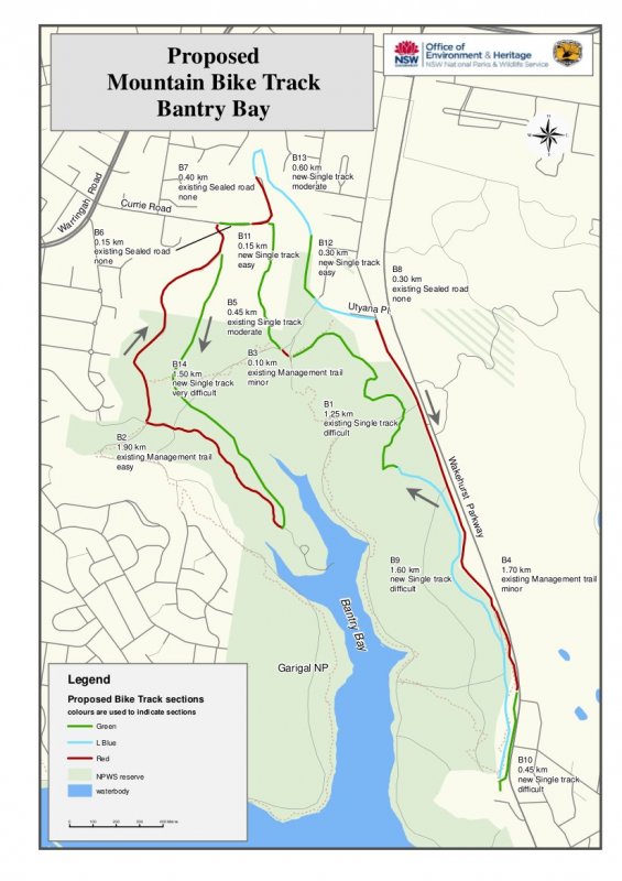
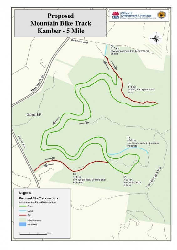
Northern Sydney MTB Pilot Program with Maps of proposed trails for Garigal and Berowra Valley: http://www.environment.nsw.gov.au/parkmanagement...
Northern Sydney Mountain Bike Program
Cycling is a healthy way for visitors to enjoy the natural heritage of our parks and appreciate the importance of their conservation.
Mountain biking is a rapidly growing recreational activity in NSW and there is high demand for this legitimate recreational activity in our parks and reserves. At the same time illegal mountain biking on walking tracks has caused a problem in some of our parks.
The new National Parks and Wildlife Service (NPWS) Sustainable Mountain Biking Strategy is the first time we have a clear way forward to make sure mountain biking in national parks is safe, fun and sustainable.
What's proposed for mountain bikers in northern Sydney?
High quality mountain bike experiences, including some sections of single track will be provided in suitable parks over the next five to 10 years.
One of the priority projects we have identified is the provision of a sustainable mountain bike track in a northern Sydney national park.
The NPWS has identified three possible sites for a mountain bike track of at least 10km in length in northern Sydney, from which one could proceed through to construction.
A preliminary assessment of these three locations has occurred but further work is required before the construction of a track can take place.
Throughout this process, community consultation will occur in a number of ways. If a preferred track is identified in the process, an environmental assessment will need to be undertaken which will be placed on public exhibition.
Before any construction can occur, the plan of management for the reserve will need to be amended. A formal exhibition period is required for plan of management amendments. Two of the assessed sites are in Garigal National Park and one is in Berowra Valley Regional Park.
An advisory group will be formed to guide the consultation and represent the interests of the community.
In the meantime we are inviting you to have a look at the assessed sites. NPWS rangers and planners will be on hand to explain the thinking that has gone into selecting these sites, the environmental assessment process that needs to occur and how you can be involved. We are interested in what you think of the three options. Our knowledgeable staff will be available to point out some of the important natural and cultural values of the sites.
You are invited to attend one or both of the following information days.
Location: Garigal National Park
Date: 29 October 2011
Meet at: Seaforth Oval, off Wakehurst Parkway, North Balgowlah
Time: 11:00am to 2:00pm
Location: Berowra Valley Regional Park
Date: 5 November 2011
Meet at: Stringybark Ridge, off Schofield Parade, Pennant Hills
Time: 11:00am to 2:00pm
Drop in any time from 11 to 2 to talk with the rangers; you can get directions to view the sites. Please note that there are no formed tracks at this stage.
Download maps of the proposed mountain bike tracks for:
http://www.environment.nsw.gov.au/resources/park...
http://www.environment.nsw.gov.au/resources/park...
http://www.environment.nsw.gov.au/resources/park...
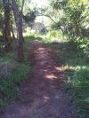
[Mod. embedded maps]

- Login to post comments
This is even better than I imagined. The new single track is literally in my backyard.
The bantry bay / manly dam loop looks like a great ride of about 20k's.... And the new official trails at Oxford Falls!!! Love it.
To the guys who have been working so hard with NPWS and the other official bodies Thankyou, Thankyou, Thankyou!!!
If there is information on volunteer days formtrail building I'd be very interested.
This is great news however these are proposls only at this stage, I think NPWS have some more assessment work to be completed before these will get the final ok. No doubt will generate a lot of interest and comment including some from the anti-mtb lobby. Please provide positive feedback to the OEH/NPWS. A great way to do this would be to attend the planned information days
Location: Garigal National Park
Date: 29 October 2011
Meet at: Seaforth Oval, off Wakehurst Parkway, North Balgowlah
Time: 11:00am to 2:00pm
Location: Berowra Valley Regional Park
Date: 5 November 2011
Meet at: Stringybark Ridge, off Schofield Parade, Pennant Hills
Time: 11:00am to 2:00pm
Drop in any time from 11 to 2 to talk with the rangers; you can get directions to view the sites
very helpfull!
will be at seaforth oval meeting!
Thought this was confirmed.... Hey at least therevwill be no issues with the neighbors if NPWS choose the Bantry Bay option...
I've put 2 meetings in the calendar for these events:
Garigal: http://nobmob.com/node/31601
Berowra: http://nobmob.com/node/31602
Please turn up and show your support and thanks
It's been mentioned elsewhere that with the Bantry Bay track NPWS/council would likely try to get riders to use a crossing further South than is currently the norm.
To be honest, this sounds good to me, so long as the trail links there. However, a dream would be a foot/cycle bridge across the parkway. I can already see the wooden boards on steel structure with dual ramps up from both sides. Would make a nice trail feature, non?
crossing further south would mean either missing the single track above the golf course or riding south on the road for some distance to get to councils preferred crossing point. Surely there is a better / safer option than that?
From Hydro Lab you'd ride up to the golf course and through the oval as normal.... you'd just take a 10K detour on some sweet new single track and fire road sections before crossing back over to do the trig track....
Or another option would be to start at the Sea forth Oval car park, start the ride by crossing over, doing the Manly Dam circuit then crossing back to do Bantry Bay.
Sure you could skip the single trail at Manly Dam but there's no need from what I can see
Although I have no real interest in riding the proposed trails, it seems great for some members of the MTB community.
I'm just hoping it doesn't feed an argument to more decisively close down the trails I actually like to ride...
@bikesarefun I'm curious as to why you would write off these draft plans before seeing the final result? Do you imagine the proposed trails are too far for you to travel? Or not enough technical terrain? Or too much? Or not enough descending? Or climbing? Or simply too short?
I think we should all see this as a pretty positive move and note that there will probably be plenty more consultation. Maybe you can show up to an information day or otherwise get involved in the planning and try to get something you'd enjoy?
That said, your comment is a bit ominous... where are your favourite trails right now?
It is because they are only catering for XC riders when 95% of trails that get put in NP are Gravity orientated.
NP's hold most of the land with the highest elevation which is needed for Gravity trails
A benifit of formal mtb trails is removing the need for informal trails, cateting for XC only will not remove the need for gravity trails on an informal basis.
I here Thredbo (National Park) has pegged out DH(Gravity) trail number 2
So its been a while since this threat was started and commented on... Does anyone know if these "PROPOSED" tracks are still draft, or are they ACTUAL tracks we can ride now?
Trail proposals have moved past the draft stage in many cases, and are well into the environmental assessment or later due diligence stages. There is a huge amount of work that needs to be done before trails go in to ensure they aren't at risk of closure when political winds change in the future (as they inevitably will).
I'd encourage you to sacrifice a few coffees this week and spend the savings to join Trail Care. You'll get up to date information on advocacy efforts, be able to more effectively contribute and add to the strength of numbers pushing for trail access and volunteer trail maintenance participation.
www.trailcare.com.au
No tracks to ride as yet. The approval process is a joke! We had tracks closed down years ago and still nothing has happened.
I know people will jump on my comments and say I should be patient but this is how alot of people feel.
The approval process needs to be streamlined and made alot easier!
Hi all
I met with the key NP's director 10 days ago to get an update and provide feedback.
The approval process is frustrating but it's the same for anything now, especially when it is politically sensitive. Now we are beyond the politics things are progressing at typical speeds for government.
My impression though is that they may be open to credible proposals to reopen or formalise some existing tracks. TrailCare has begun this process especially where it is easy to demonstrate erosion is due to water and will continue to get worse even though trails are closed. Easy to argue that the best and cheapest outcome is to let riders fix it up and ride it. Or where the unofficial trail is so well built and maintained it is arguably better than many official walking tracks and firetrails. If you want to coordinate efforts please let me know and PM your phone number.
At senior level there was some interest in how short single track segments could be made to link with firetrails to create a series of stacked loops or even an off road route from the beaches to Hornsby. Again PM me if you want to put forward ideas.
Cost effective solutions are topical given budget cuts in the public sector.
Edit: I see Simon has beaten me to it
Hi all
I had a phone discussion last week with National Parks.
We will be meeting up soon to discuss next steps for a number of ideas around Northern Sydney.
Will update everyone after.
As you maybe aware National Parks has had budget and staff cuts which is making things complicated for them. The fact that they are still calling me and progressing things demonstrates how serious they are about all this.
Appreciate the update, will be good to keep the momentum going whilst we wait for some funding for new trails