You are hereForums / By Discipline / Mountain (off road) / By Location / Australia / NSW / Northern Beaches / Trails shown on Google maps, how to get changed.
Trails shown on Google maps, how to get changed.
Is it possible to update the trail maps shown on Google maps & Google earth on NobMob?
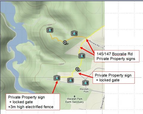
Yesterday went for a ride at Terrey hills, & found that the trail marked to the South of the intersection of Cullamine Rd & Booralie Rd has no legal entry or exits.
145 & 147 Booralie Rd have placed private property signs at the Booralie Rd entrance, plus private property signs & gates exist at all the exits further South. The trail terminates at a 3m high electrified fence surrounding Waratah Park.
As it is no longer accessible, is it possible to remove the trail on Google maps & Google earth?
[Mod. moved to Northern Beaches]
- Login to post comments


The trails are still there, are they not? If the signs are new then my view is they should stay in the database and not be removed pending further investigation.
Firstly, this tracks all of the available trails regardless of whether they are legal, accessible, authorised or otherwise, which is an important function.
Secondly, you are assuming the private property signs are valid. It may be that they are valid, but there has been more than one case reported recently where landowners have tried to misappropriate rights of way and deny access to others. I reckon their validity should be independantly verified before being taken down
The trails DB is wiki like and anyone can edit.
Go ahead and update the trails, or at least place a comment on the particular trail pointing out the error. Think this is the one you're saying there is a problem with:
http://nobmob.com/node/7461
BTW - we spoke about this years ago and someone pointed out that the developers would probably have to put in a fire break between the NPWS boundary and these properties. Perhaps a well timed inquiry to NPWS about how one can travel north/south against this boundary would be nice?
Been doing a lot of calling today to see what the status of this track is.
1) Warringah Council: Contacted about private property sign & fencing at 145 Booralie. Said would have a ranger take a look in the next few days,
2) NPWS: Confirmed that part of the trail ran through private or crown land, though believed it was a designated fire trail. Park ranger to take a look at locked gate & private property sign at Joalah Rd exit, as not allowed to block a fire trail.
3) RFS (Rural Fire Service): Although a designated fire trail, access is only for emergency or maintenance by RFS personnel. Access regarding the public to fire trails is not within the RFS charter.
4) Dept of Primary Industry, crown lands (replaces Lands dept/LPMA): TBA
Great work and thanks for following up.
Will be very interested to hear results. Would be good to get names, and confirmation in writing if possible so it can be posted here.
This helped recently in confirming the status of Cowan Track as being open to mountain bikes after walkers vandalised and then removed the "mtb allowed" signs at the entrance. Access was disputed and could have been lost without copy of that document being able to be furnished as proof.
From: Anthony Ryan [mailto:[email protected]]
Sent: Friday, 16 December 2011 2:10 PM
Subject: Response re enquiry status of lands - Booralie Trail, Duffys Forest NSW (11/04567)
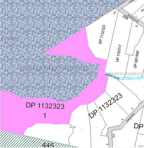
Please see diagram attached. (see pics 2 & 3 in initial posting)
In the map image: NPWS land is shown by blue/green pattern; pink is Council land; Crown land shown by green striping; and the non coloured land are private freehold.
From the aerial image: it would appear that (from the north) the trail traverses private land, thence onto Council land and back again to private land in the south.
As such I believe any access across these lands would be a matter for the landowners.
Regards
Anthony Ryan | Group Leader Natural Resources and Property Services | Catchments and Lands
Department of Primary Industries | Level 12, 10 Valentine Avenue | PO Box 3935 | Parramatta NSW 2124
T: 02 8836 5304 | F: 02 8836 5365 | E: [email protected]
W: www.crownland.nsw.gov.au | www.dpi.nsw.gov.au
Hi Bob,
Many thanks on an outstanding job chasing this stuff down and sharing your work. Very much appreciated.
I have speculated before that it is the duty of someone (private landowner or NPWS?) to provide fire trail access between private property and NPWS land. If this is the case it's a win for users of these trails because looks like the new land owners have to provide actually more trail than they remove by building over the existing one. Ie. they close the direct North/South link and have to replace it with a trail that runs West and then back again which would be a longer distance, which is probably nicer.
Does anyone know if this is actually a requirement though? I mean, is it really possible that this North/South link be removed without being replaced by any other trails? Are these landowners seriously contemplating living here without any buffer between their property and the NPWS land?
NPWS has existing agreement with RFS & landholder to access trail for fire control purposes. New access trail bypassing 147 Booralie Rd, through virgin bush highly unlikely to be approved.
Bottom line, for all practical purposes the trail is closed.
1) Warringah Council: Confirmed North & South exits now in private land. Council has no plans to build an alternate access road as would involve funding for repurchase of land. Also highly unlikely to get approval to create new trail involving removal of trees.
2) NPWS: Confirmed that part of the trail ran through private land. NPWS has existing agreement with RFS to access trail for fire control purposes. New access trail bypassing 147 Booralie Rd, through virgin bush highly unlikely to be approved.
3) RFS (Rural Fire Service): Although a designated fire trail, access is only for emergency or maintenance by RFS personnel. Access regarding the public to fire trails is not within the RFS charter.
4) Dept of Primary Industry, crown lands (replaces Lands dept/LPMA): Confirmed North & South exits now in private land.
Options:
1) Negotiate with owner of 145/147 for access to the trail by MTB.
2) Lobby NPWS & Warringah council to build a new trail. Note. Warringah council officer believed this was unlikely to be successful given the environmental concerns.
In the meantime, can this trail be removed from Google maps/google earth?
Yeah - we will add a 'inactive' or 'closed' status or something and mark this trail as such, and make sure those with this flag don't appear on the maps.
Thanks for all your efforts.