You are hereMitchells Way - Gum Ridge loop
Mitchells Way - Gum Ridge loop
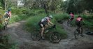
From the bottom of Mitchell's Way we climbed up to Gum Ridge then back through the pines.
Sunday 13th May 2012 - it was cold and ended up being wet but we had a good MTB ride.
This google map is just hand drawn using the aerial photos on google earth so is just an estimate. The single track is very approximate, and the Gum Ridge Trail (through the native stuff near Mt Towac) is hard to follow on the aerial photos.
We started at the bottom of Mitchell's Way (near Cargo Rd) and headed up the hill to the bitumen. Then right and right again passing Federal Falls picnic area. Then right just before Mt Towac, up a challenging climb then followed the fun trail down Gum Ridge. When we got back into the pines it was a matter of keeping right to get back to Mitchell's way.
- Login to post comments