You are hereForums / By Discipline / Mountain (off road) / By Location / Australia / NSW / Northern Beaches / Northern Beaches Trail Advocacy / Draft Forestville Park Plan of Management – Public Exhibition
Draft Forestville Park Plan of Management – Public Exhibition
For those not on the distribution list, got this in the mail today...
2 April 2013
To whom it may concern
Draft Forestville Park Plan of Management – Public Exhibition
As you may recall, during April, May and June 2012, Council undertook community consultation and exhibited the draft Forestville Park Plan of Management.
Forestville Park has high heritage and biodiversity values and contains significant environmental features such as watercourses, rock outcrops, various types of vegetation and fauna habitat. The management intent and actions proposed within the draft Plan of Management focus on enhancing and protecting these values, and include continued management of environmental pests (including weeds, foxes and rabbits), management of recreational access, maintenance of facilities, and bushfire management.
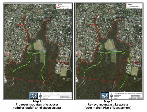
Since the close of the first exhibition period it has become apparent that managing impacts on significant heritage associated with mountain bike riding in the locations proposed is not possible, therefore alternate mountain bike access has been identified. The original proposed access and the new access can be seen on Maps 1 and 2 below. The revised mountain bike routes identified have been developed in partnership with staff from the adjoining Garigal National Park to ensure consistency in management approaches. The remainder of the draft Plan of Management remains the same as that exhibited previously.
Council wishes to invite you to attend an information session on the updated draft Plan. The two available information sessions will be held on Thursday 11 April 2013,
6:00 – 7:30pm, and 7:30-9:00pm at the Council Chambers, Civic Centre, Dee Why.To reserve your space please contact Council’s Customer Service Centre on 9942 2111.
The draft Plan of Management will be on public exhibition from 2 April - 13 May 2013 and can be viewed at the following locations:
- www.warringah.nsw.gov.au
- Civic Centre, Civic Drive, Dee Why
- Council libraries at Dee Why, Forestville, Belrose and Warringah Mall
Comments can be in writing, addressed to the General Manager, marked ‘Submission – draft Forestville Park Plan of Management’ or emailed to [email protected].
To register your interest in attending the information session or for any other enquiries relating to the draft Plan, please contact me on 9942 2111.
Thank you for your participation in this process
Kind regards
Vivien Howard
Senior Environment Officer – Biodiversity
- Login to post comments


That's a pretty extreme section of trail. I like techy descents and fancy myself as being OK on a bike and have to say that's virtually unrideable for al but the very advanced rider. The bottom of the trail is also very eroded.
Is the thought to reroute the current trail or just keep as is?
I also assume the this is just the descent and that the original return leg won't go via this route?
On a positive note it's great to keep this moving along and if it means having to tackle this descent (and walk it until I can) then it's well worth it.
Just want to get your assistance with fact checking before I send this off. Been awhile since I've ridden these trails and the memory is foggy: have I missed anything?