
You are here
nobmob.com

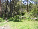
Unknown Neverfail

There's a bit of what looks like single track leading left/North from here (main trail is running North East). It's not marked on any map so didn't take a look, perhaps it leads to Coonawarra Road or just to private property.
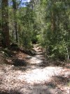
Neverfail Junction

Around halfway along Neverfail Gully Trail. The main trail goes downhill to the right/East, think the other leads a few hundred metres to Coonawarra Road, but didn't check that.
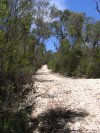
Neverfail Gully North
This is very close to the East end of Sandy Trail, on Cooyong Road, Terrey Hills.

Wednesday morning ride
anyone interested in a ride on Wednesday morning before work... 7am start @ Oxford Falls?!?!?? ( Morgan Rd.)
Bernd
100m Walk
Looking back to the creek crossing. This trail is marked as a walking track, but the 100m or so around this point is about all there is that isn't really fire trail.

Water Bar Madness
This trail is marked as a walking trail on the topo map, but clearly is not. It's way steep fire trail with lots of water bar madness to be had on the way down. Take care!
Silly Steep Leg

That right turn lead down here. There should be a medal for those able to ride back up this steep and slippery stuff.
West End of Ryland

Sadly there's no view or other reward to greet riders at the end of Ryland. Ah... although is this the end? The topo map shows another 500m or so more, and a very overgrown path leads down close to one of the pylon legs.
Steep Stuff

Main trail heads left here, another kilometre or so to the end. For the curious have a look right, but it's short, steep, loose and not very rewarding.