
You are here
bmorc.com

End of the Hurley Heights Fire Trail
NB: Originally posted elsewhere on the Global Riders Network and appears via syndication.
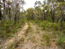
At the end of the Hurley Heights Fire Trail it just becomes this very overgrown double track.
Here you are very far from civilisation so its not that tempting to go exploring further. Further there are no views.

Rock Wall Vertical Panoramic
NB: Originally posted elsewhere on the Global Riders Network and appears via syndication.
Mount Hay from Hurley Heights Firetrail
NB: Originally posted elsewhere on the Global Riders Network and appears via syndication.
Butterbox Point and Mount Hay Panoramic
NB: Originally posted elsewhere on the Global Riders Network and appears via syndication.
Butterbox Canyon Panoramic
NB: Originally posted elsewhere on the Global Riders Network and appears via syndication.
Map from Trail head Signage
NB: Originally posted elsewhere on the Global Riders Network and appears via syndication.
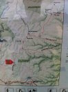
At the trail head there is signage with plenty of information, this is part of the map.
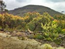
The Pinnacles, Rock wall, Mount Banks and Mount Hay from Flat Top
NB: Originally posted elsewhere on the Global Riders Network and appears via syndication.

After our short climb up to Flat Top we had an amazing view of The Pinnacles (3 hills), Rock wall, Mount Banks(background far left) and Mount Hay(background far right)
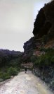
Rock Wall (does it have a special name?)
NB: Originally posted elsewhere on the Global Riders Network and appears via syndication.
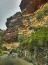
Just an amazing feature
(Erosion must have been caused by Down Hill bikes because they are heavy) 
Rock Wall (does it have a special name?)
NB: Originally posted elsewhere on the Global Riders Network and appears via syndication.
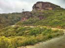
An amazing rock feature next to the Road
Mount Hay
NB: Originally posted elsewhere on the Global Riders Network and appears via syndication.
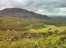
As beautiful as a mass of earth and life can get