You are hereBlogs / kiwiboy's blog / The Blue Mountains Epic - or There and Back Again
The Blue Mountains Epic - or There and Back Again

Well, thought I might share an experience from the weekend with you all.
Due to other commitments we (Mark & Tracy) were unable to participate in most of the planned rides (Mini DW etc) over the next couple of weeks in the lead up to Bateman's Bay, so we decided to go and revisit Anderson's and The Oaks. A group of us did this some time ago (when we busted the Scott for those who may have seen the trail repair picture) which didn't go exactly as planned. Nevertheless we had a good ride and the distance (around 60-65km) was about what we wanted to do. So this time ended up with me and my significant other and Leo, who had come with us last time. Bit of a ride, finish mid afternoon, home for the rugby - sweet.
We got ourselves to Glenbrook by 9am Saturday and met with Leo. First impediment - managed to leave the Edge GPS behind (no HR monitor doh!!) - never mind, ridden it before (once), would have been good to compare, but we can manage. (Queue Twilight Zone music)
In due course we trained our way up to Wentworth falls and off we went like good little troopers, about 10.15 am as we rode past the clocktower. Last time we had maps from some website and printouts from Fat Hippy, but somehow the maps had not made the pack this time although Leo had Fat Hippy's directions, but again we had already done the track so felt confident (damned music, go away!!)
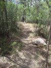
We barrelled our way down the trail, Leo on his bright and shiny new steed (nearly top of the line Giant Anthem out for it's inaugural ride mmmm oooo aaaaa very nice) and a good time was being had by all. Both our Rush's freshly serviced and tweaked at the LBS all is well and good in the world - I mean what's not to like about a nice track deep in the forest? The firetrail has a few forks and sidetrails, but we confidently picked the line most used and recognised familiar landmarks from our previous expedition. We came to the turnoff (about 20km in) with McMahons Point Lookout sign pointing downhill and confidently turned uphill (is that music I hear??? Twilight Zone, are you there??)and about 200m in we came to a freshly painted locked gate, with a bright shiny new sign on it. Hmm we thought, do remember passing a gate and hike-a-biking over it - but the sign doesn't ring a bell. Rationalised it as a new sign, remember to post warning to NobMobbers about possible trail closure. Besides, don't want to ride back. (ah the music!! it is inside my head!!!!) Into gear and awaaay..... sweet track, generally, although the surface very loose and a bit dodgy on some downhill bits. Another 5 or 10 km in we come across another gate. By now we are thinking hmm, should have passed the stream by now, don't remember this bit, where are the rocky bits where we broke the Scott, and so forth. This gate we have never seen before. O dear. A careful review of our meagre directions reveals nada. After a bit of a discussion and a review of options, we figure hey, can't be that far from Woodford, I mean its only 35km right? So we press on. Sweet long downhill with stream at the bottom (the stream!! the stream!!) and around the corner should be the uphill - and indeed there is but it is one we have never seen and it is a killer. So, here we are, at the top of a nasty climb, 40kms in, with 1 bar reception on the phone. O dear again. What to do? Google maps on the phone doesn't help, no roads here, and besides, we don't know where here is!! Argh, the GPS, where are you?! Who to ring?? So here is the rub - who would you ring if lost in the Blue Mountains firetrails?? Not emergency services, for sure - can just see us on the news tonight, o no not likely. Well, Telstra 1234 of course!!! LOL poor guy had no idea who to call but eventually gave us a list of numbers and we rang the SES - no help, cos the duty officer was at home anyway. Somehow I had this picture of some fire rescue type waiting in his control room with a nice big topo map who could tell us "Ah yes, I know exactly where you have described, go 10km and turn left and there you are". Took many short calls dropping out before we realised our fate. I mean, I can't call this guy into the office from home on a Saturday bcos we are stupid. Not fair. So, only thing for it, ride back the way we came. Ahhh, that music. The fatalistic slump of the shoulders as we remembered it was a generally gradual downhill from Wentworth Falls for most of the track, which means a gradual uphill back, and first up was a gnarly loose surface uphill grind. Fark!!! So off we go. By now its like 1.45 pm - a calculation tells us we might just make it before dark. Before long a message on my phone - the nice SES man ringing to say he has passed our details to the Police Emergency Rescue!!! Argh!! My phone rings about 3 or 4 times (a screeching stop each time and a frantic scrabble thru the rear pocket) but reception is not good enough to hear anybody.
Eventually (about 55km) we came to a spot where I could call, and the nice policeman wanted to know who we all were and our dates of birth (so they can identify the bodies?!? the music is loud!) and our phone numbers, battery levels and how well we are equipped etc. Still with visions of being a headline act on tonight's news and with a promise to call the constable as soon as we hit the tarmac, we get under way as quickly as we can. After 3pm with around 25 km to go. Ah, the first gate and before long the second. By now we are 60km in and it hurts. I mean, it really hurts. We are all low on water, although luckily we had all brought a lot of food. So, Tracy and I briefly reminisce about the Dirtworks (we know we can do it, right??) and the Coffs Marathon (erm, well, not quite so good, 100 turned to 50 for me and Tracy swept at 70) and other past rides and events. Leo is hurting, we all are, we hadn't planned for this. We grind it out, granny gears getting a thrashing as our legs suffer and many hills flatten out to a slow incline. About this time, just as we were congratulating ourselves on no gear failures, somehow my front derailleur gets itself bent right out of shape. Bugger me, what next. Trail repairs, I somehow bend the sucker more or less into shape and we hit the trail, my chain making the ugliest noises on the shifter. At least it drowns out the music. Light is fading, its getting on for 4.30, by our count it is now only 10km to go. it's getting pretty cold and the despite the sweat we are all feeling the chill.
Never have I been so glad to see a bit of tarmac on my mountain bike as I was on Saturday at dusk as we swept past the hospital there. Of course, still 6km of road back to the station, and some of it on a bit of a gradient, but hey, we are ALIVE and out of the bush and, most important, not the main event on tonight's breaking news. I call the nice copper and tell him to call off the choppers, (fade the music!!)and we zoom off in the fading light and traffic. As we pass through Wentworth Falls our stomachs are rumbling, but we look like apparitions - grimy, dusty and sweaty, we couldn't go drop down in a food place, besides, we stink and we want to get home. Leo sips his last water as we hike our bikes painfully and stiffly up and down the stairs to get to the station, to find the gods finally smiling on us - there is a train in 10 minutes - they only come hourly, we could have had a big wait. We have about a cup of water and half a soggy gel left between us, but we didn't care, we boarded the train and slumped in the seats in the warm train... absolute bliss. For the next 45 minutes on the train we doze and dream of steaks and hot food and drink, before staggering off at Glenbrook, mumbling our goodbyes and heading for home.
By our count elapsed time 6 hours 45, ride time about 5 hours 15, distance 80km and total altitude gained 1480m (thanks to Leo's fancy trip computer).
Note to self - take a native guide on the second trip as well as the first, or, stupid, TAKE A MAP!!!
---------------------------------------------------------------
experience is something you usually get right after you need it
- kiwiboy's blog
- Login to post comments
Wow... great read, thanks for sharing. This might have made it into one of my 'Embarrassing moments in MTB' series... only to not panic, retrace your steps and survive isn't that embarrassing, eh?
Looking at the map I... erm... have no idea where you must have been! Either you took a turn way too early and rode Ingar Fire Trail (but that doesn't make sense - you would have been at the stream far earlier) or you turned a little too late and rode Red Ridge Road and it's not a dead end top of a hill that the map says it is (quiet unlikely!).
No, maybe you just went waaay too far before that left - there's a whole maze of trail marked down there, geeze, turning round and retracing from that was a smart choice indeed!
P.S. It doesn't really matter where you put this stuff, but create a blog entry is also a good choice. I can switch it in there if you like, no drama as is though.
I can certainly sympathise. I've been uncertain of where I am in the bush too many times, and as much of a pain as it is, I've learned that as soon as I become unsure of where I am, it's best to go back to the last spot where I knew where I was. It saves many tears later. Lucky you did know the way back, or you really would have been lost and in trouble. You also had heaps of things in your favour (phone, water, computer so you can guage distance, fitness, other people with you etc) and this, thankfully, is just one more experience towards being a safer rider. That rising panic of being in the wilderness with no idea of where you are is one of the worst feelings there is.
Turns out we were on the access roads to the power pylons - I haven't located it on the map yet, but there were regular cross roads with numbers that I figured out were pylon numbers. We actually rode under them for a while. They confused us a little because we thought we remembered them, then afterwards I figured out we were thinking of GNR/commission track :-/
we got as far as pylon 197 - I will find it on a map one sooner or later.
----------------------------------------------
if at first you don't succeed, try not to look astonished.
What a night mare!! am sure you lost half your energy worrying ('listening to the music in your head').
Well after this the Angry Dr. ride will be a piece of cake for you
Horrible!
Maaaate!!
Good on you for Retracing your path - and for ringing someone.
It would have been problematic, to say the least, had one of your party injured himself in a location with no reception, and you hadn't already made those phone calls.
I know the area reasonably well, and although I don't have a map in front of me, I think I pretty much know exactly where you went. You would have been heading towards the Warragamba catchment area. This means
a. Dead end trails
b. Steep terrain
c. Very few walkers/ MTbers - pretty much just the SCA patrols.
Had you continued on, you would have either ended up at the bottom of a (large) hill at a dead end, or, if you were lucky, gotten on a bit of a gruelling dirt road... first stop Warragamba.
Areas like this are quite psychologically intense. There are so many little turn offs and side roads that you lose track of whether you are on the main route or on a small diversion.
And all the dead ends are particularly unnerving. In cities, all roads lead someone safe and populated. Thus, many people, when lost (usually in cars) just keep on driving till they get to some place they know. The fact that this obviously doesn't work in remote ares, particularly protected (catchment) areas, can be scary!
As for ringing people - yeah the SES is made up of (mainly) volunteers - so it operates on an on-call basis. So, if you had become really lost, the choppers, 4wds, dogs, and SES would have rocked up with the Police.
The police are the ones who co-ordinate search and rescue. They liaise with the people who make the report, getting descriptions, etc.
But yeah, good on you for making the right choice. It can become so tempting to just continue downhill in those situations irrespective of the consequences.
(Oh and I just thought that I'd add, that although I've created the 'you only just escaped with your life picture' it probably wouldn't have been that bad if you hadn't retraced your path-just really inconvenient and uncomfortable- simply because of the powerlines. If you managed to let anyone know that you were near big powerlines near Wentworth Falls, people would have been able to find you really quickly- They'd just drive a 4WD down the maintenance tracks. That is, of course, provided you had some warm clothing. The fact that it's winter means that they probably wouldn't have waited till the next morning to look for you.)