You are hereForums / By Discipline / Mountain (off road) / By Location / Australia / NSW / NSW Trail Advocacy / Bantry Bay - stop riders pissing off NPWS
Bantry Bay - stop riders pissing off NPWS

If anyone knows who is riding Bantry Bay at the moment, particularly the Wakehurst Parkway side please get them to stop.
NPWS are seriously unhappy. Not all structures are in and people are riding on sensitive stuff that explicitly required bridges in environmental assessment.
Lots of riders showing up on Strava at the moment. Let's not encourage the government to start using Strava for enforcement.
- Login to post comments
Tags
Probably some messages direct to the riders on Strava would be a good idea too.
this is on track to be an early Xmas present for all mtb riders....we've waited a long time for this to happen.
let's not screw it up now!
In keeping with the passionate theme of directionality... Is it likely to be stipulated as one way? Signposted?
I'm going to ask @pancakes to ride it uphill if not...
Yes I'm stirring.
how do we get a 'strava name' of the riders and list them here?
When I read this thread I thought how would anyone know what tracks is being referenced here. Bantry Bay on google maps seems to be quite far from Wakehurst parkway and Wakehurst parkway is a road and has thus two sides. On one side is the Manly dam track and on the other is what I believe people call the extended loop. Is this thread stating that the extended loop is a no go zone? or are there other tracks referenced under the name Bantry Bay?
Would be a lot more constructive to advise exactly what tracks should not be ridden (unless these are marked so riders can not be mistaken if they ride them).
I believe most riders will do the right thing if equipped with the right information and from this I have no idea what tracks are being referenced and there may be others with an equally poor local knowledge.
It's not the extended loop, that's not on NPWS managed land so no issues there.
My understanding is the NPWS is pissed off with Endangered Ecological Communities being trashed by being ridden through before the bridges are put in place.
Singlespeeder has more details.
There will be signs up. It's not brain surgery (although some riders may be tempted to inflict some on the idiots doing this). If the signs say don't ride, keep out, just keep out.
How hard is it?
There was a thread up here a week or two ago that showed the signs at the start of the new track they are building. Pretty hard to not see the signs.
The extended loop is not on NPWS land, I believe its on RMS land.
People just can't help themselves. Happens all the time and its very upsetting.
Just for the record, I will happily abide by signs posted by a statutory authority. Or, in this case, their agent.
So is this the new section?
http://www.strava.com/segments/8392408
That's the western section. It's the eastern section that's the subject of the crisis.
(People riding the western section 2 weeks ago... numpties! )
)
so that western strava run i posted is out of bounds as well?
Does someone have a Strava log for the eastern section thats meant to be a no go zone?
We need to be weary of naming and shaming.
There is a user that coincidentally shares my first name (including the correct spelling) and the first initial of my surname but I can assure you it wasn't me, nor do I live in Manly. I don't have an active strava account, (I have nothing to prove to anyone) and even if I did I haven't been on my bike this month, yes I hang my head in shame at that one. I have not even walked the new sections even though the trail builders have told me I was ok to.
While I am logged in though I'll add to this discussion by saying that a lot of the language used will only add to the confusion. Both sections are closed, but it's the western section that's not complete / that's pissing off NPWS / that's jeopardising future access. If both sections are closes then both sections are closed and no-one should be riding either one of them and nor should we be implying that it's ok to be on this one but not that one.
A closed trail is a closed trail, end of story.
I think the confusion is perhaps.
there are 2 trails being built on the western side. It is neither of those which they are perhaps referring to. Its not the Possum trail (that's how its known on Strava. Perhaps Dreggsy can enlighten us on its correct name if there is one). We all know that's official. But perhaps there is another trail or 2 on the eastern side which are accessible while riding from Manly Dam to the Full Possum.
I'd like clarity on this as well.
Really not that hard.
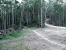
The flouro trails on this pic are not yet open.
"Possums" is not shown on this pic.
(sorry mod I struggle posting pics)
http://nobmob.com/taxonomy/term/393
OK I had no idea that track even existed. I'll keep riding as I have been
here's what it says on the NPWS page for Garigal NP alerts:
At Bantry Bay within Garigal National Park two mountain bike tracks are currently under construction:
1. Serrata track in consists of 1.5 km single width track with the remaining 1.35 km as the Currie Road and Cook Street trails; and
2. Gahnia track being 3.6 km consisting of 2.25 km single width track with the remainder as the Bluff and Engravings trails.
I don't know if these names (Serrata and Gahnia) will feature in the signage for the two trails. As I understand it NPWS are waiting for the new signs and this is currently delaying the opening of the western trail i.e. the trail on the western side of Bantry Bay Vs the Eastern loop (eastern side of Bantry Bay) which I believe is awaiting the installation of a major bridge section designed to route traffic away from a sensitive area..
Its riders on the unfinished single track loop that starts at Bluff and ends at Engravings track that is the major source of anger from NPWS.
Do not ride.
whats the deal with the other track which says its to be rejuvenated? comes off near the Manly Dam wakehurst entrance and comes out near where they've built the new roads ....I think?
@kitttheknightrider
so the trail i posted above is closed? as its a fluro trail listed on your map
Seems there has even been cycling stores riding that trail
AFAIK none of the new trails are yet open, regardless of whether or not one may be finished. The green parallel to Wakehurst Parkway is an existing "fire trail" so I don't believe there are any issues using that to get up to Possums. I can't comment on the green trails on the western side of the bay as I have never been over there.
Engravings, Bluff, Currie Rd and Cook St are all existing fire trails and so no probs riding these. The new trails are the pink ones on the maps. West (a.k.a. Serrata) and East (a.k.a. Ghana) are new purpose built single trail exclusively for mtb riders and represent a major investment for NPWS against a strident opposition from several very vocal groups. It's really important we work with NPWS through this project as any issues will no doubt be used by these naysayers to oppose similar project in other parks. Common guys it's only a matter of a week or two until the western trail should have a soft opening. NPWS probably won't do a major announcement at first for the western loop and are more likely to give it a chance to bed in just in case any adjustments are necessary. I'm guessing an official announcement is more likely once both loops are ready to go.
I emailed NPWS last night as there seems to be a lot of confusion but no reply yet.
If spindog is correct and the pink trails are the new ones who is going to call Cyclery Northside and ask them to keep off the new trails? If its not them then they need to do something about someone using their name and riding trails like this as its not a good look is it
Here is the list of users if anyone is interested in shaming them. There are lots of them
http://www.strava.com/segments/npws-bantry-bay-w...
Spoke to the senior manager on duty at Cyclery Northside to bring this to his attention, particularly riding the eastern single track section.
He's going to have a word to his staff and I've asked him to get back to me. I'm not holding my breath on that, but we'll see.
Is there really a need to put up a list of 'strava only' people that have ridden it? Come on, grow up! I would say that there is a good chance, close to, if not 100%, of riders have ridden an unauthorised trail at some point in time. I have and do, not these but plenty of others. It's called exploring!
You're missing the point.
This is not about riding unauthorized trails, of which i have ridden plenty, but ones that are clearly and deliberately signed as closed, and doing environmental damage as a result.
This is jeopardising the opportunity to have further authorised trails built in NSW NPs.
Is your memory so short that you don't remember us being locked out 5 years ago?
Do you want to go back there?
I don't.
@jbsp1, grow up you say, i think we have, its the immature twats that are riding this clearly sign posted trail that need to grow up.
You only have to look at OMV and the lack of respect people had that trail before it opened. It had gates and signs but people basically ripped them down and entered the trail to ride it early. Some mountain bikers just have no idea
As hawkeye has mentioned already, this is a matter of life or death for not only this trail, but others in national parks Australia wide. If people cannot, and refuse, to obey a closed sign on a trailhead what do you think it says about the mountain biking community in general? We all get tarred with the same brush and those that think one ride wont hurt will cruel it for everyone.
I also emailed Northside Cyclery and told them it looks pretty damn bad that their own staff cant obey a closed sign and they need to do something about it. My guess is their name will be removed from the list pretty quickly and they wont log any further rides on this trail
Fair enough! To blatantly ignore a large sign clearly marking the head of the trail saying it is closed is not good? It obviously stats that for a reason, which would usually be that the trail is not yet ready for traffic.
On the eastern side is there the same type of sign at the trail head? We are not talking about secret squirrel trail are we?
And no, I don't want to go back there! But I still don't think that naming and shaming only the people from strava is the right thing to do
Remember the mid '80s and the furore over the Australia card.
Oooooh, big brudder's gunna be watching you..... Oh how the proponents must be laughing now. There's no escape in a digital world.
Have at the mongrels posting their illegal rides on Strava. I'll keep flying under the radar with my rotary dial phone, IE5 and paper maps.
I don't think any of this is a threat to nationwide NP access for mtb's. It's only NSW NPWS that seems to have a stick up its arse about the issue of mtb's in NP's. Everywhere else seems to be getting on with it. When there's plenty of trails there's less incentive to go ride stuff before it's finished, but we are a along way from the land of plenty in NSW....
I take it that's not you logging rides under my name on Strava? It's got to be someone fit, they're on the leader board.
My two cents...
On Eastern side...Trail under construction, info about environmentally sensitive areas in public domain.... Closed sign or not probably should stay off. Then again land adjacent was carved off the national park, bulldozed and houses built on it.... and the sediment / run off will damage these areas more than any MTB.
On the western side... A trail that is 100% complete for at least 6 weeks but has a closed sign.... For what.... Waiting for an open sign to be installed???
At the end of the day some people will follow rules and the direction of authorities no matter what, others won't follow rules no matter what the damage and others will look at the rules, a bunch of other factors and make a judgement call.... And of course there is everything in between.
This is all normal and expected behaviour and should have been expected, considered and pragmatically mitigated during project planning; I.e by installing the bridges over sensitive areas first instead of last....
Not a threat nationally, just in NSW, the Red Tape State.
Daniel has a point around the project planning, major prioritisation fail there, and an entirely predictable turn of events.
Nevertheless, there has been feedback from NPWS that they are not happy about what's been going on on the eastern trail and we need to get word out.
Simon, perhaps some feedback should be going back to them about what is essentially a planning failure.
Looks like Cyclery Northside has made their ride "private".
I've left messages for a couple of others that I found asking them please not to ride the eastern section.
It will be easier to monitor if someone sets up a segment for the eastern section, but not sure how to do that with someone else's ride.
Putting up Strava segments - 'naming and shaming.
I agree with danielschipper particularly in regards to poor project planning. It needs to be stated that for better or worse, the mtn bike 'culture' on the Nth Beaches, has been to ride illegal trails so not surprising this is happening. It is also quite 'Australian' to buck authority. Not saying it is right, but the way it is.
There are some people on here with very short memories (or haven't been riding so long) as it was this site that was responsible for getting us all kicked out of Oxford falls several years ago - as well as Bantry bay. The latter has now been carved up for housing in the most hypocritical of moves after telling us for years how much 'damage' we where doing.
I'm with goatman
And let's remember that it is NPWS brief to increase visitation
Using MTB to instil a love of the bush in kids, families, and everyone else is obvious
To declare that a project is in jeopardy because a few ignorant people can't help themselves is ludicrous and defies logic
It's like the government refusing to build more roads until everyone sticks to the speed limit, learn how to control their cars properly, pay more attention, and never hog the right lane
Nothing wrong with getting the word out to stay off the trail until it's finished
And it's fair enough that the NPWS is pissed off
But let's not play the name and shame game BS
Unless it's against the appalling lack of facilities to ride in Sydney in particular, and NSW generally
Speed Kills remember... except that it doesn't!!!
The authorities and departments that are meant to be in place to serve us and provide services to us have not earned the right to be trusted, in fact just the opposite. Therefore many people will take direction / rules as guidance and test it against logic; particularly when those authorities are trying to protect us from ourselves or from their public liability insurers.
Bantry Bay is a classic example. The western trail appears to have been finished a good 6 weeks ago but is still closed due to lack of signage... so a SIGN HAS BEEN PUT UP stating that the trail is closed. That's a logic gap and it deserves to be treated accordingly. Of course there could be a good reason that the trail is finished and still closed; but that needs to be clearly and simply explained.
So here's an opportunity for NPWS. Instead of being pissed off why not recognise that no project goes 100% to plan, record some lessons learned for next time and put in place some immediate mitigation; i.e. provide a simple statement on this site and in the local media explaining why the two trails are closed, provide and update the ETA for opening, and link through to more information. Also put some clear signs up at the trail head; not just stating that the trails are closed but stating WHY the trails are closed and what the impact of riding them will be... and not some childish measure of... or we'll delay the opening and not give you an more trails... but the REAL reasons.
If people still make a decision to ride the trails.... then learn from that also. Try to understand why and treat the cause not the symptom.
Last but not least. Thank you NPWS for building these trails. They are going to be a fantastic asset for the local community and, once the dust has settled, will be a good example of how access to National Parks does not need to result in compromise to the sustainability of National Parks.
/end rant
^^^^LIKE
All of this comment about logic gaps and poor planning is fair enough (to which could be added using Chinese suppliers instead of local - what is that doing to the projects carbon footprint?).
Nonetheless damage is being done to endangered ecological communities along the eastern trail corridor, which needs to stop.
Or are we the uncaring environmental thugs that Rosemary and the NPA believe us to be?
TrailCare whom sits on National Parks committee and provides representation for riders and has key organisation representatives on our committee has been asked to help stop people riding on these tracks. This in addition to closed track signage is one of their main forms of distributing information, TrailCare through me has been since 2008. TrailCares main role is liaison and mediation between government and riders and to provide a considered lobbying voice.
This thread was a simple request to the riding community for some self management and to contact and get riders any of us know out of unfinished tracks where they are not welcome.
Some of the comments on this thread, which is in the public domain basically forever, are as damaging to rider reputation than those riding on the tracks. This thread and website is trolled by the counter lobby against riders, some of whom are paid environmental lobbyists who do this for a living.
We as riders managed to get NPWS to change their policy towards us by being reasonable, easy to work with and respectful.
Please think about how your publicly posted comments may be perceived by others, especially parks whom while under resourced have been busting their arse to deliver this for riders. The key guys in NPWS managing this track are also riders.
There has been no planning failure or any failure by NPWS. In most construction projects things are identitied once you start digging. This is the case and as a result more raised areas are needed.
This track is also officially a study of trail impact in Sydney's environment and a study of whether they wish to pursue any other tracks in Sydney. Environmentally this study includes detailed baseline measurement of flora and fauna following track completion. This way any impact can be monitored over several years. Riding the track now risks stuffing up baseline data.
Signage is also required for legal reasons to manage risk. NPWS appetite for risk is also better being a State organisation compared to local councils. As a land manager they reserve the right to protect themselves and waiting for the signage to do this is reasonable.
Manly Dams lack of signage and risk exposure this poses to Warringah Council is unusual in the context we now live and ride in.
For the record Australian national parks are not national. They are state based but called national parks and managed by the state. Issues in Sydney with the pilot study at Bantry Bay will likely only stuff things up for Sydney riders.
Hopefully people will take notice of your information in a positive way