
You are here
glenrocktrailalliance.com

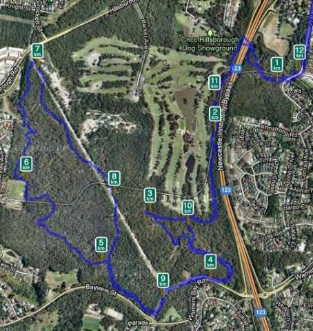
Warners Bay Ride.
It has been a while since I have logged on here and I am glad there is now a Warners bay Ride section.
This is my local ride. Just a few minutes from my front door I enter the area from The bottom of EK Ave/Waratah Ave. Take the tunnel under Charlestown bypass and you end up beside Charlestown Gold Course.
The area has a mix of fire trail and single track. It can be rough and rutted in areas with some traffic from 4x4's and motor bikes. Ground varies with sandy gravel, rocky trails and is quite muddy after some rain.
Awaba State Forest update for 08 Apr
A few patches of mud and the odd puddle but overall pretty good.
Do you have more information?
If you've ridden here lately please add a more recent report. This will be useful even if the condition is the same as updates expire after 30 days.
Please do not post comments with such information - post a new update with the link above.
Please do not update this post with such information - post a new update with the link above.

Warners Bay update for 08 Apr
Motorbikes have found some of the single track and so with the recent rain a lot of the tight turns are now just deep ruts full of water and mud. Most of the tracks are OK but soft in places.
Do you have more information?
If you've ridden here lately please add a more recent report. This will be useful even if the condition is the same as updates expire after 30 days.
Please do not post comments with such information - post a new update with the link above.
Please do not update this post with such information - post a new update with the link above.
Glenrock State Conservation Area update for 05 Apr
Just barely amber - Kenny's etc will be quite wet , staying around the firetrails and around gun club rd is all pretty acceptable with the odd puddle but not widespread mud.
Need a good weekend of sun
Do you have more information?
If you've ridden here lately please add a more recent report. This will be useful even if the condition is the same as updates expire after 30 days.
Please do not post comments with such information - post a new update with the link above.
Please do not update this post with such information - post a new update with the link above.

Altitude Sickness.
Being born and lived all my life about 5meters above sea level, has anyone or know anyone that has experienced riding in altitude. I’ve done Whistler but you get lifted up to approx 2200meters and the villages are all around 650meters and there’s no problem. I’ve got an opportunity to go to Mont Blanc via Hungary. Do a search for Mont Blanc Mountain Bike tours and get ready to catch some drool.... Land at Geneva ride through Switzerland, France and Italy. I just cant find anyone that has experienced riding at real altitude first hand.

Glenrock State Conservation Area update for 04 Apr
Really wet now, has put a halt to trailwork.
We can only hope it clears. Radar is looking better ATM
Do you have more information?
If you've ridden here lately please add a more recent report. This will be useful even if the condition is the same as updates expire after 30 days.
Please do not post comments with such information - post a new update with the link above.
Please do not update this post with such information - post a new update with the link above.
Too_Many

Too many bits, pices & bikes.
Glenrock State Conservation Area update for 03 Apr
The NPWS trailwork crew got washed out from Shaft about lunch time so it's not looking good at all.
I'd say it's amber or worse.
Do you have more information?
If you've ridden here lately please add a more recent report. This will be useful even if the condition is the same as updates expire after 30 days.
Please do not post comments with such information - post a new update with the link above.
Please do not update this post with such information - post a new update with the link above.
Western Firetrail Alternate
Alternate climb option to the nearby firetrail. All end up in the same location and no real benefit one of the other.
Dangerfield Dip
Steady drop off the fire trail access and climb back out. Access via Dangerfield drive as well.