You are here
nobmob.com


Sun 25th EAST Terry Hills
Meet at Terry Hills shops 1:00pm
This ride consists of a new trail as well as Duck Ponds & Central Trails to form a loop
of sorts.
Time to stretch the legs after the rain!
C U There
Jeff

Yellowmundee Saturday 24th June
Given the amount of rain we have had over the last couple of weeks and the amount forecast to fall between now and the weekend, particularly along the coast, I was thinking of heading inland a little to ride at Yellowmunde this Saturday. It is located at the foot of the mountains, roughly half way between Penrith and Richmond but on the other side of the river. For directions go to http://www.wsmtb.com/xc.shtml Should be alot drier than anything we have on offer at the moment.
Please note this is a tentative ride only at the moment. WSMTB are holding an 8hr event there the following weekend and I have sent them an e-mail to check that the trails are open and not closed for maintenance in prep for the following weekend.

Day trip to Ourimbah?
Here's a coincidence... (or is it?):
Our poll about days away now has Ourimbah as a leader, and as luck would have it, everyone's favourite mapping tool now has hi-res pictures of the area. As such, I slapped together a couple of rough maps:
Ourimbah Overview - shows the whole area.
Ourimbah Downhill - shows that small area in the north with all the good stuff.
This was mostly done from investigation on topo maps, and it looks although a couple of healthy circuits can be made to compliment the downhill fun we all know is in here someplace.
Ourimbah in Google Earth
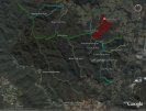
WARNING: There are many smaller trails that lead to dead ends off many of these trails, particularly Prestons Ridge, Red Hill & Middle Ridge. I haven't ridden any of them (as yet) either.
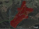
Shown here is are those trails from the topo map that looked like they could be joined up to form half decent loops without too much time on the road.
Red section is shown in more detail here.
Ourimbah in Google Earth - Downhill
WARNING: Some of these are from our GPS recordings, the others are from a topo map - names are from a few loose maps I found lying around (only Roller Coaster is signposted there).
Overview of the rest of Ourimbah here.

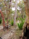
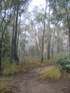
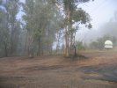
17/18 June
... and what a weekend it was! After the deluge of previous weeks great to be out in the winter sun.


Fantastic stuff with some XC exploration in Wingello State Forest (right) and another round of technical training at Red Hill (above), about which Greg wrote a few words here.
Check the respective galleries (Wingello & Red Hill) for all the pics.
More of the same next time please 
