You are here
nobmob.com

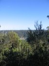
Nepean River
At a Glance
Fire Trail running parallel to the Nepean River from Emu Heights to Yellomundee Regional Park.
Not for Beginners

Nepean River
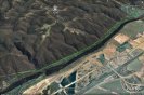
Google Map of Fire trail Parrallel to Nepean River. Running from Emu Heights to Yellomundee Regional Park

Draft Warringah Bike Plan, Public Submissions Needed!
Draft Warringah Bike Plan will be on Public Exhibition: Saturday February 27 to Wednesday March 31, 2010
http://www.warringah.nsw.gov.au/comment/comment....
View the Draft Warringah Bike Plan and Bike Maps:
http://www.warringah.nsw.gov.au/comment/document...
The Draft Warringah Bike Plan and Bike Maps can also be viewed at the following locations during the public exhibition period:
Council's Civic Centre, 725 Pittwater Road, Dee Why
Warringah libraries: Dee Why, Belrose, Warringah Mall, Forestville and Terrey Hills
Have your say


Ourimbah State Forest update for 13 Mar
Only a few patches of standing water and only a couple places of mud that you could probably avoid if you could be bothered 
Dam track - nice 'n' grippy. Get out there 
Do you have more information?
If you've ridden here lately please add a more recent report. This will be useful even if the condition is the same as updates expire after 30 days.
Please do not post comments with such information - post a new update with the link above.
Please do not update this post with such information - post a new update with the link above.

Ryland update for 13 Mar
If you are using Ryland to link to Sandy then take great care on the steep sections. There is a tree down blocking the full width of the trail, on the steepest section, just past the sign warning of steep sections ahead. Always laugh when I see that sign given what you have come down to get to it. If you were coming down with any speed there is no way you'd stop in time.
Otherwise track is good. Sandy has been graded and should be left alone for a while.
Do you have more information?
If you've ridden here lately please add a more recent report. This will be useful even if the condition is the same as updates expire after 30 days.
Please do not post comments with such information - post a new update with the link above.
Please do not update this post with such information - post a new update with the link above.
Terrey Hills update for 13 Mar
Just a note on Sandy Track, it has recently been graded by what appears to be a 7yr old kid trying to make the biggest sand pit in Sydney, He succeeded. Very very loose, will be an absolute bog in the heavy rain. There are now steep sections leading up to waterbars that make the concrete entrance / exit at the "west" end look like a speed bump. The flatter sections towards the top that are normally wet and muddy from the run off from the adjacent horse paddock are now one long bog.
If you're linking to Ryland be careful, there is a tree down there on the steepest part of the trail that blocks the full width of the trail. More an issue if you were coming down Ryland towards Sandy.
Do you have more information?
If you've ridden here lately please add a more recent report. This will be useful even if the condition is the same as updates expire after 30 days.
Please do not post comments with such information - post a new update with the link above.
Please do not update this post with such information - post a new update with the link above.

Red Hill update for 13 Mar
Slightly drier than 2 weeks ago, but still some puddles & boggy sections that should be walked.
I don't think I can call it Green, just yet.
No snakes, but!
Do you have more information?
If you've ridden here lately please add a more recent report. This will be useful even if the condition is the same as updates expire after 30 days.
Please do not post comments with such information - post a new update with the link above.
Please do not update this post with such information - post a new update with the link above.

SMH: Sydney: The city that hates bikes....

Sydney Morning Herald Article:
http://www.smh.com.au/nsw/sydney-the-city-that-h...
Research paper:
http://policy.rutgers.edu/faculty/pucher/PucherG...