
You are here
nobmob.com

Top of Towers (almost)
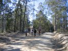
Last incline to the top of the downhill track, which starts just to the right of the tower up there.


Weekend 19-20th those not going to Ourimbah..Local ride anyone?
Ok, anyone feel like a ride local this weekend?
Speak up if you have any thoughts on Saturday morning or Sunday morning and we can arrange from there?
Red Hill last weekend was very wet in places with some deep deep puddles. Overall it was a great ride on some new tracks I havent experienced before.
Craig
Manly Dam Bike Track Open
I'm relaying this message from the Rangers, if you have any questions please email them direct at the address below.
The bike trail at Manly Dam has re-opened.
Many thanks to all for keeping off the trail during this very wet period.
Nicole
P.S. Don't forget the bike trail maintenance day at Manly Dam has been organised for Sunday 17th September 2006.
Manly Dam Closed
Updated - Aug 14
We've had a mail from the rangers this morning, "The dam is still closed for riding as there are some trouble spots that still have not dried out. We will be having discussions this week about the re-opening and will inform the riders..."
Sorry to be the bearer of bad news, but if this glorious weather keeps up perhaps it will be back on at the weekend.
See the comments on this post for details of how you can help out with the maintenance day at Manly Dam on September 17th.
Sat 19 - Ourimbah
Coming Saturday, the long awaited trip to Ourimbah is on as discussed: Day trip to Ourimbah?. See that thread for discussion, but seems time to play in the downhill area is the go, plus perhaps a further venture on some of the fire trail is a possibility (TBD on the day).
Meet 9am, North end of Red Hill Road as per the map here. You can clearly see the freeway turnoff from this view (which I believe is sign posted 'Wyong' - thx arpit). If you enter, "Red Hill Forest Rd, Ourimbah, New South Wales" into Whereis you should get decent directions.
Stoned Leg
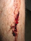
Think plain old fire trail is safe? Think again... this is what happens when a large (erm... size of your fist) rock decides to jump up off said trail and bite on your shin!
Happened on a downhill section of the Wildflower Management fire trail, doing 30-35K/h I guess.
Rock hit about dead centre of the shot (where the nice deep red colour is), rest of the stuff gooed out over the rest of the ride (another 2 hours or so).
It's a nice deep hole as you can see from what happened two weeks later, and eventually (after a month or so) left a sma

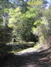
By Meuller Junction

On the management track by the junction with the Meuller Track. Don't go down there as it's closed to bikes (and besides, you'd have to carry the bike up the steps at the other end).