You are here
Northern Beaches Trail Advocacy
Royal National Park Trail Maintenance Day - Saturday 19th September
Just an update on the ongoing trail maintenance being undertaken in the Royal National Park at the moment.
A second day is now confirmed for 9am Saturday 19th September and if anyone wishes to participate, here is the link to the original post that has all the details. http://nobmob.com/node/10019
I couldn't make it to the first one, due to work commitments, but I have seen the improvements on recent rides and there has been some good work carried out to improve drainage in a few areas.
It looks like drainage is going to be the main focus on the 19th.
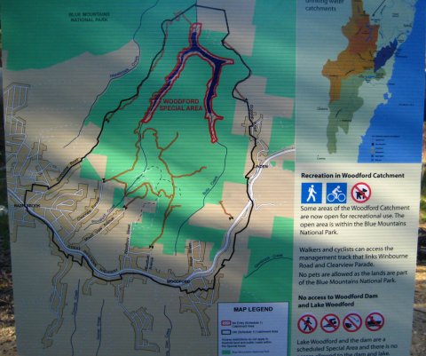
New mountain bike tracks in the Blue Mountains
Thanks to some tireless campaigning by a few fellow riders it seems that SCA have taken a small step in the right direction and granted access to some land around Woodford Dam.
I'm not sure about any specific trails in this area, but as noted, it is a step in the right direction. In the words of Oliver Twist, "Please sir, may we have some more?". There would be some real epic rides available in the Blue Mountains if other SCA lands are opened up.
Anyhow, press release here and quoted below:
North Shore Times: Conservation before recreation in parks
Pretty nasty headline for a pretty poor write up of last week's events:
North End of Bantry Bay to be developed
I've been told today that the Land & Environment Court has recently approved development on 9-11 Bantry Bay Road.
We first talked about this here: http://nobmob.com/node/1293#comment-1767
At first thought this isn't a huge deal for riders as:
a) You shouldn't be riding there anyhow as it's part of the illegal Bantry Bay loop.
b) Any development will surely have to have some sort of border which should be on the developed land (ie. not National Park) and may well lead to a short cut round to the Scout Hut without having to take the road.
Red Hill DAs
Something to come out of the meetings we've had over the last few weeks is the fact that the conservation, bushwalking and other lobbies have a lot more in common than you'd think.
Highlighting this is the fact that a number of DA plans that would affect Red Hill riding are awaiting approval. Below is a list of those that one of the other groups created, it sounds quiet serious. 
There are a number of disastrous developments in the pipeline at Red Hill and the surrounding bushland and all of them would destroy walking and biking areas.
Further information can be found on the Warringah Council web site under DA's on-line. Be warned that a set of DA reports can be 1000 pages long so they take a while to read. They are in smaller pdf files though, so can be downloaded bit by bit.
Nearly all the land from Red Hill to Oxford Falls and Narrabeen Lagoon is under threat of development and unless we fight for it, it is unlikely to be available for walkers or bikers to enjoy in 10 years time or perhaps much less. The same goes for a lot of the bushland at Ingleside, Terry Hills, Duffy's Forest, etc, etc. This is why the National Parks are so important as they will be the only bushland remaining soon.
Mike Baird is helping us!
http://www.mikebaird.com.au/interactive/manly_ne...
Wednesday, 12 August 2009
Manly MP Mike Baird is today meeting with the Environment Minister Carmel Tebbutt to find a solution that would give mountain bikers access to sustainable tracks but ensure the environment is protected.“I believe a win-win situation is possible. Our national parks must be protected but they should also be enjoyed,” Mr Baird said.
Show your support for LCNP trails!
Next week (Aug 18) there will be a NPWS public meeting regarding the LCNP plan of management. As previously discussed, and as per the meeting here:
If you care about riding in LCNP or other Sydney parks it's important to turn up and show your support. Please make time and come along if you can.
I guess they are expecting a large turnout as you must register your intent to show up at this meeting, by one of these methods:
Email [email protected] (preferred)
Tel: 02 8448 0400
All good? See you there!
Liverpool Council Bike plan call for submissions
Guys, just a headsup.
Liverpool council has produced a draft cycling plan and it is now open to public comments until August 19th.
http://www.liverpool.nsw.gov.au/LCC/INTERNET/me....
The plan mentions every form of cycling except MTB! Amazing when you consider how many young people live in that area, and the proximity to council bushland and reserves.
Now is the chance to be heard. Might also be a good idea to submit the excellent Nobmob Oxford Falls document as a reference item, since it covers many of the general social aspects of MTB.
Proposed trail network/extension for Narrabeen Lagoon
I ride this with my kids. As I'm only new to this site and the sport, don't know if there's any oppurtunity for some input from the Mountain Biking fraternity, anyway, check it out;
Toddy
Updated Google Earth NPWS File
NSW National Parks have just this month released their updated boundry data that shows all areas in NSW that are managed by National Parks.
Download KML (shamelessly stolen from Geocaching NSW )

