You are here
Sydney (South)
Appin
At a Glance


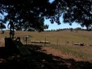
Appin is currently closed!
See: Appin needs your support!
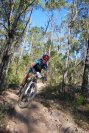
Brilliant and technical XC course built by the kind folk at WMBC - one of the finest around Sydney. Looks to be plenty of firetrail in the area too, but with sniggle this good, why would you waste your time there?
Camden River
At a Glance
AKA River Run or 9 Bridges.
Garden Trail (Australian Botanic Garden)
At a Glance

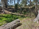
Another creek crossing
Overlooking a creek crossing from a bluff, this steep downhill picks up speed quickly, then crosses a rock covered creek into a rock garden climb.
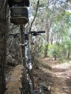
Downhill sniggle - part 2
A fast blast through the trees over various humps and bumps - it links together to form a rollercoaster of trail - some of the best sniggle at Mt Annan.
The Playground - continued

Some more techy sections... a couple of rocky roll-offs leading into a hairpin bend.
The Garden Trail is an 11km cross-country (XC) circuit which is 95% single trail and comprised of three loops which become progressively more difficult. The loops can be ridden independently or combined for the full 11km.
Heathcote National Park
At a Glance
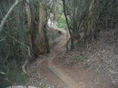
It is no longer possible to ride along the train line from Waterfall to Heathcote. To complete a loop of the Royal National Park crossing over and riding North inside Heathcote National Park seems a far better idea. The electricity management trail that runs south from Mirang firetrail is very rough in places and hasn't been graded in years.
To do a loop of the Heathcote NP, ride Mirang firetrail downhill for about 2.5km before joining the pipeline track. Following this south will eventually lead to the Woronora Dam Road. Turn right to go to the dam or turn left to head back to Waterfall.
A singletrack starts to the west of the industrial area at Heathcote.
It winds up and down the ridges before emerging halfway along the Mirange Firetrail.
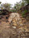
From here head back towards the highway along Mirang and another singletrack starts on the right hand side. This is a very nice singletrack - a bit technical in places but flowy in others. There is quite a steep climb at the end just before it emerges on the Abaroo Creek firetrail. There is quite a steep climb up this firetrail for about 500m. About 3/4 of the way up there is a small trail on the RH side which leads to some aboriginal rock carvings.
The Abaroo firetrail then joins the Sebasterpol firetrail that leads back to the highway or the electricity management trail.
Menai (Lucas Heights)
At a Glance


Many trails exist in this area, but these were closed by land managers for a period. As of mid-2014 there is now a dedicated network of around 13km of single track to explore.
Mowbray Park Farm
At a Glance

Through Ewe Fence bridge

There are 11 fence bridges in total

Start and Finish
Use this fence bridge to access the track and exit.
A bridge in the Wetlands wander
Events only. A fast and flowy XC track that has been tested using 26" and 29" bikes, male and female riders, 13-60 year olds, a cyclocross and one crazy guy on a fatbike.
The venue is also a working farm so there should be plenty to do for the rest of the family.
Royal National Park
At a Glance


Royal Bush Fire Re-growth

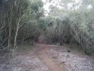
There's some great single trail around the Royal National Park. Here's a section that's a bit eerie. Apparently all but destroyed by bush fires a few years back there's a lot of green re-growth stuff about.
There are many, many trails in the Royal National Park, string together a few to make your ride as long short as you like.