You are here
Northern Beaches
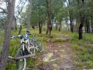
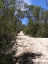
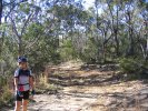
Bairne Track
At a Glance


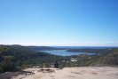
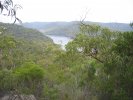
Pittwater from Portuguese Track
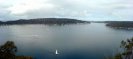
There's a sheer drop about 1m in front of the photographer - very cool 
Round to the right one can see wharfs along Towlers Bay (which you can also ride down to).
An easy firetrail that would make an ideal introduction to MTB for beginners. A quiet ride and great views over Pittwater are your reward.
Bantry Bay
At a Glance


Some out & back trails that make a nice addition to a lap of Manly Dam. The Cook Street Track in particular is a real lung buster and great climbing training.
Cascades
At a Glance


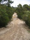
Cascades is a good test of your cardio fitness - lots of hills and not much technical stuff means easy riding if you have average to good fitness.
Centre Track
At a Glance
Centre Panorama
Looking out here and not seeing a building, road or person for as far as this it's hard to beleive you're just 30 mins drive from central Sydney.
Another short-ish track in Ku-ring-gai to link up with others.
Chiltern Track
At a Glance
Not really a ride - but a testy little hill to join up or tag onto others in the area.
Duck Hole/Terrey Hills Trail
At a Glance
Duck Hole Entrance

Number 301/303 McCarrs Creek Road. Follow this driveway to the West end of Terrey Hills Trail.
It's not obvious where or why, but this changes it's name to 'Duck Hole Track' part way along.
A nice easy track to join with others in the area for making longer routes.
Elvina Track
At a Glance
Short but very steep.
Manly Dam
At a Glance
Downhill Fun
Take it easy - the decent to the creek is fast, rocky, slippery in the wet and full of gotchas.
Update: As of December 2006 this trail had some access work and has changed to more of a Downhill Freeway 
Heartbreak Hill
There's often not much grip here. Lucky this little climb is short and sweet - power on up there!
Sadly this was graded sometime around Dec 2006, so there's no real challenge in it left. After that it looked like this.
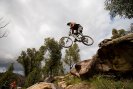
19th Hole
Biggest drop on the circuit and 6 foot plus. If you didn't turn right at the end of the boards then you're probably lying broken here.
One of Sydney's best rides - From Less experienced to Intermediate and even Advanced, all enjoy this ride.
Oxford Falls (Morgan Road)
At a Glance
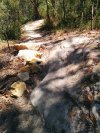
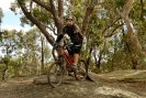
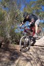
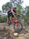
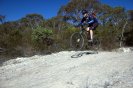
Sandy Fun
Between the two rather serious climbs here there's a section of trail that's quiet sandy.
Perfect for playing around as T-Bone demonstrates (well - if you check the original full size, you'll see he's on one wheel here).

Also know as Morgan Rd for it's meeting point this area has heaps of trails to join up and make the ride anything you like. Most of these have at least one or two technical sections, many are 80%+ technical!
Red Hill
At a Glance

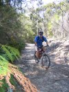
Red Hill Rollover Jeff
Jeff tackling a steep roll over on a new section of single trail we located yesterday (22/4/06).
Steps or Drop
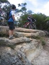
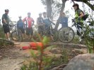
The guys discussing whether to come down the steps (toward the camera - which most did) or just jump off the drop to the right (which Greg did!).
Red Hill is super-tough and super-technical. Climbing Red Hill has reduced strong MTBers to tears.
Ryland & Muppets
At a Glance
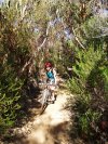
100m Walk
Looking back to the creek crossing. This trail is marked as a walking track, but the 100m or so around this point is about all there is that isn't really fire trail.

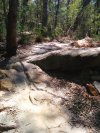
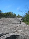
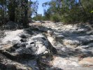
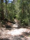
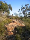
Water Bar Madness
This trail is marked as a walking trail on the topo map, but clearly is not. It's way steep fire trail with lots of water bar madness to be had on the way down. Take care!
Pallet Bridge

Don't suppose this pallet bridge was really needed (there's a path over this gap to the right) but someone found it fun to put down here anyhow.
Although these tracks can make a nice out and back sort of ride in their own right, their main purpose in life (well, at least for us) is to join with Terrey Hills and Wildflower Garden, from which points you can make a huge circuit if crazy enough. Also, Muppets is a nice little single trail loop of a little over 2km.
Salvation Tracks
At a Glance
Wallaroo Jeff

Jeff on one of the steeper drops on the Wallaroo Arm. It doesn't look much as usual, and to be honest if you stay in the centre here you can't go far wrong.
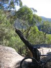
Wallaroo View
View from the end of the Wallaroo Track. It's a bit overgrown here so don't come this way just for what you see here.
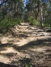
Wallaroo Rubble

On the Wallaroo arm, plenty of loose rocky rubble (up to cricket ball size) here so grip isn't the best.
Nice out and back firetrail where the only climbs to speak of are short, steep, and some suprisingly technical.
Terrey Hills / Duffys Forest
At a Glance

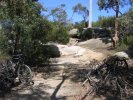
Anembo Junction
Curling round to the left is shorest route back to the fire station. To the right where the bikes are is that short cut across the circuit and out of shot (to the camera's left) is the supposed route to Bibbenluke.
Fire trail. Not technical, but one of the best views at the end of the Long Trail. Some more challenging climbs to be had on the options south of Booralie Road.
The Grove Bike Park
At a Glance


This is an official Manly Council facility containing dirt jump and a pump track.
Towlers Bay
At a Glance
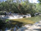
Towlers Track View

Looking down to Morning Bay and the derilict wharf by Towlers Bay Cottage where you'll be in a few short minutes.
Halls Wharf Exit

As you leave Halls Wharf the climbing begins. Suck it up, because there's plenty of grinding to come.
Short-ish (9K?) out and back style ride down some steep firetrail, along the water's edge and back up.
Waratah Track
At a Glance
Waratah View

Well, through the trees there is anyhow... I think that's Cottage Point down there (where the boats are moored).
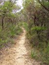
Another out and back to the West of West Head Road. Not quiet as rocky or steep as Salvation Tracks but still some challenging sections and a nice view at the end.
Warrimoo Track
At a Glance
Warrimoo End
End of the Warrimoo Track. OK - well the end for cyclists anyhow, the walking track continues down though.

Warrimoo Start

There's a small carpark here, at the end of Warrimoo Avenue, St Ives (the junction with Timbarra Road).
Tiny little out and back with quiet a steep drop at the end.
Wildflower Garden
At a Glance
Overgrown Junction

Off to the left is the overgrown dead end track. Not even a decent view at the end

Killer climbs from Ku-ring-gai creek tempered by some nice firetrail and even a small section of single track. Some sealed roads to take joining it up though.